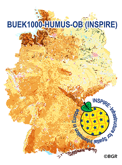
The WMS of the map „Organic Matter Content of Top-Soils in Germany 1:1,000,000 (INSPIRE)“ highlights the results of a Germany-wide compilation of typical soil organic matter contents in top-soils differentiated according to groups of soil parent material, four climatic areas and the main land use. The evaluation is based on more than 9000 soil data profiles with information about Soil Organic Matter (SOM) from a period of about 20 years. The report 'The Organic Matter Content of Top-Soils in Germany', BGR Archive, No. 0127036 (in German) documents the methodology. To transform the organic matter content (of the original dataset HUMUS1000OB) into INSPIRE-relevant organic carbon content (CORG), we applied the van Bemmelen factor (1.724). According to the “Data Specification on Soil“ (D2.8.III.3_v3.0) and the “Guidelines for the use of Observations & Measurements and Sensor Web Enablement-related standards in INSPIRE“ (D2.9_v3.0) the map “Organic Matter Content of Top-Soils in Germany 1:1,000,000“ provides INSPIRE-compliant data. The data has been transformed into the following INSPIRE-Feature Types (Spatial Object Types): “SoilDerivedObject“, “OM_Observation“ and “OM_Process“. Der WMS zur „Karte der Gehalte an organischer Substanz in Oberböden Deutschlands 1:1.000.000 (INSPIRE)“ visualisiert die Ergebnisse der deutschlandweiten Zusammenstellung von typischen Gehalten an organischer Substanz der Oberböden differenziert nach 15 Bodenausgangsgesteinsgruppen, der Landnutzung und vier Klimaregionen. Die Auswertung basiert auf mehr als 9000 Bodenprofilen, zu denen qualitätsgesicherte Daten zur organischen Substanz aus einem zwanzigjährigen Zeitraum vorlagen. Das methodische Vorgehen ist in dem Bericht 'Gehalte an organischer Substanz in Oberböden Deutschlands', BGR-Archiv, Nr. 0127036 dokumentiert. Für die Umsetzung nach INSPIRE wurde der Gehalt an organischer Substanz (des Ursprungsdatensatzes HUMUS1000OB) mit Hilfe des Van-Bemmelen-Faktors (1,724) in Gehalt an organischem Kohlenstoff (CORG) umgerechnet. Entsprechend der „Data Specification on Soil“ (D2.8.III.3_v3.0) sowie der „Guidelines for the use of Observations & Measurements and Sensor Web Enablement-related standards in INSPIRE“ (D2.9_v3.0) liegen die Inhalte der Karte „Gehalte an organischer Substanz in Oberböden Deutschlands 1:1.000.000“ INSPIRE-konform vor. Die Umsetzung erfolgte in die INSPIRE-Feature Types (Spatial Object Types) „SoilDerivedObject“, „OM_Observation“ and „OM_Process“.
Raumbezug
Lage der Geodaten (in WGS84)
| SW Länge/Breite | NO Länge/Breite | |
|---|---|---|
| 5.56°/47.14° | 15.57°/55.06° |
| Koordinatensystem |
|---|
Verweise und Downloads
Querverweise (1)
Nutzung
| Nutzungsbedingungen |
Terms of Use: General terms and conditions, see https://www.bgr.bund.de/AGB_en. For further use provided information has to be cited as follows: BUEK1000-HUMUS-OB, (c) BGR Hannover, 2022 Dieser Datensatz kann gemäß der "Nutzungsbestimmungen für die Bereitstellung von Geodaten des Bundes" (https://sg.geodatenzentrum.de/web_public/gdz/lizenz/geonutzv.pdf) genutzt werden. |
|---|
| Zugriffsbeschränkungen |
no limitations to public access |
|---|
Kontakt
Fachinformationen
Informationen zum Datensatz
| Art des Dienstes |
View Service |
|---|
| Version |
OGC:WMS 1.3.0 |
|---|
| Fachliche Grundlage |
The WMS HUMUS1000OB (INSPIRE) is based on the spatial dataset of the Organic Matter Content of Top-Soils in Germany 1:1,000,000 (HUMUS1000OB) transformed according to INSPIRE. |
|---|
Operation
| Name der Operation | Beschreibung der Operation | Aufruf der Operation | |
|---|---|---|---|
| GetCapabilities |
https://services.bgr.de/wms/inspire_so/buek1000humusob/? |
||
| GetMap |
https://services.bgr.de/wms/inspire_so/buek1000humusob/? |
||
| GetCapabilities Dokument | Kartenansicht öffnen |
|---|
Zusatzinformationen
Konformität
| Spezifikation der Konformität | Spezifikationsdatum | Grad der Konformität | Geprüft mit |
|---|---|---|---|
| Technical Guidance for the implementation of INSPIRE View Services | 04.04.2013 | See the referenced specification | |
| VERORDNUNG (EG) Nr. 976/2009 DER KOMMISSION vom 19. Oktober 2009 zur Durchführung der Richtlinie 2007/2/EG des Europäischen Parlaments und des Rates hinsichtlich der Netzdienste | 20.10.2009 | See the referenced specification |
Datenformat
| Name | Version | Kompressionstechnik | Spezifikation |
|---|---|---|---|
| png | n/a | ||
| jpeg | n/a | ||
| gif | n/a |
Informationen zum Metadatensatz
| Objekt-ID |
8cc5d684-714b-4ec7-829a-e124586a488d |
|---|
| Aktualität der Metadaten |
28.02.2024 |
|---|
| Sprache Metadatensatz |
Englisch |
|---|
| XML Darstellung |
|---|
| Point of Contact (Metadatum) |
|---|
| Metadatenquelle |
GeoDaK (Datenkatalog der Bundesanstalt für Geowissenschaften und Rohstoffe)
|
|---|---|
|
Bundesanstalt für Geowissenschaften und Rohstoffe
|


