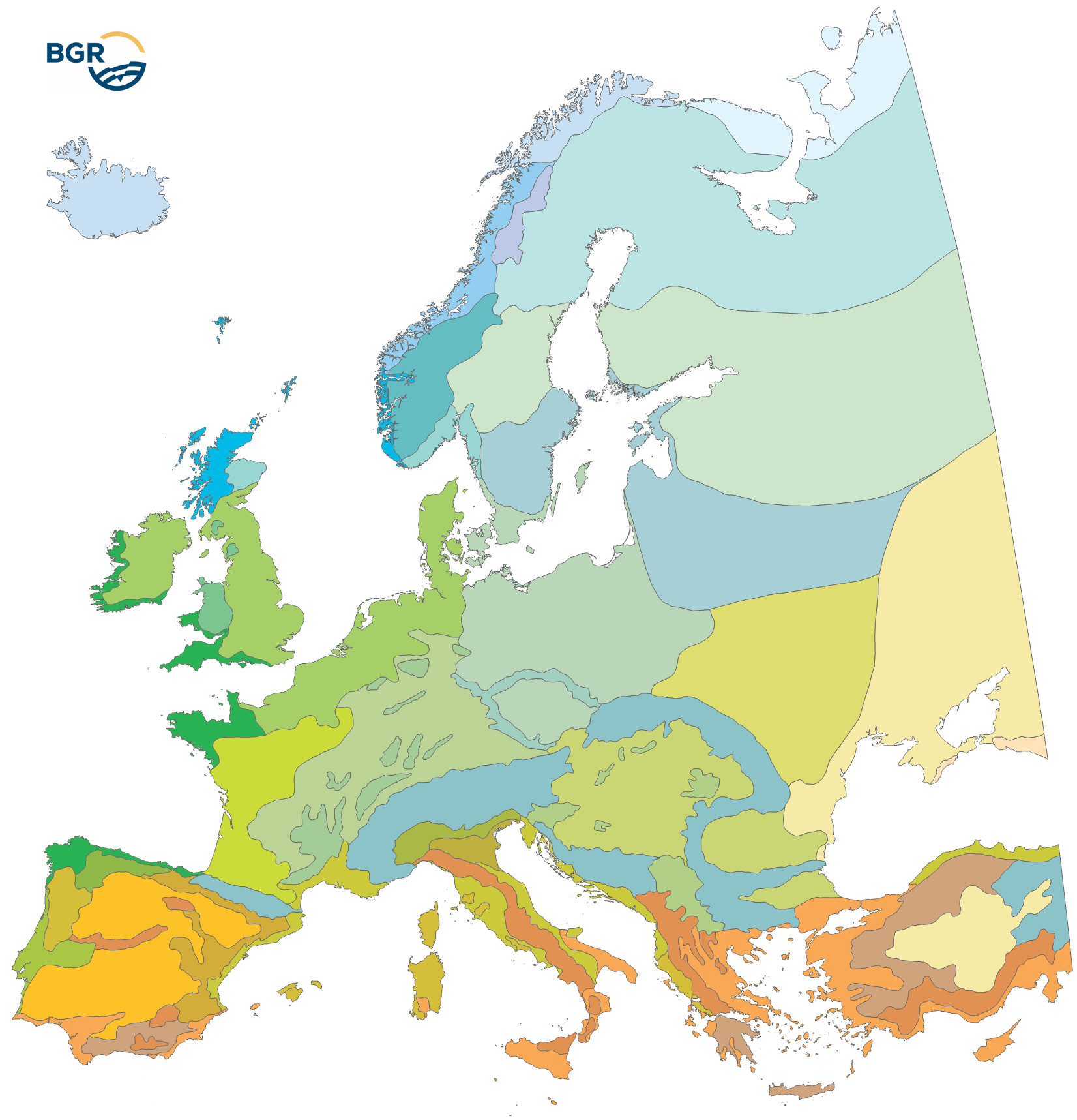
The Climatic Areas of Europe (EUCA15000) were delineated in order to stratify the legend of the European Soil Regions Map (EUSR5000). Because soil properties largely depend on climate, relief and geology, soil regions must be defined according to fairly homogenous macro-scale physiogeographic conditions. Because climate (and parent material) is the initial top level stratifier for the soil regions, its delineation is more coarsely defined. The EUCA15000 is mainly based on the Thermal Climate Classification (FAO 2004), which also has been used as a data source for the Global Agro-Ecological Zones (AEZ). Currently, the map distinguishes (i) the climate zones from North to South and (ii) the climate types with oceanic to continental influence. All in all, 35 climatic areas are delineated. They differ regarding mean annual temperatures, mean annual precipitation and the length of the growing period. Die Klimazonen Europas (EUCA15000) dienen dazu, die Legende der Europäischen Bodenregionenkarte (EUSR5000) zu strukturieren. Da die Bodeneigenschaften weitgehend vom Klima, Relief und der Geologie abhängen, müssen die Bodenregionen nach relativ homogenen makroskopischen und physiogeografischen Bedingungen definiert werden. Da das Klima (und das Ausgangsmaterial) die oberste Stratifizierungsebene für die Bodenregionen darstellt, ist seine Abgrenzung gröber definiert. Die EUCA15000 basiert hauptsächlich auf der thermischen Klimaklassifikation (FAO 2004), die auch als Datenquelle für die globalen agroökologischen Zonen (AEZ) verwendet wurde. Derzeit unterscheidet die Karte (i) die Klimazonen von Nord nach Süd und (ii) die Klimatypen mit ozeanischem bis kontinentalem Einfluss. Insgesamt werden 35 Klimazonen abgegrenzt. Sie unterscheiden sich hinsichtlich der mittleren Jahrestemperaturen, der mittleren jährlichen Niederschlagsmenge und der Länge der Vegetationsperiode.
Raumbezug
Lage der Geodaten (in WGS84)
| SW Länge/Breite | NO Länge/Breite | |
|---|---|---|
| -35.181°/31.886° | 67.021°/74.147° |
| Koordinatensystem |
|---|
Verweise und Downloads
Downloads (3)
Nutzung
| Nutzungsbedingungen |
General Standard Terms and Conditions (GSTC) of the Federal Institute for Geosciences and Natural Resources (BGR). The LBEG or the BGR is the owner of the rights of exploitation for software, digital data, and other products protected by copyright, as well as know-how. The contractual partner receives a simple right of use for the types of use defined in the following. The right to duplicate and present is also transferred. The rights which are not transferred include in particular the right to make accessible to the public, unless the contractual partner makes the aforementioned accessible to the public within the framework of an administrative procedure when acting as a participating authority in said administrative procedure. For the purpose of reuse the provided information has to be quoted as follows: BGR [Bundesanstalt für Geowissenschaften und Rohstoffe] (2005). Soil Regions Map of the European Union and Adjacent Countries 1:5,000,000 (Version 2.0). Special Publication, Ispra. EU catalogue number S.P.I.05.134. |
|---|
| Zugriffsbeschränkungen |
no limitations to public access |
|---|
Kontakt
Fachinformationen
Informationen zum Datensatz
| Identifikator |
48cc976c-ac43-57f8-be08-df324ee4d2f7 |
|---|
| Digitale Repräsentation |
Vector |
|---|
Erstellungsmaßstab
| Maßstab 1:x |
15000000 |
|---|
| Fachliche Grundlage |
Die Datenquellen sind in Hartwich et al. (2005) gelistet und erläutert: - Europaweite thematische Karten und Datensätze - Nationale/regionale Bodenkarten und Expertenwissen von Mitgliedern des European Soil Bureau Network (ESBN) - The data sources are listed, explained and cited in Hartwich et al. (2005): - Europe-wide thematic maps and data sets - national/regional soil maps and expert knowledge from members of the European Soil Bureau Network (ESBN) |
|---|
Informationen zum Metadatensatz
| Objekt-ID |
fb02933b-43e3-4bcf-a663-cfb16a7cf926 |
|---|
| Aktualität der Metadaten |
11.09.2025 |
|---|
| Sprache Metadatensatz |
Englisch |
|---|
| Datensatz / Datenserie |
Dataset |
|---|
| XML Darstellung |
|---|
| Point of Contact (Metadatum) |
|---|
| Metadatenquelle |
GeoDaK (Datenkatalog der Bundesanstalt für Geowissenschaften und Rohstoffe)
|
|---|---|
|
Bundesanstalt für Geowissenschaften und Rohstoffe
|


