Suche Karten Messwerte Kataloge Über NUMIS Anbieter Datenquellen API
Hilfe Kontakt Inhalt Impressum Datenschutz Barrierefreiheit
NUMIS - Das niedersächsische Umweltportal NUMIS - Das niedersächsische Umweltportal
Suche
Karten
Messwerte
Kataloge
API
Alle Suchergebnisse
Geodatensatz

Processed seismic data of Cruise BGR84 1984

Inhalt
  • Übersicht
  • Be­schrei­bung
    Aktualität des Datensatzes
  • Raumbezug
  • Verweise und Downloads
    Downloads Weitere Verweise
  • Nutzung
  • Kontakt
    Point of Contact
  • Fach­informationen
    Informationen zum Datensatz Zusatzinformationen Schlag­worte
  • Metadatensatz

Downloads (1)

BGR84 1984 (Shapefile) BGR84 1984 im Format ESRI Shape [2.0 MB]

Nutzungs­bedingun­gen

Allgemeine Geschäftsbedingungen, siehe http://www.bgr.bund.de/AGB - General terms and conditions, see http://www.bgr.bund.de/AGB_en. Die bereitgestellten Informationen sind bei Weiterverwendung wie folgt zu zitieren: Datenquelle: BGR84 1984, (c) BGR, Hannover, 2019

Point of Contact

Federal Institute for Geosciences and Natural Resources

Marine_Seismik@bgr.de

Vorschau

img

Be­schrei­bung

BGR84 1984

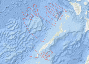
In the southwestern part of the Sulu Sea and in the southeastern part of the South China Sea, between NW Palawan and the northwestern part of the Reed Bank the Federal Institute for Geosciences and Natural Resources (BGR), Hannover carried out the geophysical survey BGR84 from 11th October, 1984 to 23rd November, 1984. This work was done in close cooperation with the Bureau of Mines and Geosciences (BMG), Manila, using the German seismic vessel EXPLORA chartered from PRAKLA-SEISMOS GmbH, Hannover. Multichannel reflection seismic measurements were carried out on 40 lines with a total length of 4,467 km simultaneously with magnetic measurements on 19 lines with a total length of 3,047 km. The Oligocene to lower Miocene Nido-carbonates of the South China Sea that have been proven during the SONNE cruises SO-23 and SO-27 beneath the allochthonous and chaotically deformed complex which was overthrusted from the Sulu Sea terrane, could be correlated up to the Balabac Straits. The three major unconformities of the Sulu Sea, unconformity A (Early Pliocene), unconformity B (mid Middle Miocene) and unconformity C (lower Middle Miocene) have been correlated over extensive areas by tying into the Sulu Sea well Coral-1. In the Sulu Sea reflection horizon C forms the top of a chaotic bedded rock complex and presumably represents an equivalent to the unconformity "Red" of the South China Sea, in the west of Palawan. There, the unconformity "Red" forms the surface of a highly deformed rock complex which has been interpreted as an allochthonous mass accumulation (HINZ, 1983; HINZ & SCHLÜTER, 1985). It is assumed that pronounced magnetic anomalies, approximately 140 - 160 km off NW Palawan as well as a change in the reflection seismic pattern of the acoustic basement, associated with diapiric structures which are interpreted as intrusions represent the ocean-continent boundary in this part of the South China Sea. In the Reed Bank area the basement type which is interpreted as continental crust (transitional crust?) extends as far as 160 km to the northwest, towards the South China Sea Basin. The northern part of the Reed Bank is characterized by intense downfaulting and rotated fault blocks with reef complexes ontop. In contrast to results from the Dangerous Grounds of the previous SONNE cruises, the deeper lying coherent reflections could be recognized in the monitor records off the northwestern Reed Bank area. It might be that these parts of the Reed Bank block consists of metamorphized and/or highly consolidated rocks of pre-Tertiary age which originally formed part of the Chinese back country, and which was effected by previous orogenies prior to the rifting of the proto-China continental margin. Auf der EXPLORA-Fahrt BGR84 sind in der Zeit vom 11. Oktober bis zum 23. November 1984 im südwestlichen Teil der Sulu See und im südöstlichen Teil des Südchinesischen Meeres, zwischen NW Palawan und der nordwestlichen Reed Bank, 40 Profile mit einer Gesamtlänge von 4.467 km mit digitaler Reflexionsseismik und 19 Profilen von insgesamt 3.047 km Länge mit Magnetik vermessen worden. Die während der SONNE-Fahrten SO-23 und SO-27 nachgewiesene oligozäne-untermiozäne Karbonatplattform des Südchinesischen Meeres mit Riffstrukturen vom Nido-Typ ist unter dem von Südosten aufgeschobenen, allochthonen Komplex aus chaotisch gelagerten Gesteinen der Sulu-See bis unter die Balabac-Straße zu verfolgen. Durch Überfahren der Sulu-See-Bohrung Coral-1 ist es möglich, die drei Hauptunkonformitäten A (frühes Pliozän), B (mittleres Mittelmiozän) und C (frühes Mittelmiozän) in den seismischen Registrierungen aus der Sulu-See über große Strecken zu korrelieren. Reflexionshorizont C der Bohrung Coral-1 bildet in der Sulu-See die Oberkante einer chaotisch gelagerten Gesteinsfolge und könnte das Äquivalent der Unkonformität "Rot" im Südchinesischen Meer, westlich von Palawan, sein. Die Unkonformität "Rot" bildet dort den Top eines ebenfalls stark deformierten Gesteinskomplexes mit chaotischen Lagerungsverhältnissen, der als allochthone Gesteinsakkumulation gedeutet wird (HINZ, 1983; HINZ & SCHLÜTER, 1985). Markante Änderungen im Reflexionsmuster des akustischen Basements, assoziiert mit diapirähnlichen und als Intrusionen gedeutete Strukturen sowie starke magnetische Anomalien im Südchinesischen Meer, etwa 140 - 180 km vor NW Palawan markieren vermutlich die Grenze zwischen kontinentaler und ozeanischer Kruste. Im Gebiet der Reed Bank setzt sich der als kontinentale Kruste (Übergangskruste?) gedeutete Basementtyp um etwa weitere 150 km nach Nordwesten in das Südchinesische Tiefseebecken fort. Der Nord- und Nordwestteil der Reed Bank ist durch intensive Blocktektonik mit seewärts gekippten Einzelschollen gekennzeichnet, die von Riffen überwachsen sind. Im Unterschied zu den Resultaten der SONNE-Fahrten von den Dangerous Grounds fehlen im Gebiet der norwestlichen Reed Bank tiefere, korrelierbare Reflexionshorizonte fast vollständig. Da diese Gebiete vor der Trennung vom proto-chinesischen Kontinentalrand durch Rifting Bestandteil des chinesischen Hinterlandes bildeten, könnte der Sockel der nördlichen Reed Bank aus metamorphen resp. aus hochkonsolidierten prätertiären Gesteinen bestehen, die keine markanten Impedanzunterschiede aufweisen.

Aktualität des Datensatzes

Creation

23.11.1984

Status

completed

Raumbezug

Lage der Geodaten (in WGS84)
SW Länge/Breite NO Länge/Breite
115.403°/7.382° 120.071°/13.501°
Koordinaten­system
EPSG:4326

Verweise und Downloads

Downloads (1)

BGR84 1984 (Shapefile) BGR84 1984 im Format ESRI Shape [2.0 MB]

Weitere Verweise (34)

http://www.geo-seas.eu/v_cdi_v3/print_ajax.asp?n_code=1299171 Information Profile BGR84-01
http://www.geo-seas.eu/v_cdi_v3/print_ajax.asp?n_code=1299172 Information Profile BGR84-02
http://www.geo-seas.eu/v_cdi_v3/print_ajax.asp?n_code=1299173 Information Profile BGR84-03
http://www.geo-seas.eu/v_cdi_v3/print_ajax.asp?n_code=1299174 Information Profile BGR84-04
http://www.geo-seas.eu/v_cdi_v3/print_ajax.asp?n_code=1299175 Information Profile BGR84-05
http://www.geo-seas.eu/v_cdi_v3/print_ajax.asp?n_code=1299176 Information Profile BGR84-06
http://www.geo-seas.eu/v_cdi_v3/print_ajax.asp?n_code=1299177 Information Profile BGR84-07
http://www.geo-seas.eu/v_cdi_v3/print_ajax.asp?n_code=1299178 Information Profile BGR84-08
http://www.geo-seas.eu/v_cdi_v3/print_ajax.asp?n_code=1299179 Information Profile BGR84-09
http://www.geo-seas.eu/v_cdi_v3/print_ajax.asp?n_code=1299180 Information Profile BGR84-10
http://www.geo-seas.eu/v_cdi_v3/print_ajax.asp?n_code=1299181 Information Profile BGR84-101
http://www.geo-seas.eu/v_cdi_v3/print_ajax.asp?n_code=1299182 Information Profile BGR84-102
http://www.geo-seas.eu/v_cdi_v3/print_ajax.asp?n_code=1299183 Information Profile BGR84-103
http://www.geo-seas.eu/v_cdi_v3/print_ajax.asp?n_code=1299184 Information Profile BGR84-104
http://www.geo-seas.eu/v_cdi_v3/print_ajax.asp?n_code=1299185 Information Profile BGR84-105
http://www.geo-seas.eu/v_cdi_v3/print_ajax.asp?n_code=1299186 Information Profile BGR84-106
http://www.geo-seas.eu/v_cdi_v3/print_ajax.asp?n_code=1299187 Information Profile BGR84-107
http://www.geo-seas.eu/v_cdi_v3/print_ajax.asp?n_code=1299188 Information Profile BGR84-109
http://www.geo-seas.eu/v_cdi_v3/print_ajax.asp?n_code=1299189 Information Profile BGR84-111
http://www.geo-seas.eu/v_cdi_v3/print_ajax.asp?n_code=1299190 Information Profile BGR84-112
http://www.geo-seas.eu/v_cdi_v3/print_ajax.asp?n_code=1299191 Information Profile BGR84-113
http://www.geo-seas.eu/v_cdi_v3/print_ajax.asp?n_code=1299192 Information Profile BGR84-115
http://www.geo-seas.eu/v_cdi_v3/print_ajax.asp?n_code=1299193 Information Profile BGR84-116
http://www.geo-seas.eu/v_cdi_v3/print_ajax.asp?n_code=1299194 Information Profile BGR84-118
http://www.geo-seas.eu/v_cdi_v3/print_ajax.asp?n_code=1299195 Information Profile BGR84-119
http://www.geo-seas.eu/v_cdi_v3/print_ajax.asp?n_code=1299196 Information Profile BGR84-120
http://www.geo-seas.eu/v_cdi_v3/print_ajax.asp?n_code=1299197 Information Profile BGR84-121B
http://www.geo-seas.eu/v_cdi_v3/print_ajax.asp?n_code=1299198 Information Profile BGR84-121
http://www.geo-seas.eu/v_cdi_v3/print_ajax.asp?n_code=1299199 Information Profile BGR84-123
http://www.geo-seas.eu/v_cdi_v3/print_ajax.asp?n_code=1299200 Information Profile BGR84-124
http://www.geo-seas.eu/v_cdi_v3/print_ajax.asp?n_code=1299201 Information Profile BGR84-125
http://www.geo-seas.eu/v_cdi_v3/print_ajax.asp?n_code=1299202 Information Profile BGR84-126
http://www.geo-seas.eu/v_cdi_v3/print_ajax.asp?n_code=1299203 Information Profile BGR84-129
https://services.bgr.de/geophysik/mssp Information Karte im BGR-Geoviewer
Identifikator des über­geordneten Metadaten­satzes

06a73c56-06a2-40d8-b806-466222b0760d

Nutzung

Nutzungs­bedingun­gen

Allgemeine Geschäftsbedingungen, siehe http://www.bgr.bund.de/AGB - General terms and conditions, see http://www.bgr.bund.de/AGB_en. Die bereitgestellten Informationen sind bei Weiterverwendung wie folgt zu zitieren: Datenquelle: BGR84 1984, (c) BGR, Hannover, 2019

Zugriffs­beschränkun­gen

no limitations to public access

Kontakt

Point of Contact

Federal Institute for Geosciences and Natural Resources

Stilleweg 2
30655 Hannover

Marine_Seismik@bgr.de

Fach­informationen

Informationen zum Datensatz

Identifikator

c627e620-93bd-93a4-44ca-7807d83d87cc

Digitale Repräsentation

Vector

Fachliche Grundlage

In the period from 11th October to 23rd November 1984 BGR acquired seismic lines in the southwestern part of the Sulu Sea and in the southeastern part of the South China Sea during cruise BGR84 with SV EXPLORA. The lines BGR84-108, BGR84-109B, BGR84-110, BGR84-114, BGR84-117, BGR84-122, BGR84-127, BGR84-128 and BGR84-130 consist of raw data. The lines BGR84-112, BGR84-116, BGR84-118, BGR84-120, BGR84-121, BGR84-121B, BGR84-126 and BGR84-129 consist of near trace measurements. The lines BGR84-01, BGR84-02, BGR84-03, BGR84-04, BGR84-05, BGR84-06, BGR84-07, BGR84-08, BGR84-09, BGR84-10, BGR84-101, BGR84-102, BGR84-103, BGR84-104, BGR84-105, BGR84-106, BGR84-107, BGR84-109 and BGR84-123 are stacked data. The lines BGR84-111, BGR84-113, BGR84-115, BGR84-119, BGR84-124 and BGR84-125 are migrated data.

Zusatzinformationen

Sprache des Daten­satzes

Englisch

Kon­formi­tät
Spezifi­kation der Kon­formi­tät Spezifi­kations­datum Grad der Kon­formi­tät Geprüft mit
VERORDNUNG (EG) Nr. 1089/2010 DER KOMMISSION vom 23. November 2010 zur Durchführung der Richtlinie 2007/2/EG des Europäischen Parlaments und des Rates hinsichtlich der Interoperabilität von Geodatensätzen und -diensten 08.12.2010 siehe dazu die angegebene Durchführungsbestimmung
Datenformat
Name Version Kompressionstechnik Spezifi­kation
Shapefile n/a

Schlag­worte

INSPIRE-Themen Geology
GEMET-Concepts geophysics Geophysik raw material Rohstoff
ISO-Themen­kategorien Geoscientific Information
Suchbegriffe Marine geology Meeresgeologie Palawan Reed Bank Seismics Seismik South China Sea Sulu Sea Sulu-See Südchinesisches Meer Two-dimensional seismic reflection zweidimensionale Reflektionsseismik

Informationen zum Metadatensatz

Objekt-ID

f0420782-e89a-4bac-9a27-d569be4ff5a6

Aktualität der Metadaten

16.11.2023

Sprache Metadatensatz

Englisch

Datensatz / Datenserie  

Dataset

XML Dar­stellung
Metadaten als XML herunter­laden
Point of Contact (Metadatum)
geodatenmanagement@bgr.de
Metadatenquelle
GeoDaK (Datenkatalog der Bundesanstalt für Geowissenschaften und Rohstoffe)
Bundesanstalt für Geowissenschaften und Rohstoffe

NUMIS - Das niedersächsische Umweltportal
Niedersächsisches Ministerium für Umwelt,
Energie und Klimaschutz
Hilfe Kontakt Inhalt Impressum Datenschutz Barrierefreiheit
Nach oben

Hilfe

NUMIS NUMIS
UVP UVP