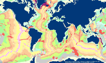
The General Global Map of Seafloor Bedrock Geology (seafloorgeol) shows the global distribution of seafloor bedrock, the boundaries of the continental shelf and continental slope, the axes of the oceanic ridges and other marine geological features. Sedimentary deposits are not shown. The map is based on extracts from Bouysse et al. (2010) © CGMW, and Bryan & Ernst (2008) using Esri Basemap, HERE, Garmin, FAO, NOAA, USGS, © OpenStreetMap contributors and the GIS User Community. Die Übersichtskarte der Geologie des Meeresbodens weltweit (seafloorgeol) zeigt die weltweite Verbreitung der Festgesteine des Meeresbodens, den Ozeanischen Rücken, die Grenzen der Festlandsockel und Kontinentalabhänge, sowie weitere geologische off-shore Merkmale. Sedimentäre Ablagerungen sind nicht dargestellt. Die Karte basiert auf Auszügen aus Bouysse et al. (2010) © CGMW, sowie Bryan & Ernst (2008) unter Nutzung der Esri Basemap, HERE, Garmin, FAO, NOAA, USGS, © OpenStreetMap contributors and the GIS User Community.
Raumbezug
Lage der Geodaten (in WGS84)
| SW Länge/Breite | NO Länge/Breite | |
|---|---|---|
| -180.0°/-90.0° | 180.0°/90.0° |
| Koordinatensystem |
|---|
Verweise und Downloads
Querverweise (1)
WMS
Geodatendienst
General Global Map of Seafloor Bedrock Geology (seafloorgeol) (WMS)
The General Global Map of Seafloor Bedrock Geology (seafloorgeol) shows the global distribution of seafloor bedrock, the boundaries of the continental shelf and continental slope, the axes of the oceanic ridges and other marine geological features. Sedimentary deposits are not shown. The map is based on extracts from Bouysse et al. (2010) © CGMW, and Bryan & Ernst (2008) using Esri Basemap, HERE, Garmin, FAO, NOAA, USGS, © OpenStreetMap contributors and the GIS User Community.
Kartenansicht öffnen
Weitere Verweise (1)
https://services.bgr.de/geologie/seafloorgeol
Information
Karte im BGR-Geoviewer
Nutzung
| Nutzungsbedingungen |
Allgemeine Geschäftsbedingungen, s. https://www.bgr.bund.de/agb - General Terms and Conditions, s. https://www.bgr.bund.de/agb_en |
|---|
| Zugriffsbeschränkungen |
no limitations to public access |
|---|
Kontakt
Fachinformationen
Informationen zum Datensatz
| Identifikator |
81cdde56-db4e-a35a-ff3f-dce6053cd3ba |
|---|
| Digitale Repräsentation |
Vector |
|---|
Erstellungsmaßstab
| Maßstab 1:x |
70000000 |
|---|
| Fachliche Grundlage |
Map based on extracts from Bouysse et al. (2010) © CGMW, and Bryan & Ernst (2008), using the Esri Basemap, HERE, Garmin, FAO, NOAA, USGS, © OpenStreetMap contributors and the GIS User Community Bouysse, P. et al (2010): Geological Map of the World. Commission of the Bryan, S. E. and Ernst R. E., 2008. Revised definition of Large Igneous Provinces (LIPs), Elsevier, Earth Science Review 86 |
|---|
Zusatzinformationen
| Sprache des Datensatzes |
Deutsch |
|---|
Konformität
| Spezifikation der Konformität | Spezifikationsdatum | Grad der Konformität | Geprüft mit |
|---|---|---|---|
| VERORDNUNG (EG) Nr. 1089/2010 DER KOMMISSION vom 23. November 2010 zur Durchführung der Richtlinie 2007/2/EG des Europäischen Parlaments und des Rates hinsichtlich der Interoperabilität von Geodatensätzen und -diensten | 08.12.2010 | siehe dazu die angegebene Durchführungsbestimmung |
Datenformat
| Name | Version | Kompressionstechnik | Spezifikation |
|---|---|---|---|
| WMS | 1.3.0 |
Informationen zum Metadatensatz
| Objekt-ID |
eced4cf0-b4f4-48bb-8f82-37c0f5a33311 |
|---|
| Aktualität der Metadaten |
20.01.2025 |
|---|
| Sprache Metadatensatz |
Englisch |
|---|
| Datensatz / Datenserie |
Dataset |
|---|
| XML Darstellung |
|---|
| Point of Contact (Metadatum) |
|---|
| Metadatenquelle |
GeoDaK (Datenkatalog der Bundesanstalt für Geowissenschaften und Rohstoffe)
|
|---|---|
|
Bundesanstalt für Geowissenschaften und Rohstoffe
|


