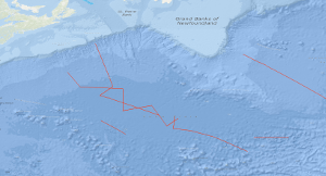
In the time from 13th August to 13th September, 1989 a geophysical survey was carried out with S.V. PROSPEKTA in the Southeastern Newfoundland Basin and in the Sohm Abyssal Plain. Sixteen multichannel seismic lines with a total length of 3,568 km were surveyed. The general aim of the survey was to study the structure of the oceanic crust formed during the period from 150 to 80 m.y.B.P.. The results we found that the magmatic-volcanic activity at the Mesozoic Atlantic spreading center was episodic, and there was some form of magmatic-tectonic cycling in the Mid-Atlantic Ridge processes. Drastic changes of the oceanic crustal structure have been observed, and a volcanic basement unit characterized by an internally divergent pattern of reflection horizons having an eastward dip was found coinciding with magnetic anomalies M-4 to M-0. This body consists probably of basaltic flows and volcanic clastic rocks extruded near or above sea level, and it appears that this unit is continuous from the Eastern Newfoundland Basin to the New England Seamount Chain. A doubling of the oceanic crustal thickness occurs around M-10 and is present in the area of the young end of the series of magnetic M-anomalies. Doubling of the thickness of the oceanic crust is also present in the conjugate eastern central North Atlantic segment in the area of magnetic anomalies M-10 to about M-0. In der Zeit vom 13. August bis 13. September 1989 sind digitale reflexionsseismische Messungen mit S.V. PROSPEKTA im SE-Neufundlandbecken und in der Sohm-Tiefsee-Ebene ausgeführt worden. Es sind 16 Profile mit einer Gesamtlänge von 3.568 km vermessen worden. Das wissenschaftliche Ziel der Fahrt war, Bau und Struktur der ozeanischen Kruste zu untersuchen, die im Zeitraum vor 150 Mill. - 80 Mill. Jahren gebildet worden ist. Die Messungen zeigen, dass die magmatisch-vulkanische Aktivität am mesozoischen, mittelatlantischen Rücken episodisch war und mit Phasen nicht-magmatischer Krustendehnung abwechselte. Wir haben nicht nur markante Änderungen in der ozeanischen Krustenstruktur beobachtet, sondern auch einen basaltischen Extrusivkomplex, der durch ein divergentes und seewärts einfallendes Schichtungsmuster ausgezeichnet ist. Diese subaerisch angelegte Einheit erstreckt sich offenbar vom östlichen Neufundland-Becken bis zu den Neuengland-Kuppen und liegt im Gebiet der magnetischen Anomalien M-4 bis M-0. Eine Verdickung der ozeanischen Kruste existiert im Gebiet der magnetischen Anomalien M-10 bis M-0. Im konjugierenden Segment des östlichen zentralen Nordatlantiks ist auch eine Verdopplung der Mächtigkeit der ozeanischen Kruste im Gebiet der magnetischen Anomalien M-10 bis M-0 von uns erkannt worden.
Raumbezug
Lage der Geodaten (in WGS84)
| SW Länge/Breite | NO Länge/Breite | |
|---|---|---|
| -60.397°/36.0° | -41.807°/43.768° |
| Koordinatensystem |
|---|
Verweise und Downloads
Weitere Verweise (17)
http://www.geo-seas.eu/v_cdi_v3/print_ajax.asp?n_code=1399441
Information
Profile BGR89-01
http://www.geo-seas.eu/v_cdi_v3/print_ajax.asp?n_code=1399442
Information
Profile BGR89-02
http://www.geo-seas.eu/v_cdi_v3/print_ajax.asp?n_code=1399443
Information
Profile BGR89-03
http://www.geo-seas.eu/v_cdi_v3/print_ajax.asp?n_code=1399444
Information
Profile BGR89-04
http://www.geo-seas.eu/v_cdi_v3/print_ajax.asp?n_code=1399445
Information
Profile BGR89-05
http://www.geo-seas.eu/v_cdi_v3/print_ajax.asp?n_code=1399446
Information
Profile BGR89-06
http://www.geo-seas.eu/v_cdi_v3/print_ajax.asp?n_code=1399447
Information
Profile BGR89-07
http://www.geo-seas.eu/v_cdi_v3/print_ajax.asp?n_code=1399448
Information
Profile BGR89-08
http://www.geo-seas.eu/v_cdi_v3/print_ajax.asp?n_code=1399449
Information
Profile BGR89-09
http://www.geo-seas.eu/v_cdi_v3/print_ajax.asp?n_code=1399450
Information
Profile BGR89-10
http://www.geo-seas.eu/v_cdi_v3/print_ajax.asp?n_code=1399451
Information
Profile BGR89-11
http://www.geo-seas.eu/v_cdi_v3/print_ajax.asp?n_code=1399452
Information
Profile BGR89-12
http://www.geo-seas.eu/v_cdi_v3/print_ajax.asp?n_code=1399453
Information
Profile BGR89-13
http://www.geo-seas.eu/v_cdi_v3/print_ajax.asp?n_code=1399454
Information
Profile BGR89-14
http://www.geo-seas.eu/v_cdi_v3/print_ajax.asp?n_code=1399455
Information
Profile BGR89-15
http://www.geo-seas.eu/v_cdi_v3/print_ajax.asp?n_code=1399456
Information
Profile BGR89-16
https://services.bgr.de/geophysik/mssp
Information
Karte im BGR-Geoviewer
| Identifikator des übergeordneten Metadatensatzes |
06a73c56-06a2-40d8-b806-466222b0760d |
|---|
Nutzung
| Nutzungsbedingungen |
Allgemeine Geschäftsbedingungen, siehe http://www.bgr.bund.de/AGB - General terms and conditions, see http://www.bgr.bund.de/AGB_en. Die bereitgestellten Informationen sind bei Weiterverwendung wie folgt zu zitieren: Datenquelle: BGR89 MESOC 1989, (c) BGR, Hannover, 2018 |
|---|
| Zugriffsbeschränkungen |
no limitations to public access |
|---|
Kontakt
Fachinformationen
Informationen zum Datensatz
| Identifikator |
55787628-d2ba-dc1e-6cbf-24e814688b2c |
|---|
| Digitale Repräsentation |
Vector |
|---|
| Fachliche Grundlage |
During the period from 13th August 1989 to 13th September 1989 BGR acquired seismic lines in the Northwest Atlantic Ocean off Newfoundland. The line BGR89-01 consists of stacked data. The lines BGR89-02 to BGR89-16 are migrated data. |
|---|
Zusatzinformationen
| Sprache des Datensatzes |
Englisch |
|---|
Konformität
| Spezifikation der Konformität | Spezifikationsdatum | Grad der Konformität | Geprüft mit |
|---|---|---|---|
| VERORDNUNG (EG) Nr. 1089/2010 DER KOMMISSION vom 23. November 2010 zur Durchführung der Richtlinie 2007/2/EG des Europäischen Parlaments und des Rates hinsichtlich der Interoperabilität von Geodatensätzen und -diensten | 08.12.2010 | siehe dazu die angegebene Durchführungsbestimmung |
Datenformat
| Name | Version | Kompressionstechnik | Spezifikation |
|---|---|---|---|
| Shapefile | n/a |
Schlagworte
| INSPIRE-Themen | Geology |
| GEMET-Concepts | geophysics Geophysik raw material Rohstoff |
| ISO-Themenkategorien | Geoscientific Information |
| Suchbegriffe | Marine geology Meeresgeologie Neufundland-Becken Newfoundland Basin Nordwest-Atlantik Northwest Atlantic Ocean Seismics Seismik Sohm Abyssal Plain Sohm-Tiefsee-Ebene |
Informationen zum Metadatensatz
| Objekt-ID |
8f1b8ee3-ab66-4f01-9199-1aeff1136320 |
|---|
| Aktualität der Metadaten |
14.11.2023 |
|---|
| Sprache Metadatensatz |
Englisch |
|---|
| Datensatz / Datenserie |
Dataset |
|---|
| XML Darstellung |
|---|
| Point of Contact (Metadatum) |
|---|
| Metadatenquelle |
GeoDaK (Datenkatalog der Bundesanstalt für Geowissenschaften und Rohstoffe)
|
|---|---|
|
Bundesanstalt für Geowissenschaften und Rohstoffe
|


