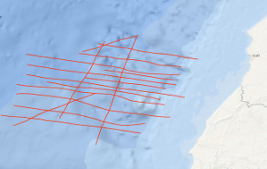
During METEOR-Westafrica cruise 46, leg 1, geophysical measurements were carried out off Morocco between 31°30'N and 32°30'N in the time period from the 8th October to the 5th November 1977. Altogether 1,855 km of 24-fold reflection seismic data were collected on lines ME46-02 to ME46-11 and on lines ME46-14 to ME46-19. For the purpose of planning the programme, the reflection seismic data were processed (12-fold stack) aboard. 3,465 km of magnetic, gravimetric and bathymetric data were collected on lines ME46-01 to ME46-26 using the new BGR digital recording system. Along lines ME46-101 and ME46-102 with a total length of 209 km refraction seismic measurements were carried out with 6 moored telemetric buoys. A total of 164 shots with charges of 5 kg up to 200 kg were fired along the two lines in distances of about 1.5 km. A distinct fault zone was discovered in the area of investigation which is associated with a positive magnetic anomaly. The fault zone strikes NNE-SSW and probably marks the ocean-continent boundary. Beside diapiric structures (salt) allochthonous structures - thrust structures - are widespread features east of the discovered fault zone and below the lower continental slope. The seismic data indicate that the evolution of the old continental margin of the East Atlantic was also controlled by large scale gravity tectonics. Auf dem ersten Fahrtabschnitt der METEOR-Westafrika-Fahrt 1977, Reise Nr. 46, sind am Kontinentalrand vor Marokko (31°30'N bis 32°30'N) in der Zeit vom 08.10.77 bis zum 04.11.1977 1.855 Profilkilometer auf den Profilen ME46-01 bis ME46-11 und ME46-14 bis ME46-19 reflexionsseismisch mit einem 24-spurigen digitalseismischen Messsystem untersucht und die gesamten Messdaten so aufbereitet worden, dass kurz nach der Aufnahme interpretierbare seismische Sektionen vorlagen. 3.465 Profilkilometer auf den Linien ME46-01 bis ME46-26 sind gravimetrisch, magnetisch und bathymetrisch mit dem neuen BGR-Datenerfassungssystem digital vermessen worden. 209 km sind refraktionsseismisch mit insgesamt 6 verankerten telemetrischen Bojenmesssystemen auf den Profilen ME46-101 und ME46-102 untersucht worden. Dafür sind 164 Ladungen von 5 kg bis 200 kg gezündet und insgesamt 12.000 kg Sprengstoff vernichtet worden. Es ist eine bedeutende, mit einer magnetischen Anomalie einhergehende Störungszone entdeckt worden, die im Untersuchungsgebiet NNE-SSW streicht und wahrscheinlich die Ozean-Kontinentgrenze markiert. Östlich der Störungszone sind neben Diapirstrukturen vor allem allochthone Strukturen weit verbreitet. Die Formung des ältesten Kontinentalrandes des östlichen Atlantiks ist entscheidend mit durch großräumige gravitative Tektonik geprägt worden.
Raumbezug
Lage der Geodaten (in WGS84)
| SW Länge/Breite | NO Länge/Breite | |
|---|---|---|
| -11.633°/31.466° | -9.757°/32.512° |
| Koordinatensystem |
|---|
Verweise und Downloads
| Identifikator des übergeordneten Metadatensatzes |
06a73c56-06a2-40d8-b806-466222b0760d |
|---|
Nutzung
| Nutzungsbedingungen |
Allgemeine Geschäftsbedingungen, siehe http://www.bgr.bund.de/AGB - General terms and conditions, see http://www.bgr.bund.de/AGB_en. Die bereitgestellten Informationen sind bei Weiterverwendung wie folgt zu zitieren: Datenquelle: ME46 1977, (c) BGR, Hannover, 1977 |
|---|
| Zugriffsbeschränkungen |
no limitations to public access |
|---|
Kontakt
Fachinformationen
Informationen zum Datensatz
| Identifikator |
ab6cf89b-95bf-cfc6-93c8-6586f39bb455 |
|---|
| Digitale Repräsentation |
Vector |
|---|
| Fachliche Grundlage |
During the period from the 8th October to the 5th November 1977 BGR acquired seismic lines off Morocco. All lines ME46-02 to ME46-19 consist of raw data. |
|---|
Zusatzinformationen
| Sprache des Datensatzes |
Englisch |
|---|
Konformität
| Spezifikation der Konformität | Spezifikationsdatum | Grad der Konformität | Geprüft mit |
|---|---|---|---|
| VERORDNUNG (EG) Nr. 1089/2010 DER KOMMISSION vom 23. November 2010 zur Durchführung der Richtlinie 2007/2/EG des Europäischen Parlaments und des Rates hinsichtlich der Interoperabilität von Geodatensätzen und -diensten | 08.12.2010 | siehe dazu die angegebene Durchführungsbestimmung |
Datenformat
| Name | Version | Kompressionstechnik | Spezifikation |
|---|---|---|---|
| Shapefile | n/a |
Schlagworte
| INSPIRE-Themen | Geology |
| GEMET-Concepts | geophysics Geophysik raw material Rohstoff |
| ISO-Themenkategorien | Geoscientific Information |
| Suchbegriffe | Central East Atlantic Marine geology Marokko Meeresgeologie Morocco Seismics Seismik Two-dimensional seismic reflection Zentraler Ostatlantik zweidimensionale Reflektionsseismik |
Informationen zum Metadatensatz
| Objekt-ID |
6f5d7176-cb85-44ac-989e-79fa7a7dba6b |
|---|
| Aktualität der Metadaten |
14.11.2023 |
|---|
| Sprache Metadatensatz |
Englisch |
|---|
| Datensatz / Datenserie |
Dataset |
|---|
| XML Darstellung |
|---|
| Point of Contact (Metadatum) |
|---|
| Metadatenquelle |
GeoDaK (Datenkatalog der Bundesanstalt für Geowissenschaften und Rohstoffe)
|
|---|---|
|
Bundesanstalt für Geowissenschaften und Rohstoffe
|


