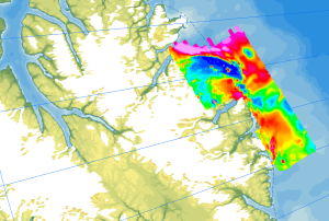
Onshore geological field work combined with an onshore/offshore aeromagnetic survey was carried out during a joint expedition of the German BGR and the Canadian GSC to understand the structural architecture of the North American continental margin. The helicopter-borne magnetic survey of 2008 covered the northern coastal areas of Ellesmere Island and the adjacent marine areas. The survey was conducted with a line separation of 2 km and covered a 40 to 50 km wide swath offshore about parallel to the north coast of Ellesmere Island from Yelverton Bay in the west to Parr Bay east of Cape Columbia, the northernmost point of Canada. Between Yelverton Bay and M'Clintock Inlet, the survey extended about 40 to 50 km inland, which was the prime target area of the CASE 11 geological investigations. This section of mountainous terrain was flown in a “draped” mode to keep the distance to ground at approximately 1500 ft, same as over the offshore areas. During a 4-weeks period in May/June 2008, close to 8000 km of aeromagnetic line data were acquired, covering an area of 12000 km². Im Rahmen der Expedition CASE 11 wurde parallel zu den geologischen Geländearbeiten eine Onshore-/Offshore-Befliegung in Kooperation mit dem kanadischen GSC durchgeführt, um den strukturellen Bau des Nordamerikanischen Kontinentalrands zu untersuchen. Die helikoptergestützte magnetische Befliegung im Jahr 2008 deckte die nördlichen Küstengebiete von Ellesmere Island und die angrenzenden Meeresgebiete ab. Die Vermessung wurde mit einem Fluglinienabstand von 2 km durchgeführt und umfasste einen 40 bis 50 km breiten Küstenstreifen von Ellesmere Island zwischen Yelverton Bay im Westen bis Parr Bay östlich von Cape Columbia, dem nördlichsten Punkt von Kanada. Zwischen Yelverton Bay und M'Clintock Inlet erstreckte sich die Vermessung etwa 40 bis 50 km landeinwärts in das Hauptzielgebiet der geologischen Untersuchungen von CASE 11. Dieser bergige Abschnitt wurde in einer konstanten Flughöhe zum Boden bei etwa 1500 Fuß überflogen, genau wie über den Offshore-Bereichen. Während eines 4-wöchigen Zeitraums im Mai/Juni 2008 wurden fast 8000 km aeromagnetische Liniendaten erfasst, die eine Fläche von 12000 km² abdecken.
Raumbezug
Lage der Geodaten (in WGS84)
| SW Länge/Breite | NO Länge/Breite | |
|---|---|---|
| -84.85°/81.92° | -67.94°/84.0° |
| Koordinatensystem |
|---|
Verweise und Downloads
Downloads (2)
AeromagCASE11 (GeoTIFF)
AeromagCASE11 im Format geoTiff
Flightlines (Shape)
Flightlines im Format Shape
Querverweise (1)
WMS
Geodatendienst
Helicopter-borne Magnetics in the Arctic region (WMS)
The study of the geodynamic evolution of the Arctic continental margin and opening of the Arctic Ocean represents a primary target of BGR research and is studied within the frame of the CASE programme. In addition to onshore geological investigations, BGR conducts airborne aeromagnetic surveys. The available service contains the results of aeromagnetic surveys from the CASE program as well as cooperation projects (PMAP, NARES & NOGRAM), which were obtained with helicopters or fixed-wing aircraft in the Arctic.
Kartenansicht öffnen
Weitere Verweise (2)
https://services.bgr.de/geophysik/aeromagarctic
Information
Karte im BGR-Geoviewer
https://www.bgr.bund.de/DE/Themen/Polarforschung/Arktis/arktis_node.html
Information
Arktisforschung der BGR
| Identifikator des übergeordneten Metadatensatzes |
e85d6dcc-91b8-48bc-a80d-7ca0f9546cda |
|---|
Nutzung
| Nutzungsbedingungen |
Allgemeine Geschäftsbedingungen, siehe https://www.bgr.bund.de/AGB - General terms and conditions, see https://www.bgr.bund.de/AGB_en. Die bereitgestellten Informationen sind bei Weiterverwendung wie folgt zu zitieren: Datenquelle: AeromagCASE11, (c) BGR, Hannover, 2023 |
|---|
| Zugriffsbeschränkungen |
no limitations to public access |
|---|
Kontakt
Fachinformationen
Informationen zum Datensatz
| Identifikator |
afb3116e-5c1b-4f53-a7a2-495aab80faf7 |
|---|
| Fachliche Grundlage |
The aeromagnetic data were jointly collected by GSC Canada and BGR as part of the CASE program during the CASE 11 expedition on Ellesmere Island. |
|---|
Zusatzinformationen
| Sprache des Datensatzes |
Englisch |
|---|
Datenformat
| Name | Version | Kompressionstechnik | Spezifikation |
|---|---|---|---|
| GeoTIFF | n/a | ||
| shp | n/a | ||
| WMS | OGC:WMS1.3.0 |
Schlagworte
| INSPIRE-Themen | Geology |
| GEMET-Concepts | Geophysik |
| ISO-Themenkategorien | Geoscientific Information |
| Suchbegriffe | Aerogeophysik Aeromagnetik Airborne geophysics Anomalien des erdmagnetischen Feldes anomalies of the Earth’s magnetic field Arctic Arktis Ellesmere Island helicopter-borne /fixed-wing magnetics Nordpolargebiet |
Informationen zum Metadatensatz
| Objekt-ID |
5aa4488e-f0cc-4edd-bedf-a2b9256c8107 |
|---|
| Aktualität der Metadaten |
07.04.2025 |
|---|
| Sprache Metadatensatz |
Englisch |
|---|
| Datensatz / Datenserie |
Dataset |
|---|
| XML Darstellung |
|---|
| Point of Contact (Metadatum) |
|---|
| Metadatenquelle |
GeoDaK (Datenkatalog der Bundesanstalt für Geowissenschaften und Rohstoffe)
|
|---|---|
|
Bundesanstalt für Geowissenschaften und Rohstoffe
|


