Suche Karten Messwerte Kataloge Über NUMIS Anbieter Datenquellen API
Hilfe Kontakt Inhalt Impressum Datenschutz Barrierefreiheit
NUMIS - Das niedersächsische Umweltportal NUMIS - Das niedersächsische Umweltportal
Suche
Karten
Messwerte
Kataloge
API
Alle Suchergebnisse
Geodatensatz

Marine geowissenschaftliche Daten - Projekt PANORAMA

Inhalt
  • Übersicht
  • Be­schrei­bung
    Aktualität des Datensatzes
  • Raumbezug
  • Verweise und Downloads
    Querverweise
  • Nutzung
  • Kontakt
    Ansprechpartner
  • Fach­informationen
    Informationen zum Datensatz Zusatzinformationen Schlag­worte
  • Metadatensatz

Querverweise (1)

WMS
Marine geowissenschaftliche Daten - Projekt PANORAMA (WMS)
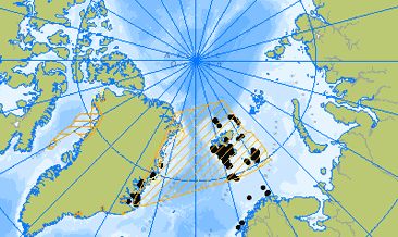
Im Rahmen des PANORAMA Projekts wurden vier marin-geophysikalische und marin geologische Expeditionen durchgeführt. 2013: Panorama1 mit dem Forschungsschiff RV OGS Explora, nördliche Barentssee und Eurasisches Becken; 2015: Panorama2 mit RV OGS Explora, nördliche Barentssee, Olga Becken; 2017 SEGMENT mit RV Maria S. Merian, nordöstlicher Kontinentrand Grönland; 2018 GREENMATE mit RV Polarstern, nordöstlicher und nördlicher Kontinentrand Grönland. Die geowissenschaftlichen Daten umfassen für die genannten Expeditionen 2D reflexionsseismische Daten und refraktionsseismische Daten (mit OBS bzw. Sonarboje. Zusätzlich wurden hydroakustische Daten mit den bordeigenen Fächerecholoten bzw. Sedimentecholoten aufgezeichnet. Darüber hinaus wurden gravimetrische und magnetische Daten erfasst. Geologische und geochemische Daten wurden mit Schwereloten und Multicorern genommen. Im Rahmen der Expedition Greenmate (2018) wurde auch per Helikopter Proben an der Küste NO Grönlands genommen. Ergebnisse stehen bislang in den folgenden Veröffentlichungen zur Verfügung: Berglar Kai, Franke Dieter, Lutz Rüdiger, Schreckenberger Bernd, Damm Volkmar; Initial Opening of the Eurasian Basin, Arctic Ocean; Frontiers in Earth Science; 2016; DOI=10.3389/feart.2016.00091 Rüdiger Lutz, Dieter Franke, Kai Berglar, Ingo Heyde, Bernd Schreckenberger, Peter Klitzke, Wolfram H. Geissler; Evidence for mantle exhumation since the early evolution of the slow-spreading Gakkel Ridge, Arctic Ocean; Journal of Geodynamics; 2018; https://doi.org/10.1016/j.jog.2018.01.014 Philipp Weniger, Martin Blumenberg, Kai Berglar, Axel Ehrhardt, Peter Klitzke, Martin Krüger, Rüdiger Lutz; Origin of near-surface hydrocarbon gases bound in northern Barents Sea sediments; Marine and Petroleum Geology; 2019 https://doi.org/10.1016/j.marpetgeo.2018.12.036 P. Klitzke, D. Franke, A. Ehrhardt, R. Lutz, L. Reinhardt, I. Heyde, J.I. Faleide; The paleozoic evolution of the Olga Basin region, northern Barents Sea – a link to the timanian orogeny; G-cubed, 20 (2) (2019); 10.1029/2018GC007814 Rüdiger Lutz, Peter Klitzke, Philipp Weniger, Martin Blumenberg, Dieter Franke, Lutz Reinhardt, Axel Ehrhardt, Kai Berglar; Basin and petroleum systems modelling in the northern Norwegian Barents Sea; Marine and Petroleum Geology; 2021; https://doi.org/10.1016/j.marpetgeo.2021.105128. Franke, D., Klitzke, P., Barckhausen, U., Berglar, K., Berndt, C., Damm, V., Dannowski, A., Ehrhardt, A., Engels, M., Funck, T., Geissler, W., Schnabel, M., Thorwart, M. & Trinhammer, P. (2019): Polyphase Magmatism During the Formation of the Northern East Greenland Continental Margin. - Tectonics, 38, 8: 2961–2982, DOI: 10.1029/2019tc005552.
Kartenansicht öffnen

Nutzungs­bedingun­gen

Allgemeine Geschäftsbedingungen, siehe https://www.bgr.bund.de/AGB - General terms and conditions, see https://www.bgr.bund.de/AGB_en. Die bereitgestellten Informationen sind bei Weiterverwendung wie folgt zu zitieren: Datenquelle: PANORAMA, (c) BGR, Hannover, 2019

Ansprechpartner

Bundesanstalt für Geowissenschaften und Rohstoffe

marine-rohstoffe@bgr.de

Vorschau

img

Kartenansicht öffnen

Be­schrei­bung

Geophysics - PANORAMA

Im Rahmen des PANORAMA Projekts wurden vier marin-geophysikalische und marin geologische Expeditionen durchgeführt. 2013: Panorama1 mit dem Forschungsschiff RV OGS Explora, nördliche Barentssee und Eurasisches Becken; 2015: Panorama2 mit RV OGS Explora, nördliche Barentssee, Olga Becken; 2017 SEGMENT mit RV Maria S. Merian, nordöstlicher Kontinentrand Grönland; 2018 GREENMATE mit RV Polarstern, nordöstlicher und nördlicher Kontinentrand Grönland. Die geowissenschaftlichen Daten umfassen für die genannten Expeditionen 2D reflexionsseismische Daten und refraktionsseismische Daten (mit OBS bzw. Sonarboje. Zusätzlich wurden hydroakustische Daten mit den bordeigenen Fächerecholoten bzw. Sedimentecholoten aufgezeichnet. Darüber hinaus wurden gravimetrische und magnetische Daten erfasst. Geologische und geochemische Daten wurden mit Schwereloten und Multicorern genommen. Im Rahmen der Expedition Greenmate (2018) wurde auch per Helikopter Proben an der Küste NO Grönlands genommen. Ergebnisse stehen bislang in den folgenden Veröffentlichungen zur Verfügung: Berglar Kai, Franke Dieter, Lutz Rüdiger, Schreckenberger Bernd, Damm Volkmar; Initial Opening of the Eurasian Basin, Arctic Ocean; Frontiers in Earth Science; 2016; DOI=10.3389/feart.2016.00091 Rüdiger Lutz, Dieter Franke, Kai Berglar, Ingo Heyde, Bernd Schreckenberger, Peter Klitzke, Wolfram H. Geissler; Evidence for mantle exhumation since the early evolution of the slow-spreading Gakkel Ridge, Arctic Ocean; Journal of Geodynamics; 2018; https://doi.org/10.1016/j.jog.2018.01.014 Philipp Weniger, Martin Blumenberg, Kai Berglar, Axel Ehrhardt, Peter Klitzke, Martin Krüger, Rüdiger Lutz; Origin of near-surface hydrocarbon gases bound in northern Barents Sea sediments; Marine and Petroleum Geology; 2019 https://doi.org/10.1016/j.marpetgeo.2018.12.036 P. Klitzke, D. Franke, A. Ehrhardt, R. Lutz, L. Reinhardt, I. Heyde, J.I. Faleide; The paleozoic evolution of the Olga Basin region, northern Barents Sea – a link to the timanian orogeny; G-cubed, 20 (2) (2019); 10.1029/2018GC007814 Rüdiger Lutz, Peter Klitzke, Philipp Weniger, Martin Blumenberg, Dieter Franke, Lutz Reinhardt, Axel Ehrhardt, Kai Berglar; Basin and petroleum systems modelling in the northern Norwegian Barents Sea; Marine and Petroleum Geology; 2021; https://doi.org/10.1016/j.marpetgeo.2021.105128. Franke, D., Klitzke, P., Barckhausen, U., Berglar, K., Berndt, C., Damm, V., Dannowski, A., Ehrhardt, A., Engels, M., Funck, T., Geissler, W., Schnabel, M., Thorwart, M. & Trinhammer, P. (2019): Polyphase Magmatism During the Formation of the Northern East Greenland Continental Margin. - Tectonics, 38, 8: 2961–2982, DOI: 10.1029/2019tc005552. Four marine geophysical and marine geological expeditions were carried out within the PANORAMA project. 2013: Panorama1 with research vessel RV OGS Explora, northern Barents Sea and Eurasian Basin; 2015: Panorama2 with RV OGS Explora, northern Barents Sea, Olga Basin; 2017 SEGMENT with RV Maria S. Merian, northeastern continental margin Greenland; 2018 GREENMATE with RV Polarstern, northeastern and northern continental margin Greenland. Geophysical data include 2D reflection seismic data and refraction seismic data (with OBS and sonar buoy, respectively. In addition, hydroacoustic data were recorded with the onboard multibeam echosounders and sediment echosounders, respectively. Furthermore, gravimetric and magnetic data were recorded. Geological and geochemical data were acquired using gravity corer and multi-corer. In the framework of the project Greenmate (2018) specimens were collected from the shore of NE Greenland using helicopters. Results are available to date in the following publications: Berglar Kai, Franke Dieter, Lutz Rüdiger, Schreckenberger Bernd, Damm Volkmar; Initial Opening of the Eurasian Basin, Arctic Ocean; Frontiers in Earth Science; 2016; DOI=10.3389/feart.2016.00091 Rüdiger Lutz, Dieter Franke, Kai Berglar, Ingo Heyde, Bernd Schreckenberger, Peter Klitzke, Wolfram H. Geissler; Evidence for mantle exhumation since the early evolution of the slow-spreading Gakkel Ridge, Arctic Ocean; Journal of Geodynamics; 2018; https://doi.org/10.1016/j.jog.2018.01.014 Philipp Weniger, Martin Blumenberg, Kai Berglar, Axel Ehrhardt, Peter Klitzke, Martin Krüger, Rüdiger Lutz; Origin of near-surface hydrocarbon gases bound in northern Barents Sea sediments; Marine and Petroleum Geology; 2019 https://doi.org/10.1016/j.marpetgeo.2018.12.036 P. Klitzke, D. Franke, A. Ehrhardt, R. Lutz, L. Reinhardt, I. Heyde, J.I. Faleide; The paleozoic evolution of the Olga Basin region, northern Barents Sea – a link to the timanian orogeny; G-cubed, 20 (2) (2019); 10.1029/2018GC007814 Rüdiger Lutz, Peter Klitzke, Philipp Weniger, Martin Blumenberg, Dieter Franke, Lutz Reinhardt, Axel Ehrhardt, Kai Berglar; Basin and petroleum systems modelling in the northern Norwegian Barents Sea; Marine and Petroleum Geology; 2021; https://doi.org/10.1016/j.marpetgeo.2021.105128. Franke, D., Klitzke, P., Barckhausen, U., Berglar, K., Berndt, C., Damm, V., Dannowski, A., Ehrhardt, A., Engels, M., Funck, T., Geissler, W., Schnabel, M., Thorwart, M. & Trinhammer, P. (2019): Polyphase Magmatism During the Formation of the Northern East Greenland Continental Margin. - Tectonics, 38, 8: 2961–2982, DOI: 10.1029/2019tc005552.

Aktualität des Datensatzes

Publikation

23.09.2021

Status

abgeschlossen

Raumbezug

Lage der Geodaten (in WGS84)
SW Länge/Breite NO Länge/Breite
-36.0°/69.5° 36.4°/84.2°
Koordinaten­system
EPSG:25832

Verweise und Downloads

Querverweise (1)

WMS
Geodatendienst
Marine geowissenschaftliche Daten - Projekt PANORAMA (WMS)
img
Im Rahmen des PANORAMA Projekts wurden vier marin-geophysikalische und marin geologische Expeditionen durchgeführt. 2013: Panorama1 mit dem Forschungsschiff RV OGS Explora, nördliche Barentssee und Eurasisches Becken; 2015: Panorama2 mit RV OGS Explora, nördliche Barentssee, Olga Becken; 2017 SEGMENT mit RV Maria S. Merian, nordöstlicher Kontinentrand Grönland; 2018 GREENMATE mit RV Polarstern, nordöstlicher und nördlicher Kontinentrand Grönland. Die geowissenschaftlichen Daten umfassen für die genannten Expeditionen 2D reflexionsseismische Daten und refraktionsseismische Daten (mit OBS bzw. Sonarboje. Zusätzlich wurden hydroakustische Daten mit den bordeigenen Fächerecholoten bzw. Sedimentecholoten aufgezeichnet. Darüber hinaus wurden gravimetrische und magnetische Daten erfasst. Geologische und geochemische Daten wurden mit Schwereloten und Multicorern genommen. Im Rahmen der Expedition Greenmate (2018) wurde auch per Helikopter Proben an der Küste NO Grönlands genommen. Ergebnisse stehen bislang in den folgenden Veröffentlichungen zur Verfügung: Berglar Kai, Franke Dieter, Lutz Rüdiger, Schreckenberger Bernd, Damm Volkmar; Initial Opening of the Eurasian Basin, Arctic Ocean; Frontiers in Earth Science; 2016; DOI=10.3389/feart.2016.00091 Rüdiger Lutz, Dieter Franke, Kai Berglar, Ingo Heyde, Bernd Schreckenberger, Peter Klitzke, Wolfram H. Geissler; Evidence for mantle exhumation since the early evolution of the slow-spreading Gakkel Ridge, Arctic Ocean; Journal of Geodynamics; 2018; https://doi.org/10.1016/j.jog.2018.01.014 Philipp Weniger, Martin Blumenberg, Kai Berglar, Axel Ehrhardt, Peter Klitzke, Martin Krüger, Rüdiger Lutz; Origin of near-surface hydrocarbon gases bound in northern Barents Sea sediments; Marine and Petroleum Geology; 2019 https://doi.org/10.1016/j.marpetgeo.2018.12.036 P. Klitzke, D. Franke, A. Ehrhardt, R. Lutz, L. Reinhardt, I. Heyde, J.I. Faleide; The paleozoic evolution of the Olga Basin region, northern Barents Sea – a link to the timanian orogeny; G-cubed, 20 (2) (2019); 10.1029/2018GC007814 Rüdiger Lutz, Peter Klitzke, Philipp Weniger, Martin Blumenberg, Dieter Franke, Lutz Reinhardt, Axel Ehrhardt, Kai Berglar; Basin and petroleum systems modelling in the northern Norwegian Barents Sea; Marine and Petroleum Geology; 2021; https://doi.org/10.1016/j.marpetgeo.2021.105128. Franke, D., Klitzke, P., Barckhausen, U., Berglar, K., Berndt, C., Damm, V., Dannowski, A., Ehrhardt, A., Engels, M., Funck, T., Geissler, W., Schnabel, M., Thorwart, M. & Trinhammer, P. (2019): Polyphase Magmatism During the Formation of the Northern East Greenland Continental Margin. - Tectonics, 38, 8: 2961–2982, DOI: 10.1029/2019tc005552.
Kartenansicht öffnen

Nutzung

Nutzungs­bedingun­gen

Allgemeine Geschäftsbedingungen, siehe https://www.bgr.bund.de/AGB - General terms and conditions, see https://www.bgr.bund.de/AGB_en. Die bereitgestellten Informationen sind bei Weiterverwendung wie folgt zu zitieren: Datenquelle: PANORAMA, (c) BGR, Hannover, 2019

Zugriffs­beschränkun­gen

Es gelten keine Zugriffsbeschränkungen

Kontakt

Ansprechpartner

Bundesanstalt für Geowissenschaften und Rohstoffe

Stilleweg 2
30655 Hannover
Deutschland

marine-rohstoffe@bgr.de

Fach­informationen

Informationen zum Datensatz

Identifikator

cf13eb31-a75c-a20e-b634-1795076810b2

Fachliche Grundlage

PANORAMA1: 2D seismic reflection data: Source: 2000 in³ (150 bar) every 25 m. Streamer cable: 3600 m, channel distance 12.5 m Format: segy - PANORAMA1: Potential geophysical data: Gravimetry: KSS31; Format: ascii Magnetic data: SeaSpy gradient magnetometer and Overhauser scalar magnetometer; Format: ascii - PANORAMA2: 2D seismic reflection data: Source: 2000 in³ (150 bar) every 25 m. Streamer cable: 3600 m, channel distance 12.5 m Format: segy - PANORAMA2: refraction data: Scientific sonobuoys Format: segy - PANORAMA2: Potential geophysical data: Gravimetry: KSS31; Format: ascii Magnetic data: SeaSpy gradient magnetometer and Overhauser scalar magnetometer; Format: ascii - SEGMENT: 2D seismic reflection data: Source: 3100 in³ (150 bar) every 50 m Streamer cable 4500 m, channel distance 12.5 m. Format: SEGY - SEGMENT: refraction seismic data: Ocean Bottom Seismometer Format: segy - SEGMENT: Potential geophysical data: Gravimetry: KSS32M; Format: ascii Magnetic data: SeaSpy gradient magnetometer and Magson magnetometer; Format: ascii - GREENMATE: 2D seismic reflection data: Source: 2000 in³ (135 bar) every 37.5 m Streamer cable: 3000 m, channel distance 12,5 and 6.25 m (total 288 channels) Format: segy - GREENMATE: refraction seismic data: Ocean Bottom Seismometer / scientific sonobuoys Format: segy - GREENMATE: Potential geophysical data: Gravimetry: KSS32M; Format: ascii Magnetic data: SeaSpy gradient magnetometer and Overhauser scalar magnetometer; Format: ascii

Zusatzinformationen

Sprache des Daten­satzes

Deutsch

Datenformat
Name Version Kompressionstechnik Spezifi­kation
WMS 1.3.0

Schlag­worte

INSPIRE-Themen Geologie
ISO-Themen­kategorien Geowissenschaften
Suchbegriffe 2D Reflexionsseismik 2D seismic reflection data Arktis Energierohstoffe Energy Resources Ocean Bottom Seismometer / Sonobuoys Ozeanbodenseismometer / Sonarbojen Potential geophysical data Potential Geophysik

Informationen zum Metadatensatz

Objekt-ID

503b4ede-0440-415d-a052-17b3ca3e0ea6

Aktualität der Metadaten

04.10.2021

Sprache Metadatensatz

Deutsch

Datensatz / Datenserie  

Datensatz

XML Dar­stellung
Metadaten als XML herunter­laden
Ansprechpartner (Metadatum)
geodatenmanagement@bgr.de
Metadatenquelle
GeoDaK (Datenkatalog der Bundesanstalt für Geowissenschaften und Rohstoffe)
Bundesanstalt für Geowissenschaften und Rohstoffe

NUMIS - Das niedersächsische Umweltportal
Niedersächsisches Ministerium für Umwelt,
Energie und Klimaschutz
Hilfe Kontakt Inhalt Impressum Datenschutz Barrierefreiheit
Nach oben

Hilfe

NUMIS NUMIS
UVP UVP