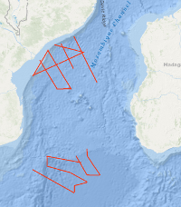
From 15th September to 26th October 2007 BGR together with the German Alfred-Wegener Institute for Polar and Marine Research (AWI), Bremerhaven, the French Institutes from Brest Institut Français de Recherche pour l'Exploitation de la Mer (IFREMER) and Institut Polaire Français Paul-Emile Victor (the French Polar Institute, IPEV) and the Portuguese Institute Laboratório de Tectonofísica e Tectónica Experimental (LATTEX) conducted a marine geophysical research cruise on the French research vessel R/V MARION DUFRESNE. The cruise BGR07 MoBaMaSis consisted of two legs MD163 off Central Mozambique and MD164 off Southern Mozambique. The main research objective was to contribute to a better understanding of the initial breakup and the early opening of the Eastern Gondwana. Im Zeitraum vom 15. September bis zum 26. Oktober 2007 führte die BGR zusammen mit dem Alfred-Wegener-Institut für Polar- und Meeresforschung (AWI), dem Institut Français de Recherche pour l'Exploitation de la Mer (IFREMER) und dem Institut Polaire Français Paul-Emile Victor (IPEV) sowie dem portugiesischen Institut Laboratório de Tectonofísica e Tectónica Experimental (LATTEX) seismische Profilmessungen mit dem französischen Forschungsschiff R/V MARION DUFRESNE durch. Die Fahrt BGR07 MoBaMaSis bestand aus zwei Fahrtabschnitten MD163 zwischen 21°S/41°E und 17°S/35°E vor Zentral-Mosambik und MD154 zwischen 25°S/36°E und 28°30’S/41°E vor dem südlichen Teil Mosambiks. Ziel der Untersuchungen war ein besseres Verständnis der Zerfallsgeschichte des Großkontinents Gondwana.
Raumbezug
Lage der Geodaten (in WGS84)
| SW Länge/Breite | NO Länge/Breite | |
|---|---|---|
| 36.216°/-28.424° | 41.055°/-17.228° |
| Koordinatensystem |
|---|
Verweise und Downloads
Weitere Verweise (21)
| Identifikator des übergeordneten Metadatensatzes |
06a73c56-06a2-40d8-b806-466222b0760d |
|---|
Nutzung
| Nutzungsbedingungen |
Allgemeine Geschäftsbedingungen, siehe http://www.bgr.bund.de/AGB - General terms and conditions, see http://www.bgr.bund.de/AGB_en. Die bereitgestellten Informationen sind bei Weiterverwendung wie folgt zu zitieren: Datenquelle: BGR 2007 MoBaMaSis, (c) BGR, Hannover, 2007 |
|---|
| Zugriffsbeschränkungen |
no limitations to public access |
|---|
Kontakt
Fachinformationen
Informationen zum Datensatz
| Identifikator |
93184377-283f-d9cc-56df-6b8aa1055109 |
|---|
| Digitale Repräsentation |
Vector |
|---|
| Fachliche Grundlage |
During the period from 15st September to 26th of October 2007 BGR acquired seismic lines in the Mozambique Channel. The lines BGR07-201, BGR07-202, BGR07-203, BGR07-204, BGR07-206, BGR07-207, BGR07-208, BGR07-209, BGR07-209A, BGR07-210, BGR07-211, BGR07-212, BGR07-213, BGR07-214, BGR07-214A, BGR07-214B, BGR07-214C are processed (migrated) data, whereas line BGR07-205 consists of raw data and line BGR07-205A consists of stacked data. |
|---|
Zusatzinformationen
| Sprache des Datensatzes |
Englisch |
|---|
Konformität
| Spezifikation der Konformität | Spezifikationsdatum | Grad der Konformität | Geprüft mit |
|---|---|---|---|
| VERORDNUNG (EG) Nr. 1089/2010 DER KOMMISSION vom 23. November 2010 zur Durchführung der Richtlinie 2007/2/EG des Europäischen Parlaments und des Rates hinsichtlich der Interoperabilität von Geodatensätzen und -diensten | 08.12.2010 | siehe dazu die angegebene Durchführungsbestimmung |
Datenformat
| Name | Version | Kompressionstechnik | Spezifikation |
|---|---|---|---|
| Shapefile | n/a |
Schlagworte
| INSPIRE-Themen | Geology |
| GEMET-Concepts | geophysics Geophysik raw material Rohstoff |
| ISO-Themenkategorien | Geoscientific Information |
| Suchbegriffe | Indian Ocean Indischer Ozean Marine geology Meeresgeologie Mosambik-Kanal Mozambique Channel Seismics Seismik Two-dimensional seismic reflection zweidimensionale Reflektionsseismik |
Informationen zum Metadatensatz
| Objekt-ID |
47ba0fb5-b585-45c4-9f4c-66d1387865eb |
|---|
| Aktualität der Metadaten |
16.11.2023 |
|---|
| Sprache Metadatensatz |
Englisch |
|---|
| Datensatz / Datenserie |
Dataset |
|---|
| XML Darstellung |
|---|
| Point of Contact (Metadatum) |
|---|
| Metadatenquelle |
GeoDaK (Datenkatalog der Bundesanstalt für Geowissenschaften und Rohstoffe)
|
|---|---|
|
Bundesanstalt für Geowissenschaften und Rohstoffe
|


