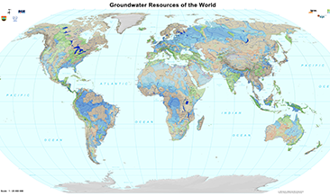
The World-wide Hydrogeological Mapping and Assessment Programme (WHYMAP) provides data and information about the earth´s major groundwater resources. The Groundwater Resources Map shows various characteristic groundwater environments in their areal extent and classified by their aquifer productivity and recharge potential. Additional groundwater related features such as wetlands and areas of low rainfall are included in the dataset. Das World-wide Hydrogeological Mapping and Assessment Programme (WHYMAP) stellt Daten und Informationen über die weltweiten Grundwasservorkommen bereit. Die Karte der Grundwasservorkommen der Welt zeigt typische Grundwasserkörper in ihrer geografischen Ausdehnung, deren Ergiebigkeit sowie potentielle Grundwasserneubildungraten. Der Datensatz wird mit zusätzlichen Informationen (z.B. Sumpflandschaften und Gebiete mit geringem Niederschlag) ergänzt.
Raumbezug
Lage der Geodaten (in WGS84)
| SW Länge/Breite | NO Länge/Breite | |
|---|---|---|
| -180.0°/-90.0° | 180.0°/90.0° |
| Koordinatensystem |
|---|
Verweise und Downloads
Querverweise (1)
WMS
Geodatendienst
Groundwater Resources of the World (WHYMAP GWR) (WMS)
The World-wide Hydrogeological Mapping and Assessment Programme (WHYMAP) provides data and information about the earth´s major groundwater resources. The Groundwater Resources Map shows various characteristic groundwater environments in their areal extent and classified by their aquifer productivity and recharge potential. Additional groundwater related features such as wetlands and areas of low rainfall are included in the dataset.
Kartenansicht öffnen
Weitere Verweise (2)
https://services.bgr.de/grundwasser/whymap_gwr
Information
Karte im BGR-Geoviewer
Website
Information
Nutzung
| Nutzungsbedingungen |
Allgemeine Geschäftsbedingungen, s.: https://www.bgr.bund.de/AGB - General terms and conditions, s. https://www.bgr.bund.de/AGB_en; Die bereitgestellten Informationen sind bei Weiterverwendung wie folgt zu zitieren: Datenquelle: WHYMAP, (C) BGR Hannover & UNESCO Paris |
|---|
| Zugriffsbeschränkungen |
no limitations to public access |
|---|
Kontakt
Fachinformationen
Informationen zum Datensatz
| Identifikator |
010a4885-4f3b-4285-99de-14ab983c18ee |
|---|
| Digitale Repräsentation |
Vector |
|---|
Erstellungsmaßstab
| Maßstab 1:x |
25000000 |
|---|
| Fachliche Grundlage |
World-wide Hydrogeological Mapping and Assessment Programme (WHYMAP) |
|---|
Zusatzinformationen
| Sprache des Datensatzes |
Englisch |
|---|
Datenformat
| Name | Version | Kompressionstechnik | Spezifikation |
|---|---|---|---|
| Shapefile | n/a |
Schlagworte
| INSPIRE-Themen | Geology |
| GEMET-Concepts | Groundwater Grundwasser Hydrogeologie Hydrogeology |
| ISO-Themenkategorien | Geoscientific Information |
| Suchbegriffe | Aquifer Groundwater abstraction Groundwater recharge Groundwater resources Grundwasserentnahme Grundwasserneubildung Grundwasservorkommen Weltweit World-wide |
Informationen zum Metadatensatz
| Objekt-ID |
29949f35-6fe1-4775-bc97-62274a30c70b |
|---|
| Aktualität der Metadaten |
12.03.2025 |
|---|
| Sprache Metadatensatz |
Englisch |
|---|
| Datensatz / Datenserie |
Dataset |
|---|
| XML Darstellung |
|---|
| Point of Contact (Metadatum) |
|---|
| Metadatenquelle |
GeoDaK (Datenkatalog der Bundesanstalt für Geowissenschaften und Rohstoffe)
|
|---|---|
|
Bundesanstalt für Geowissenschaften und Rohstoffe
|


