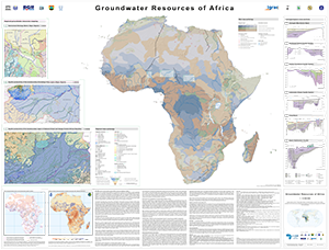
The Groundwater Resources of Africa Map represents the current state of WHYMAP’s groundwater resources mapping in Africa and was prepared for the 7th Africa Water Week 2018 in Libreville (Gabon). It includes novel features, such as cross-sections and regional transboundary hydrogeological maps, bringing together generalised overview maps and regional hydrogeological studies, thereby adding value through the inclusion of higher resolution spatial information in regions where ongoing BGR technical cooperation projects are taking place. These regional mapping activities methodologically follow the spirit of the development of the International Hydrogeological Map of Europe (IHME1500), the only harmonised, pan-European dataset at a scale of 1:1?500?000. For the IHME1500, a lithological classification scheme was developed at BGR (Duscher et al., 2015) and combined with the Standard Legend for Hydrogeological Maps (SLHyM) of Struckmeier & Margat (1995). The regional maps apply this European approach to the mapping of groundwater resources in Africa. These medium-scale maps are a further step towards regional integrated water resources planning and allow for specific analyses, such as vulnerability assessments of groundwater resources to climate change and pollution. The World-wide Hydrogeological Mapping and Assessment Programme (WHYMAP) is a joint programme consisting of a consortium composed by the UNESCO, the Commission for the Geological Map of the World (CGMW), the International Association of Hydrogeologists (IAH), the International Atomic Energy Agency (IAEA), the International Groundwater Resources Assessment Centre (IGRAC), and the German Federal Institute for Geosciences and Natural Resources (BGR). Its main objective is to contribute to the global effort to better understand, manage and protect aquifer resources, and to communicate this groundwater-related information appropriately to groundwater experts, non-experts and policy-makers. Die Karte der Grundwasserressourcen von Afrika zeigt den aktuellen Stand der WHYMAP-Kartierung der Grundwasservorkommen in Afrika, die für die 7. Afrika-Wasserwoche 2018 in Libreville (Gabun) erstellt wurde. Sie enthält neue Merkmale wie Profilschnitte und regionale, grenzüberschreitende hydrogeologische Karten, die allgemeine Übersichtskarten und regionale hydrogeologische Studien zusammenführen und dadurch einen zusätzlichen Wert schaffen, indem sie räumliche Informationen mit höherer Auflösung in Regionen enthalten, in denen laufende Projekte der technischen Zusammenarbeit der BGR stattfinden. Diese regionalen Kartierungsaktivitäten orientieren sich methodisch an der Entwicklung der Internationalen Hydrogeologischen Karte von Europa (IHME1500), dem einzigen europaweit harmonisierten Datensatz im Maßstab 1:1 500 000. Für die IHME1500 wurde an der BGR ein lithologisches Klassifikationsschema entwickelt (Duscher et al., 2015) und mit der Standardlegende für hydrogeologische Karten (SLHyM) von Struckmeier & Margat (1995) versehen. Die regionalen Karten übertragen diesen europäischen Ansatz auf die Kartierung von Grundwasserressourcen in Afrika. Diese mittelmaßstäbigen Karten stellen einen weiteren Schritt in der regionalen Wasserressourcenplanung dar und ermöglichen spezifische Analysen, z. B. die Bewertung der Empfindlichkeit von Grundwasserressourcen gegenüber Klimawandel und Umweltverschmutzung. Das World-wide Hydrogeological Mapping and Assessment Programme (WHYMAP) ist ein Gemeinschaftsprogramm der UNESCO, der Commission for the Geological Map of the World (CGMW), der International Association of Hydrogeologists (IAH), der International Atomic Energy Agency (IAEA), des International Groundwater Resources Assessment Centre (IGRAC) und der Bundesanstalt für Geowissenschaften und Rohstoffe (BGR). Ihr Hauptziel ist es, einen Beitrag zu den weltweiten Bemühungen zu leisten, die Grundwasserressourcen besser zu verstehen, zu bewirtschaften und zu schützen und diese Grundwasserinformationen in geeigneter Weise an Grundwasserexperten sowie an Laien und politische Entscheidungsträger weiterzugeben.


