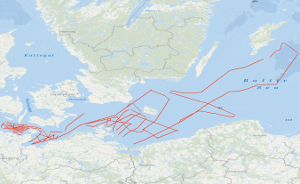
The major pre-alpine tectonic lineaments as the Glückstadt Graben and the Avalonia-Baltica suture zone run across the southern Baltic. The BalTec expedition aimed at the gapless imaging of these fault systems from the seafloor down to the Paleozoic basement. Scientifically the expedition was motivated by two hypotheses. We postulated that advances and retreats of icesheets during the glacials initiated and reactivated faulting of the Post-Permian succession, thereby generating several kilometers long near-vertical faults and anticlines. We further postulated that – in contrast to the generally accepted text book models – deformation of the initially up to 1800 m thick Zechstein salt started already during salt deposition as the consequence of salt load induced basin subsidence and resulting salt creep. The profile network was further designed to allow for linking the stratigraphy between previously generated local underground models in the frame of the TUNB project. Altogether we collected during cruise MSM52 onboard of R/V Maria S. Merian 62 reflection seismic profiles of an entire length of 3500 km. This data set contains all seismic lines located in the German EEZ (lines BGR16-212 to BGR16-264) as time-migrated version. Im Untergrund der südlichen Ostsee verlaufen die dominierenden prä-alpinen Störungssysteme Nordeuropas, z.B. der Glückstadtgraben und die Avalonia-Baltica Suturzone. Arbeitsziele des BalTec-Projektes waren, diese Störungssysteme lückenlos vom Meeresboden bis zum paläozoischen Grundgebirge mit bisher unerreichter Auflösung reflexions- und refraktionsseismisch abzubilden. Überprüft werden sollte die These, dass das Vor- und Zurückschreiten der Eisgletscher während der Eiszeiten in den post-permischen Abfolgen Bruchtektonik initiierte und zuvor angelegte Störungen reaktivierte. Diese glazial induzierte Tektonik erzeugte über viele Kilometer lange, steil-stehende Störungen und Antiklinen. Weiterhin galt es die Frage zu untersuchen, ob entgegen der Lehrbuch-Modelle die Deformation der initial bis zu 1800 m mächtigen Zechsteinabfolgen bereits während der Salzablagerung erfolgte. Die These lautet, dass die größer werdende Salzauflast zu Subsidenz und Verkippung des Beckens führte, was wiederum Salzfluss zum Subsidenzzentrum veranlasste. Die Profile wurden außerdem so geplant, dass mit ihnen im Rahmen des TUNB-Projektes die stratigraphische Verbindung zwischen bestehenden, lokalen Untergrundsmodellen hergestellt werden kann. Insgesamt vermaßen wir während der Fahrt MSM52 mit FS Maria S. Merian 62 reflexionsseismische Profile mit einer Gesamtlänge von etwa 3500 km. Der vorliegende Datensatz enthält die in der deutschen AWZ befindlichen Profillinien (BGR16-212 bis BGR16-264) als zeitmigrierte Version.
Raumbezug
Lage der Geodaten (in WGS84)
| SW Länge/Breite | NO Länge/Breite | |
|---|---|---|
| 10.13°/54.054° | 19.664°/57.305° |
| Koordinatensystem |
|---|
Verweise und Downloads
Downloads (2)
Daten (SEG-Y)
Daten im Format SEG-Y
[3000.0 MB]
Fahrtlinien (Shapefile)
Fahrtlinien im Format ESRI Shape
[2.0 MB]
Weitere Verweise (52)
Fahrtbericht
Information
Fahrtbericht
http://www.geo-seas.eu/v_cdi_v3/print_ajax.asp?n_code=2633164
Information
Profile BGR16-212
http://www.geo-seas.eu/v_cdi_v3/print_ajax.asp?n_code=2633165
Information
Profile BGR16-213
http://www.geo-seas.eu/v_cdi_v3/print_ajax.asp?n_code=2633166
Information
Profile BGR16-214
http://www.geo-seas.eu/v_cdi_v3/print_ajax.asp?n_code=2633167
Information
Profile BGR16-215a
http://www.geo-seas.eu/v_cdi_v3/print_ajax.asp?n_code=2633168
Information
Profile BGR16-216
http://www.geo-seas.eu/v_cdi_v3/print_ajax.asp?n_code=2633169
Information
Profile BGR16-217
http://www.geo-seas.eu/v_cdi_v3/print_ajax.asp?n_code=2633170
Information
Profile BGR16-218
http://www.geo-seas.eu/v_cdi_v3/print_ajax.asp?n_code=2633171
Information
Profile BGR16-219
http://www.geo-seas.eu/v_cdi_v3/print_ajax.asp?n_code=2633172
Information
Profile BGR16-220
http://www.geo-seas.eu/v_cdi_v3/print_ajax.asp?n_code=2633173
Information
Profile BGR16-221
http://www.geo-seas.eu/v_cdi_v3/print_ajax.asp?n_code=2633174
Information
Profile BGR16-222
http://www.geo-seas.eu/v_cdi_v3/print_ajax.asp?n_code=2633175
Information
Profile BGR16-224
http://www.geo-seas.eu/v_cdi_v3/print_ajax.asp?n_code=2633176
Information
Profile BGR16-225
http://www.geo-seas.eu/v_cdi_v3/print_ajax.asp?n_code=2633177
Information
Profile BGR16-226
http://www.geo-seas.eu/v_cdi_v3/print_ajax.asp?n_code=2633178
Information
Profile BGR16-227
http://www.geo-seas.eu/v_cdi_v3/print_ajax.asp?n_code=2633179
Information
Profile BGR16-228
http://www.geo-seas.eu/v_cdi_v3/print_ajax.asp?n_code=2633180
Information
Profile BGR16-229
http://www.geo-seas.eu/v_cdi_v3/print_ajax.asp?n_code=2633181
Information
Profile BGR16-229a
http://www.geo-seas.eu/v_cdi_v3/print_ajax.asp?n_code=2633182
Information
Profile BGR16-230
http://www.geo-seas.eu/v_cdi_v3/print_ajax.asp?n_code=2633183
Information
Profile BGR16-231
http://www.geo-seas.eu/v_cdi_v3/print_ajax.asp?n_code=2633184
Information
Profile BGR16-232
http://www.geo-seas.eu/v_cdi_v3/print_ajax.asp?n_code=2633185
Information
Profile BGR16-234
http://www.geo-seas.eu/v_cdi_v3/print_ajax.asp?n_code=2633186
Information
Profile BGR16-235
http://www.geo-seas.eu/v_cdi_v3/print_ajax.asp?n_code=2633187
Information
Profile BGR16-237
http://www.geo-seas.eu/v_cdi_v3/print_ajax.asp?n_code=2633188
Information
Profile BGR16-238
http://www.geo-seas.eu/v_cdi_v3/print_ajax.asp?n_code=2633189
Information
Profile BGR16-239
http://www.geo-seas.eu/v_cdi_v3/print_ajax.asp?n_code=2633190
Information
Profile BGR16-240
http://www.geo-seas.eu/v_cdi_v3/print_ajax.asp?n_code=2633191
Information
Profile BGR16-241
http://www.geo-seas.eu/v_cdi_v3/print_ajax.asp?n_code=2633192
Information
Profile BGR16-242
http://www.geo-seas.eu/v_cdi_v3/print_ajax.asp?n_code=2633193
Information
Profile BGR16-243
http://www.geo-seas.eu/v_cdi_v3/print_ajax.asp?n_code=2633194
Information
Profile BGR16-244
http://www.geo-seas.eu/v_cdi_v3/print_ajax.asp?n_code=2633195
Information
Profile BGR16-246
http://www.geo-seas.eu/v_cdi_v3/print_ajax.asp?n_code=2633196
Information
Profile BGR16-247
http://www.geo-seas.eu/v_cdi_v3/print_ajax.asp?n_code=2633197
Information
Profile BGR16-248
http://www.geo-seas.eu/v_cdi_v3/print_ajax.asp?n_code=2633198
Information
Profile BGR16-249
http://www.geo-seas.eu/v_cdi_v3/print_ajax.asp?n_code=2633199
Information
Profile BGR16-250
http://www.geo-seas.eu/v_cdi_v3/print_ajax.asp?n_code=2633200
Information
Profile BGR16-251
http://www.geo-seas.eu/v_cdi_v3/print_ajax.asp?n_code=2633201
Information
Profile BGR16-252
http://www.geo-seas.eu/v_cdi_v3/print_ajax.asp?n_code=2633202
Information
Profile BGR16-253
http://www.geo-seas.eu/v_cdi_v3/print_ajax.asp?n_code=2633203
Information
Profile BGR16-254
http://www.geo-seas.eu/v_cdi_v3/print_ajax.asp?n_code=2633204
Information
Profile BGR16-255
http://www.geo-seas.eu/v_cdi_v3/print_ajax.asp?n_code=2633205
Information
Profile BGR16-256
http://www.geo-seas.eu/v_cdi_v3/print_ajax.asp?n_code=2633206
Information
Profile BGR16-257
http://www.geo-seas.eu/v_cdi_v3/print_ajax.asp?n_code=2633207
Information
Profile BGR16-258
http://www.geo-seas.eu/v_cdi_v3/print_ajax.asp?n_code=2633208
Information
Profile BGR16-259
http://www.geo-seas.eu/v_cdi_v3/print_ajax.asp?n_code=2633209
Information
Profile BGR16-260
http://www.geo-seas.eu/v_cdi_v3/print_ajax.asp?n_code=2633210
Information
Profile BGR16-261
http://www.geo-seas.eu/v_cdi_v3/print_ajax.asp?n_code=2633211
Information
Profile BGR16-262
http://www.geo-seas.eu/v_cdi_v3/print_ajax.asp?n_code=2633212
Information
Profile BGR16-263
http://www.geo-seas.eu/v_cdi_v3/print_ajax.asp?n_code=2633213
Information
Profile BGR16-264
https://services.bgr.de/geophysik/mssp
Information
Karte im BGR-Geoviewer
| Identifikator des übergeordneten Metadatensatzes |
06a73c56-06a2-40d8-b806-466222b0760d |
|---|
Nutzung
| Nutzungsbedingungen |
Allgemeine Geschäftsbedingungen, siehe http://www.bgr.bund.de/AGB - General terms and conditions, see http://www.bgr.bund.de/AGB_en. Die bereitgestellten Informationen sind bei Weiterverwendung wie folgt zu zitieren: Datenquelle: BGR16-2 2016, (c) BGR, Hannover, 2018 |
|---|
| Zugriffsbeschränkungen |
no limitations to public access |
|---|
Kontakt
Fachinformationen
Informationen zum Datensatz
| Identifikator |
5f66564a-10c9-205f-4e46-661397847638 |
|---|
| Digitale Repräsentation |
Vector |
|---|
| Fachliche Grundlage |
During the period from the 1st March to the 28th March 2016 BGR acquired seismic lines in the Baltic Sea. The lines BGR16-200d, BGR16-201 to BGR16-211 and BGR16-233 consist of raw data. The lines BGR16-212 to BGR16-264 (with exception of profile BGR16-233 with raw data) are migrated data. |
|---|
Zusatzinformationen
| Sprache des Datensatzes |
Englisch |
|---|
Konformität
| Spezifikation der Konformität | Spezifikationsdatum | Grad der Konformität | Geprüft mit |
|---|---|---|---|
| VERORDNUNG (EG) Nr. 1089/2010 DER KOMMISSION vom 23. November 2010 zur Durchführung der Richtlinie 2007/2/EG des Europäischen Parlaments und des Rates hinsichtlich der Interoperabilität von Geodatensätzen und -diensten | 08.12.2010 | siehe dazu die angegebene Durchführungsbestimmung |
Datenformat
| Name | Version | Kompressionstechnik | Spezifikation |
|---|---|---|---|
| Shapefile | n/a | ||
| SEG-Y | n/a |
Informationen zum Metadatensatz
| Objekt-ID |
128e35d3-9caa-4039-988e-2a83c53efa0d |
|---|
| Aktualität der Metadaten |
04.03.2024 |
|---|
| Sprache Metadatensatz |
Englisch |
|---|
| Datensatz / Datenserie |
Dataset |
|---|
| XML Darstellung |
|---|
| Point of Contact (Metadatum) |
|---|
| Metadatenquelle |
GeoDaK (Datenkatalog der Bundesanstalt für Geowissenschaften und Rohstoffe)
|
|---|---|
|
Bundesanstalt für Geowissenschaften und Rohstoffe
|


