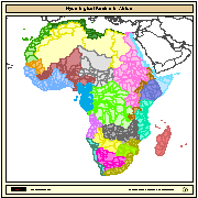
Major hydrological basins and their sub-basins. This dataset divides the African continent according to its hydrological characteristics. The dataset consists of the following information:- numerical code and name of the major basin (MAJ_BAS and MAJ_NAME); - area of the major basin in square km (MAJ_AREA); - numerical code and name of the sub-basin (SUB_BAS and SUB_NAME); - area of the sub-basin in square km (SUB_AREA); - numerical code of the sub-basin towards which the sub-basin flows (TO_SUBBAS) (the codes -888 and -999 have been assigned respectively to internal sub-basins and to sub-basins draining into the sea)
Raumbezug
Lage der Geodaten (in WGS84)
| SW Länge/Breite | NO Länge/Breite | |
|---|---|---|
| -17.3°/-34.6° | 51.1°/38.2° |
| Koordinatensystem |
WGS 1984
|
|---|
Verweise und Downloads
Weitere Verweise (3)
Fachinformationen
Informationen zum Datensatz
| Digitale Repräsentation |
Vektor |
|---|
Erstellungsmaßstab
| Maßstab 1:x |
5000000 |
|---|
| Fachliche Grundlage |
The linework of the map is obtained by delineating drainage basin boundaries from an hydrologically corrected digital elevation model with a resolution of 1 * 1 km. |
|---|
Zusatzinformationen
| Herstellungszweck |
This dataset is developed as part of a GIS-based information system on water resources for the African continent. It has been published in the framework of the AQUASTAT - programme of the Land and Water Division of the Food and Agriculture Organization of the United Nations, as part of FAO Land and Water Digital Media Series #13: "Atlas of Water Resources and Irrigation in Africa". For a wider distribution and to support other projects at FAO this map is also distributed in a DVD as part of a publication entitled: "Jenness, J.; Dooley, J.; Aguilar-Manjarrez, J.; Riva, C. African Water Resource Database. GIS-based tools for inland aquatic resource management. 2. Technical manual and workbook. CIFA Technical Paper. No. 33, Part 2. Rome, FAO. 2007. 308 p." |
|---|
Datenformat
| Name | Version | Kompressionstechnik | Spezifikation |
|---|---|---|---|
| ShapeFile | Grass Version 6.1 |
Informationen zum Metadatensatz
| Objekt-ID |
da165110-88fd-11da-a88f-000d939bc5d8 |
|---|
| Aktualität der Metadaten |
06.11.2007 12:13:00 |
|---|
| XML Darstellung |
|---|
| Ansprechpartner (Metadatum) |
|---|
| Metadatenquelle |
GDI-NI-Katalog (Geodateninfrastruktur Niedersachsen)
|
|---|---|
|
Geodatenportal Niedersachsen
|
|
|
Landesamt für Geoinformation und Landesvermessung Niedersachsen
|


