Suche Karten Messwerte Kataloge Über NUMIS Anbieter Datenquellen API
Hilfe Kontakt Inhalt Impressum Datenschutz Barrierefreiheit
NUMIS - Das niedersächsische Umweltportal NUMIS - Das niedersächsische Umweltportal
Suche
Karten
Messwerte
Kataloge
API
Alle Suchergebnisse
Geodatensatz

Processed seismic data of Cruise SO85 VOKSA 1993

Inhalt
  • Übersicht
  • Be­schrei­bung
    Aktualität des Datensatzes
  • Raumbezug
  • Verweise und Downloads
    Downloads Weitere Verweise
  • Nutzung
  • Kontakt
    Point of Contact
  • Fach­informationen
    Informationen zum Datensatz Zusatzinformationen Schlag­worte
  • Metadatensatz

Downloads (1)

SO85 VOKSA 1993 (Shapefile) SO85 VOKSA 1993 im Format ESRI Shape [2.0 MB]

Nutzungs­bedingun­gen

Allgemeine Geschäftsbedingungen, siehe http://www.bgr.bund.de/AGB - General terms and conditions, see http://www.bgr.bund.de/AGB_en. Die bereitgestellten Informationen sind bei Weiterverwendung wie folgt zu zitieren: Datenquelle: SO85 VOKSA 1993, (c) BGR, Hannover, 2018

Point of Contact

Federal Institute for Geosciences and Natural Resources

Marine_Seismik@bgr.de

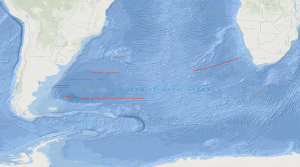
Vorschau

img

Be­schrei­bung

SO85 VOKSA 1993

SONNE cruise SO-85 was designed to study the variability of the oceanic crustal structure along flow-line profiles over Early Tertiary through Early Cretaceous old crust in the Cape and Argentine basins of the South Atlantic. Between 21th February and 20th April 1993 deep imaging seismic reflection data in parallel with magnetic, gravimetric and hydroacoustic measurements have been collected along a 1,405 km long flow-line traverse across the Cape basin, and along three flow-line traverses across the Argentine basin with a total length of 4,255 km. A special geophysical survey was carried out on the Argentine continental margin. Although bad weather hampered the geophysical measurements in the Argentine basin, some new and intriguing observations were made: (1) the presence of an elongated wedge of seaward dipping reflectors, often associated with the distinct magnetic anomaly 'G', was confirmed on both, the South African and Argentine continental margins; (2) the sequence of seaward-dipping reflectors consists of two wedges. The younger wedge rests partly on the older one; (3) the surface of the oceanic crust lies more deep in the Argentine basin than in the Cape basin; (4) the structure of the oceanic crust is more variable in time and space within the Argentine and Cape basins than within the Angola and Brazil basins; (5) despite this, it appears that the oceanic crust generated during the younger half of the Cretaceous magnetic quiet period up to C 33r is characterized by relative high reflectivity in lower crustal levels; (6) high-amplitude magnetic anomalies C 33 through C 34 are apparently correlatable with oceanic crustal segments characterized by common seismic features, e.g. a smooth and scarped surface of the oceanic crust; (7) an elongated, positive gravity anomaly exists at about 58°E between 43.5°E and 47°E. Während der Sonne-Fahrt SO-85 vom 21. Februar bis zum 20. April 1993 sind tiefenreflexionsseismische Daten und gravimetrische, magnetische und hydroakustische Messwerte auf 'flow-line' Traversen über ozeanische Kruste gesammelt worden, die von der frühen Kreidezeit bis zur frühen Tertiärzeit am mittelozeanischen Rücken des Südatlantik gebildet worden ist. Die geophysikalischen Daten von insgesamt 6.607 km Profillänge zeigen größere Variabilität der ozeanischen Kruste in Zeit und Raum innerhalb des Argentinischen Beckens und des Kap-Beckens im Vergleich zum Angola-Becken resp. dem Brasilianischen Becken. Die Existenz eines ausgedehnten Gürtels mit seewärts einfallendem Schichtungsmuster ist am südafrikanischen und argentinischen Kontinentalrand bestätigt worden. Obwohl die Oberfläche der ozeanischen Kruste im Argentinischen Becken tiefer liegt, gibt es gute Hinweise dafür, dass die während der jüngeren Hälfte der kretazisch magnetisch ruhigen Periode generierte ozeanische Kruste bis hin zur magnetischen Anomalie C 33r durch relativ hohe Reflektivität in der ozeanischen Unterkruste ausgezeichnet ist. In diesem Segment haben die magnetischen Anomalien C 33 bis C 34 auch meist hohe Amplituden.

Aktualität des Datensatzes

Creation

20.04.1993

Status

completed

Raumbezug

Lage der Geodaten (in WGS84)
SW Länge/Breite NO Länge/Breite
-59.001°/-47.833° 13.74°/-31.761°
Koordinaten­system
EPSG:4326

Verweise und Downloads

Downloads (1)

SO85 VOKSA 1993 (Shapefile) SO85 VOKSA 1993 im Format ESRI Shape [2.0 MB]

Weitere Verweise (1)

https://services.bgr.de/geophysik/mssp Information Karte im BGR-Geoviewer
Identifikator des über­geordneten Metadaten­satzes

06a73c56-06a2-40d8-b806-466222b0760d

Nutzung

Nutzungs­bedingun­gen

Allgemeine Geschäftsbedingungen, siehe http://www.bgr.bund.de/AGB - General terms and conditions, see http://www.bgr.bund.de/AGB_en. Die bereitgestellten Informationen sind bei Weiterverwendung wie folgt zu zitieren: Datenquelle: SO85 VOKSA 1993, (c) BGR, Hannover, 2018

Zugriffs­beschränkun­gen

no limitations to public access

Kontakt

Point of Contact

Federal Institute for Geosciences and Natural Resources

Stilleweg 2
30655 Hannover

Marine_Seismik@bgr.de

Fach­informationen

Informationen zum Datensatz

Identifikator

ecce46ec-40c9-f743-972d-56602e6c8cfc

Digitale Repräsentation

Vector

Fachliche Grundlage

During the period from 21th February 1993 to 20th April 1993 BGR acquired seismic lines off the Atlantic coast of South America. The lines SO85-01A, SO85-01B, SO85-01C, SO85-01D, SO85-02A, SO85-02B, SO85-03A, SO85-03B, SO85-03C, SO85-03E, SO85-04A, SO85-04B, SO85-04C, SO85-04D and SO85-04E consist of raw data. Lines SO85-05 and SO85-06 are stacked data. Line SO85-05A consists of migrated data.

Zusatzinformationen

Sprache des Daten­satzes

Englisch

Kon­formi­tät
Spezifi­kation der Kon­formi­tät Spezifi­kations­datum Grad der Kon­formi­tät Geprüft mit
VERORDNUNG (EG) Nr. 1089/2010 DER KOMMISSION vom 23. November 2010 zur Durchführung der Richtlinie 2007/2/EG des Europäischen Parlaments und des Rates hinsichtlich der Interoperabilität von Geodatensätzen und -diensten 08.12.2010 siehe dazu die angegebene Durchführungsbestimmung
Datenformat
Name Version Kompressionstechnik Spezifi­kation
Shapefile n/a

Schlag­worte

INSPIRE-Themen Geology
GEMET-Concepts geophysics Geophysik raw material Rohstoff
ISO-Themen­kategorien Geoscientific Information
Suchbegriffe Argentine Basin Argentinisches Becken Cape Basin Kap-Becken Marine geology Meeresgeologie Seismics Seismik South Atlantik Südatlantik Two-dimensional seismic reflection zweidimensionale Reflektionsseismik

Informationen zum Metadatensatz

Objekt-ID

90c18a47-0d6d-48ef-a3d3-10d57f2f2a11

Aktualität der Metadaten

16.11.2023

Sprache Metadatensatz

Englisch

Datensatz / Datenserie  

Dataset

XML Dar­stellung
Metadaten als XML herunter­laden
Point of Contact (Metadatum)
geodatenmanagement@bgr.de
Metadatenquelle
GeoDaK (Datenkatalog der Bundesanstalt für Geowissenschaften und Rohstoffe)
Bundesanstalt für Geowissenschaften und Rohstoffe

NUMIS - Das niedersächsische Umweltportal
Niedersächsisches Ministerium für Umwelt,
Energie und Klimaschutz
Hilfe Kontakt Inhalt Impressum Datenschutz Barrierefreiheit
Nach oben

Hilfe

NUMIS NUMIS
UVP UVP