Suche Karten Messwerte Kataloge Über NUMIS Anbieter Datenquellen API
Hilfe Kontakt Inhalt Impressum Datenschutz Barrierefreiheit
NUMIS - Das niedersächsische Umweltportal NUMIS - Das niedersächsische Umweltportal
Suche
Karten
Messwerte
Kataloge
API
Alle Suchergebnisse
Geodatensatz

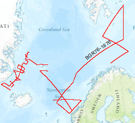
Processed seismic data of Cruise BGR 1976

Inhalt
  • Übersicht
  • Be­schrei­bung
    Aktualität des Datensatzes
  • Raumbezug
  • Verweise und Downloads
    Downloads Weitere Verweise
  • Nutzung
  • Kontakt
    Point of Contact
  • Fach­informationen
    Informationen zum Datensatz Zusatzinformationen Schlag­worte
  • Metadatensatz

Downloads (1)

BGR76 1976 (Shapefile) BGR76 1976 im Format ESRI Shape [1.0 MB]

Nutzungs­bedingun­gen

Allgemeine Geschäftsbedingungen, siehe https://www.bgr.bund.de/AGB - General terms and conditions, see https://www.bgr.bund.de/AGB_en. Die bereitgestellten Informationen sind bei Weiterverwendung wie folgt zu zitieren: Datenquelle: BGR76, (c) BGR, Hannover, 1976

Point of Contact

Federal Institute for Geosciences and Natural Resources

Marine_Seismik@bgr.de

Vorschau

img

Be­schrei­bung

BGR76 1976

On the MS Explora (1st September, 1976 - 29th September, 1976) multichannel seismic measurements were carried out on 44 lines The area covered was the Barentssea. The data format is Society of Exploration Geophysicists SEG Y. Im Gebiet der Barentssee wurden vom 01.09.1976 bis 29.09.1976 mit MS Explora mehrkanalseismische Messungen durchgeführt. Die Daten der 44 Profile liegen im SEG-Y Format vor.

Aktualität des Datensatzes

Creation

10.09.1976

Status

completed

Raumbezug

Lage der Geodaten (in WGS84)
SW Länge/Breite NO Länge/Breite
-28.469°/62.234° 32.295°/78.618°
Koordinaten­system
EPSG:4326

Verweise und Downloads

Downloads (1)

BGR76 1976 (Shapefile) BGR76 1976 im Format ESRI Shape [1.0 MB]

Weitere Verweise (45)

http://www.geo-seas.eu/v_cdi_v3/print_ajax.asp?n_code=1299278 Information Profil BGR76-01
http://www.geo-seas.eu/v_cdi_v3/print_ajax.asp?n_code=1299279 Information Profil BGR76-02
http://www.geo-seas.eu/v_cdi_v3/print_ajax.asp?n_code=1299280 Information Profil BGR76-03
http://www.geo-seas.eu/v_cdi_v3/print_ajax.asp?n_code=1299281 Information Profil BGR76-04
http://www.geo-seas.eu/v_cdi_v3/print_ajax.asp?n_code=1299282 Information Profil BGR76-05
http://www.geo-seas.eu/v_cdi_v3/print_ajax.asp?n_code=1299283 Information Profil BGR76-07
http://www.geo-seas.eu/v_cdi_v3/print_ajax.asp?n_code=1299284 Information Profil BGR76-08
http://www.geo-seas.eu/v_cdi_v3/print_ajax.asp?n_code=1299285 Information Profil BGR76-09
http://www.geo-seas.eu/v_cdi_v3/print_ajax.asp?n_code=1299286 Information Profil BGR76-10
http://www.geo-seas.eu/v_cdi_v3/print_ajax.asp?n_code=1299287 Information Profil BGR76-11
http://www.geo-seas.eu/v_cdi_v3/print_ajax.asp?n_code=1299288 Information Profil BGR76-12
http://www.geo-seas.eu/v_cdi_v3/print_ajax.asp?n_code=1299289 Information Profil BGR76-13
http://www.geo-seas.eu/v_cdi_v3/print_ajax.asp?n_code=1299290 Information Profil BGR76-14
http://www.geo-seas.eu/v_cdi_v3/print_ajax.asp?n_code=1299291 Information Profil BGR76-15
http://www.geo-seas.eu/v_cdi_v3/print_ajax.asp?n_code=1299292 Information Profil BGR76-16
http://www.geo-seas.eu/v_cdi_v3/print_ajax.asp?n_code=1299293 Information Profil BGR76-17
http://www.geo-seas.eu/v_cdi_v3/print_ajax.asp?n_code=1299294 Information Profil BGR76-20
http://www.geo-seas.eu/v_cdi_v3/print_ajax.asp?n_code=1299295 Information Profil BGR76-21
http://www.geo-seas.eu/v_cdi_v3/print_ajax.asp?n_code=1299296 Information Profil BGR76-22
http://www.geo-seas.eu/v_cdi_v3/print_ajax.asp?n_code=1299297 Information Profil BGR76-23
http://www.geo-seas.eu/v_cdi_v3/print_ajax.asp?n_code=1299298 Information Profil BGR76-24
http://www.geo-seas.eu/v_cdi_v3/print_ajax.asp?n_code=1299299 Information Profil BGR76-25
http://www.geo-seas.eu/v_cdi_v3/print_ajax.asp?n_code=1299300 Information Profil BGR76-26
http://www.geo-seas.eu/v_cdi_v3/print_ajax.asp?n_code=1299301 Information Profil BGR76-27
http://www.geo-seas.eu/v_cdi_v3/print_ajax.asp?n_code=1299302 Information Profil BGR76-28
http://www.geo-seas.eu/v_cdi_v3/print_ajax.asp?n_code=1299303 Information Profil BGR76-29
http://www.geo-seas.eu/v_cdi_v3/print_ajax.asp?n_code=1299304 Information Profil BGR76-30
http://www.geo-seas.eu/v_cdi_v3/print_ajax.asp?n_code=1299305 Information Profil BGR76-31
http://www.geo-seas.eu/v_cdi_v3/print_ajax.asp?n_code=1299306 Information Profil BGR76-32A
http://www.geo-seas.eu/v_cdi_v3/print_ajax.asp?n_code=1299307 Information Profil BGR76-34
http://www.geo-seas.eu/v_cdi_v3/print_ajax.asp?n_code=1299308 Information Profil BGR76-35
http://www.geo-seas.eu/v_cdi_v3/print_ajax.asp?n_code=1299309 Information Profil BGR76-38
http://www.geo-seas.eu/v_cdi_v3/print_ajax.asp?n_code=1299310 Information Profil BGR76-39
http://www.geo-seas.eu/v_cdi_v3/print_ajax.asp?n_code=1299311 Information Profil BGR76-40
http://www.geo-seas.eu/v_cdi_v3/print_ajax.asp?n_code=1299312 Information Profil BGR76-41
https://download.bgr.de/bgr/marineseismik/info/message_na.html Information Profil BGR76-06
https://download.bgr.de/bgr/marineseismik/info/message_na.html Information Profil BGR76-11A
https://download.bgr.de/bgr/marineseismik/info/message_na.html Information Profil BGR76-17A
https://download.bgr.de/bgr/marineseismik/info/message_na.html Information Profil BGR76-18
https://download.bgr.de/bgr/marineseismik/info/message_na.html Information Profil BGR76-19
https://download.bgr.de/bgr/marineseismik/info/message_na.html Information Profil BGR76-32
https://download.bgr.de/bgr/marineseismik/info/message_na.html Information Profil BGR76-33
https://download.bgr.de/bgr/marineseismik/info/message_na.html Information Profil BGR76-36
https://download.bgr.de/bgr/marineseismik/info/message_na.html Information Profil BGR76-37
https://services.bgr.de/geophysik/mssp Information Karte im BGR-Geoviewer
Identifikator des über­geordneten Metadaten­satzes

06a73c56-06a2-40d8-b806-466222b0760d

Nutzung

Nutzungs­bedingun­gen

Allgemeine Geschäftsbedingungen, siehe https://www.bgr.bund.de/AGB - General terms and conditions, see https://www.bgr.bund.de/AGB_en. Die bereitgestellten Informationen sind bei Weiterverwendung wie folgt zu zitieren: Datenquelle: BGR76, (c) BGR, Hannover, 1976

Zugriffs­beschränkun­gen

no limitations to public access

Kontakt

Point of Contact

Federal Institute for Geosciences and Natural Resources

Stilleweg 2
30655 Hannover

Marine_Seismik@bgr.de

Fach­informationen

Informationen zum Datensatz

Identifikator

bd6db4c9-8fca-45ca-9506-98f178eaef96

Digitale Repräsentation

Vector

Fachliche Grundlage

During the period from 1st of September to 29th of September 1976 BGR aquired seismic lines in the Barents Sea. The lines BGR76-01, BGR76-02, BGR76-03, BGR76-04, BGR76-05, BGR76-07, BGR76-08, BGR76-09, BGR76-10, BGR76-11, BGR76-11A, BGR76-12, BGR76-13, BGR76-14, BGR76-15, BGR76-16, BGR76-17, BGR76-20, BGR76-21, BGR76-22, BGR76-23, BGR76-24, BGR76-25, BGR76-26, BGR76-27, BGR76-28, BGR76-29, BGR76-30, BGR76-31, BGR76-34, BGR76-35, BGR76-38, BGR76-39, BGR76-40, BGR76-41 are processed (stack) data. The lines BGR76-06, BGR76-17A, BGR76-18, BGR76-19, BGR76-32, BGR76-32A, BGR76-33, BGR76-36 BGR76-37 are raw data.

Zusatzinformationen

Sprache des Daten­satzes

Englisch

Kon­formi­tät
Spezifi­kation der Kon­formi­tät Spezifi­kations­datum Grad der Kon­formi­tät Geprüft mit
VERORDNUNG (EG) Nr. 1089/2010 DER KOMMISSION vom 23. November 2010 zur Durchführung der Richtlinie 2007/2/EG des Europäischen Parlaments und des Rates hinsichtlich der Interoperabilität von Geodatensätzen und -diensten 08.12.2010 siehe dazu die angegebene Durchführungsbestimmung
Datenformat
Name Version Kompressionstechnik Spezifi­kation
Shapefile n/a

Schlag­worte

INSPIRE-Themen Geology
GEMET-Concepts geophysics Geophysik marine geology Meeresgeologie raw material Rohstoff
ISO-Themen­kategorien Geoscientific Information
Suchbegriffe Barents Sea Barentssee MSSP seismics Seismik two-dimensional seismic reflection zweidimensionale Reflektionsseismik

Informationen zum Metadatensatz

Objekt-ID

ef62c677-edef-4de3-b7d7-f8c7ffec1e1c

Aktualität der Metadaten

07.04.2025

Sprache Metadatensatz

Englisch

Datensatz / Datenserie  

Dataset

XML Dar­stellung
Metadaten als XML herunter­laden
Point of Contact (Metadatum)
geodatenmanagement@bgr.de
Metadatenquelle
GeoDaK (Datenkatalog der Bundesanstalt für Geowissenschaften und Rohstoffe)
Bundesanstalt für Geowissenschaften und Rohstoffe

NUMIS - Das niedersächsische Umweltportal
Niedersächsisches Ministerium für Umwelt,
Energie und Klimaschutz
Hilfe Kontakt Inhalt Impressum Datenschutz Barrierefreiheit
Nach oben

Hilfe

NUMIS NUMIS
UVP UVP