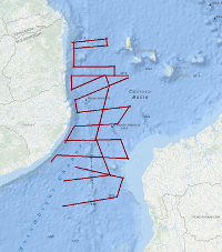
The main goals of the project SO231-PAGE4 were an improved understanding of Gondwana break-up and to analyze timing, structures and kinematics of ancient to modern Extension along the East African continental margin. During the cruise SO231 from 20th February 2014 (Durban) to 29th March 2014 (Durban), a total of 4300 km of geophysical profiles has been acquired. The processed (migrated) profiles are available in SEG-Y Format. Hauptziel des Projektes SO231-PAGE4 war es, einen Beitrag zum besseren Verständnis des Zerfalls von Gondwana zu liefern und Zeitlichkeit, Strukturen und Kinematik der bis in die Gegenwart anhaltenden Extension entlang des ostafrikanischen Kontinentrandes zu untersuchen. Die SONNE-Fahrt SO231 wurde vom 20. Februar 2014 (Durban) bis 29.03.2014 (Durban) durchgeführt. Auf 27 seismischen Profilen wurden ca. 4300 Profilkilometer vermessen. Die prozessierten (migrierten) Daten sind im SEG-Y Format erhältlich.
Raumbezug
Lage der Geodaten (in WGS84)
| SW Länge/Breite | NO Länge/Breite | |
|---|---|---|
| 39.964°/-18.738° | 43.444°/-11.367° |
| Koordinatensystem |
|---|
Verweise und Downloads
Weitere Verweise (30)
http://www.geo-seas.eu/v_cdi_v3/print_ajax.asp?n_code=2013151
Information
Profile BGR14-301
http://www.geo-seas.eu/v_cdi_v3/print_ajax.asp?n_code=2013152
Information
Profile BGR14-302
http://www.geo-seas.eu/v_cdi_v3/print_ajax.asp?n_code=2013153
Information
Profile BGR14-303
http://www.geo-seas.eu/v_cdi_v3/print_ajax.asp?n_code=2013154
Information
Profile BGR14-304
http://www.geo-seas.eu/v_cdi_v3/print_ajax.asp?n_code=2013155
Information
Profile BGR14-305
http://www.geo-seas.eu/v_cdi_v3/print_ajax.asp?n_code=2013156
Information
Profile BGR14-306
http://www.geo-seas.eu/v_cdi_v3/print_ajax.asp?n_code=2013157
Information
Profile BGR14-307
http://www.geo-seas.eu/v_cdi_v3/print_ajax.asp?n_code=2013158
Information
Profile BGR14-308
http://www.geo-seas.eu/v_cdi_v3/print_ajax.asp?n_code=2013159
Information
Profile BGR14-309
http://www.geo-seas.eu/v_cdi_v3/print_ajax.asp?n_code=2013160
Information
Profile BGR14-310
http://www.geo-seas.eu/v_cdi_v3/print_ajax.asp?n_code=2013161
Information
Profile BGR14-311
http://www.geo-seas.eu/v_cdi_v3/print_ajax.asp?n_code=2013162
Information
Profile BGR14-312
http://www.geo-seas.eu/v_cdi_v3/print_ajax.asp?n_code=2013163
Information
Profile BGR14-313
http://www.geo-seas.eu/v_cdi_v3/print_ajax.asp?n_code=2013164
Information
Profile BGR14-313A
http://www.geo-seas.eu/v_cdi_v3/print_ajax.asp?n_code=2013165
Information
Profile BGR14-314
http://www.geo-seas.eu/v_cdi_v3/print_ajax.asp?n_code=2013166
Information
Profile BGR14-315
http://www.geo-seas.eu/v_cdi_v3/print_ajax.asp?n_code=2013167
Information
Profile BGR14-316
http://www.geo-seas.eu/v_cdi_v3/print_ajax.asp?n_code=2013168
Information
Profile BGR14-317
http://www.geo-seas.eu/v_cdi_v3/print_ajax.asp?n_code=2013169
Information
Profile BGR14-317A
http://www.geo-seas.eu/v_cdi_v3/print_ajax.asp?n_code=2013170
Information
Profile BGR14-318
http://www.geo-seas.eu/v_cdi_v3/print_ajax.asp?n_code=2013171
Information
Profile BGR14-319
http://www.geo-seas.eu/v_cdi_v3/print_ajax.asp?n_code=2013172
Information
Profile BGR14-320
http://www.geo-seas.eu/v_cdi_v3/print_ajax.asp?n_code=2013173
Information
Profile BGR14-321
http://www.geo-seas.eu/v_cdi_v3/print_ajax.asp?n_code=2013174
Information
Profile BGR14-322
http://www.geo-seas.eu/v_cdi_v3/print_ajax.asp?n_code=2013175
Information
Profile BGR14-323
http://www.geo-seas.eu/v_cdi_v3/print_ajax.asp?n_code=2013176
Information
Profile BGR14-324
http://www.geo-seas.eu/v_cdi_v3/print_ajax.asp?n_code=2013177
Information
Profile BGR14-325
http://www.geo-seas.eu/v_cdi_v3/print_ajax.asp?n_code=2013178
Information
Profile BGR14-326
http://www.geo-seas.eu/v_cdi_v3/print_ajax.asp?n_code=2013179
Information
Profile BGR14-327
https://services.bgr.de/geophysik/mssp
Information
Karte im BGR-Geoviewer
| Identifikator des übergeordneten Metadatensatzes |
06a73c56-06a2-40d8-b806-466222b0760d |
|---|
Nutzung
| Nutzungsbedingungen |
Allgemeine Geschäftsbedingungen, siehe http://www.bgr.bund.de/AGB - General terms and conditions, see http://www.bgr.bund.de/AGB_en. Die bereitgestellten Informationen sind bei Weiterverwendung wie folgt zu zitieren: Datenquelle: SO231, (c) BGR, Hannover, 2014 |
|---|
| Zugriffsbeschränkungen |
no limitations to public access |
|---|
Kontakt
Fachinformationen
Informationen zum Datensatz
| Identifikator |
50bd8092-7015-44f9-5e83-5c39b8fba2a2 |
|---|
| Digitale Repräsentation |
Vector |
|---|
| Fachliche Grundlage |
During the period from 20st February to 29th March 2014 BGR acquired seismic lines in the Mozambique Channel. The profiles BGR14-301 up to BGR14-327 are processed (migrated) data. |
|---|
Zusatzinformationen
| Sprache des Datensatzes |
Englisch |
|---|
Konformität
| Spezifikation der Konformität | Spezifikationsdatum | Grad der Konformität | Geprüft mit |
|---|---|---|---|
| VERORDNUNG (EG) Nr. 1089/2010 DER KOMMISSION vom 23. November 2010 zur Durchführung der Richtlinie 2007/2/EG des Europäischen Parlaments und des Rates hinsichtlich der Interoperabilität von Geodatensätzen und -diensten | 08.12.2010 | siehe dazu die angegebene Durchführungsbestimmung |
Datenformat
| Name | Version | Kompressionstechnik | Spezifikation |
|---|---|---|---|
| Shapefile | n/a |
Schlagworte
| INSPIRE-Themen | Geology |
| GEMET-Concepts | geophysics Geophysik raw material Rohstoff |
| ISO-Themenkategorien | Geoscientific Information |
| Suchbegriffe | Indian Ocean Indischer Ozean Marine geology Meeresgeologie Mozambique Channel Seismics Seismik Straße von Mosambik Two-dimensional seismic reflection zweidimensionale Reflektionsseismik |
Informationen zum Metadatensatz
| Objekt-ID |
f155728c-f4bf-49f5-9ee6-b4e932163be8 |
|---|
| Aktualität der Metadaten |
16.11.2023 |
|---|
| Sprache Metadatensatz |
Englisch |
|---|
| Datensatz / Datenserie |
Dataset |
|---|
| XML Darstellung |
|---|
| Point of Contact (Metadatum) |
|---|
| Metadatenquelle |
GeoDaK (Datenkatalog der Bundesanstalt für Geowissenschaften und Rohstoffe)
|
|---|---|
|
Bundesanstalt für Geowissenschaften und Rohstoffe
|


