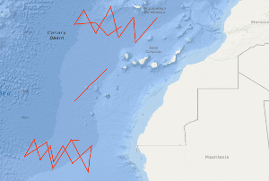
A geophysical reconnaissance survey across oceanic fracture zones has been carried out by the BGR in the eastern North Atlantic using S.V. PROSPEKTA. The geophysical measurements, including multichannel seismic reflection profiling, magnetics and gravity were concentrated on three oceanic crustal areas of Mesozoic crust which are crossed by the Hayes Fracture Zone, the Atlantis Fracture Zone and the Kane Fracture Zone respectively. 24 geophysical lines with a total length of 5,362 km have been measured during the time period from 25th October to 4th December 1985. Besides intracrustal seismic events a deep coherent seismic event is often recognizable in the monitor records between 10 - 12 s (TWT) along several lines, which probably is a reflection from the crust-mantle boundary. Im östlichen Nordatlantik sind von der BGR ozeanische Bruchzonen (Fracture Zones) übersichtsmaßig geophysikalisch vermessen worden. Die geophysikalischen Messungen, die digitale Reflexionsseismik, Magnetik und Gravimetrie einschlossen, sind mit S.V. PROSPEKTA in drei ozeanischen Krustengebieten mesozoischen Alters ausgefuhrt worden, die von den Bruchzonen der Hayes Fracture Zone, Atlantis Fracture Zone und Kane Fracture Zone gequert werden. Es sind 24 Profile mit einer Gesamtlénge von 5.362 km im Zeitraum vom 25. Oktober bis zum 4. Dezember 1985 vermessen worden. In den Monitorregistrierungen sind neben intrakrustalen seismischen Ereignissen haufig tiefe koharente seismische Ereignisse zwischen 10 und 12 sec (Reflexionszeit) erkennbar, die wahrscheinlich Reflexionen von der Grenzflache Kruste — Erdmantel reprasentieren.
Raumbezug
Lage der Geodaten (in WGS84)
| SW Länge/Breite | NO Länge/Breite | |
|---|---|---|
| -26.342°/19.086° | -15.37°/32.788° |
| Koordinatensystem |
|---|
Verweise und Downloads
Weitere Verweise (16)
| Identifikator des übergeordneten Metadatensatzes |
06a73c56-06a2-40d8-b806-466222b0760d |
|---|
Nutzung
| Nutzungsbedingungen |
Allgemeine Geschäftsbedingungen, siehe http://www.bgr.bund.de/AGB - General terms and conditions, see http://www.bgr.bund.de/AGB_en. Die bereitgestellten Informationen sind bei Weiterverwendung wie folgt zu zitieren: Datenquelle: BGR85 1985, (c) BGR, Hannover, 1985 |
|---|
| Zugriffsbeschränkungen |
no limitations to public access |
|---|
Kontakt
Fachinformationen
Informationen zum Datensatz
| Identifikator |
c91b531e-9344-e44d-097c-3a2697556f52 |
|---|
| Digitale Repräsentation |
Vector |
|---|
| Fachliche Grundlage |
During the period from the 25th October to the 4th December 1985 BGR acquired 24 seismic lines off West Africa in the Canary Basin at the Hayes, Atlantis and Kane Fracture Zones. The lines from BGR85-01B to BGR85-15 consist of raw data, the lines BGR85-23, BGR85-24A, BGR85-24B and BGR85-25 are stacked data, the lines BGR85-16, BGR85-17, BGR85-18, BGR85-19B, BGR85-20A, BGR85-20B, BGR85-21, BGR85-22, BGR85-26, BGR85-27 and BGR85-28 are migrated data. |
|---|
Zusatzinformationen
| Sprache des Datensatzes |
Englisch |
|---|
Konformität
| Spezifikation der Konformität | Spezifikationsdatum | Grad der Konformität | Geprüft mit |
|---|---|---|---|
| VERORDNUNG (EG) Nr. 1089/2010 DER KOMMISSION vom 23. November 2010 zur Durchführung der Richtlinie 2007/2/EG des Europäischen Parlaments und des Rates hinsichtlich der Interoperabilität von Geodatensätzen und -diensten | 08.12.2010 | siehe dazu die angegebene Durchführungsbestimmung |
Datenformat
| Name | Version | Kompressionstechnik | Spezifikation |
|---|---|---|---|
| Shapefile | n/a |
Schlagworte
| INSPIRE-Themen | Geology |
| GEMET-Concepts | geophysics Geophysik raw material Rohstoff |
| ISO-Themenkategorien | Geoscientific Information |
| Suchbegriffe | Atlantis Fracture Zone Canary Basin Hayes Fracture Zone Kanarenbecken Kane Fracture Zone Marine geology Meeresgeologie Nordost-Atlantik Northeast Atlantic Ocean Seismics |
Informationen zum Metadatensatz
| Objekt-ID |
045ca385-098f-46c2-a117-4ccaa96f6967 |
|---|
| Aktualität der Metadaten |
14.11.2023 |
|---|
| Sprache Metadatensatz |
Englisch |
|---|
| Datensatz / Datenserie |
Dataset |
|---|
| XML Darstellung |
|---|
| Point of Contact (Metadatum) |
|---|
| Metadatenquelle |
GeoDaK (Datenkatalog der Bundesanstalt für Geowissenschaften und Rohstoffe)
|
|---|---|
|
Bundesanstalt für Geowissenschaften und Rohstoffe
|


