Suche Karten Messwerte Kataloge Über NUMIS Anbieter Datenquellen API
Hilfe Kontakt Inhalt Impressum Datenschutz Barrierefreiheit
NUMIS - Das niedersächsische Umweltportal NUMIS - Das niedersächsische Umweltportal
Suche
Karten
Messwerte
Kataloge
API
Alle Suchergebnisse
Geodatensatz

Processed seismic data of Cruise BGR01 POPSCOMS 2001

Inhalt
  • Übersicht
  • Be­schrei­bung
    Aktualität des Datensatzes
  • Raumbezug
  • Verweise und Downloads
    Downloads Weitere Verweise
  • Nutzung
  • Kontakt
    Point of Contact
  • Fach­informationen
    Informationen zum Datensatz Zusatzinformationen Schlag­worte
  • Metadatensatz

Downloads (1)

BGR01 POPSCOMS 2001 (Shapefile) BGR01 POPSCOMS 2001 im Format ESRI Shape [1.0 MB]

Nutzungs­bedingun­gen

Allgemeine Geschäftsbedingungen, siehe http://www.bgr.bund.de/AGB - General terms and conditions, see http://www.bgr.bund.de/AGB_en. Die bereitgestellten Informationen sind bei Weiterverwendung wie folgt zu zitieren: Datenquelle: BGR01 POPSCOMS 2001, (c) BGR, Hannover, 2019

Point of Contact

Federal Institute for Geosciences and Natural Resources

Marine_Seismik@bgr.de

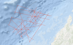
Vorschau

img

Be­schrei­bung

BGR01 POPSCOMS 2001

The main objectives of the BGR cruise BGR01 POPSCOMS (Properties of a Gas Hydrate Province on a Subduction-Collision Related Margin off Sabah) off Sabah/Malaysia with M/V AKADEMIK NEMCHINOV from 4th November to 3rd December 2001 in co-operation with PETRONAS Malaysia are the research on (1) Marine Methane Gas Hydrates: Detection, distribution and formation; relation to the adjacent highly productive "conventional" gas province in the specific tectonic setting of the collisional belt off Sabah. (2) Tectonic development of the (accretionary) margin off Sabah: Improve the tectonic stratigraphic hypothesis of the subducted Proto-South-China-Sea and continental crust under the accretionary wedge, respectively in the subducted plate. Open questions and targets of the survey: Within the help of the already existing magnetic data and other seismic measurement methods (e.g. special refraction seismic with ocean-bottom hydrophones [OBH], which presumably is an exellent and adequate method) we try to discern between oceanic and continental crust in the subducted plate, to investigate the nature of the transition and get information on the subduction angle. This is important in relation to the Cagayan Ridge (Sulu Sea) that is interpreted as an island arc that is related to the subduction of the proto-South China Sea. Another aim was to enable the determination of seismic anisotropy, distribution of BSR's and hydrates in the area and their v(p) to v(s) ratios. Are the gas hydrates related to the adjacent highly productive "conventional" gas province? What is the structural character of the transition zone between the hydrate province and the adjacent conventional gas bearing province further up-slope? Conversely, are there indication for a possible deepwater source? Can initial conclusions be drawn regarding their biogenic or thermogenic origin? Is there an impact of sedimentation conditions, compressional behaviour (e.g. at active margins) and/or structural properties on the genesis and stability of gas hydrates and BSRs (Bottom Simulating Reflectors)? How do the findings under different conditions compare in that regard? Which are the favorable conditions for the genesis of gas hydrates, and can they be detected by geophysical methods even if there are no BSR's? The findings are expected to provide a contribution to the assessment of the deepwater hydrocarbon potential along the continental margin off Sabah. Results: In the study area the BSRs were identified on the base of their polarity reversal with respect to the seafloor and when they transect reflectors from the strata. The widely distributed BSRs along the seismic lines of the survey deliver an indirect indicator for the presence of gas hydrates in the study area (BSR's in post Miocene sediments). The BSR depths below seafloor vary between 250 and 350 m. Differences in the reflection coefficient of the BSRs are mainly related to the amount of free gas beneath the Gas Hydrate Stability Zone. Hauptziele der Fahrt BGR01 POPSCOMS (Properties of a Gas Hydrate Province on a Subduction-Collision Related Margin off Sabah) vor Sabah/Malaysia mit der M/S AKADEMIK NEMCHINOV vom 4. November bis zum 3. Dezember 2001 in Kooperation mit PETRONAS Malaysia sind die Erforschung von (1) Marinen Gashydraten: Entdeckung, Verteilung und Bildung sowie deren Beziehung zu den benachbarten hochproduktiven "konventionellen" Gasvorkommen in der speziellen tektonischen Situation des Kollisionsbereichs vor Sabah, (2) Tektonische Entwicklung des Akkretionsrandes vor Sabah: Unterstützung der bisherigen Vermutungen über die Tektonik und Stratigraphie des subduzierten frühzeitlichen Südchinesischen Meeres und der kontinentalen Kruste unter dem Akkretionskeil und insbesondere in der subduzierten Platte durch weitere Messungen. Offene Fragen und Ziele der Fahrt: Mithilfe von vorhandenen Magnetfelddaten und zusätzlichen seismischen Messungen (z.B. Refraktionsseismik mit am Meeresboden verankerten OBH (ocean bottom hydrophone) Systemen) soll die ozeanische von der kontinentalen Kruste in der subduzierten Platte unterschieden werden und der Subduktionsvorgang sowie der Subduktionswinkel ermittelt werden. Da der Cagayan-Rücken in der Sulu-See als Inselbogen interpretiert wird, der von der Subduktion des frühen Südchinesischen Meeres hervorgerufen wurde, ist ein Vergleich der beiden Gebiete von wissenschaftlichem Interesse. Ein weiteres Ziel der Fahrt ist die Ermittlung der seismischen Anisotropie, der Verteilung von BSRs (bottom simulating reflectors), die das Vorkommen von Gashydraten in diesem Gebiet anzeigen sowie das Verhältnis von Kompressions- zu Scherwellengeschwindigkeiten. Folgende Resultate konnten aus den Messungen ermittelt werden: Im Untersuchungsgebiet wurden die BSRs anhand deren Polaritätsumkehr im Vergleich zum Meeresboden identifiziert sowie durch das Durchkreuzen von sedimentären Reflektoren. Die in den Seismikprofilen vielfach erkennbaren BSRs liefern einen indirekten Hinweis auf das Vorkommen von Gashydraten im Untersuchungsgebiet in den Sedimenten, die zeitlich nach dem Miozän abgelagert wurden. Die Tiefen der BSRs unterhalb des Meeresbodens betragen zwischen 250 und 350 m. Unterschiede im Reflexionskoeffizienten der BSRs sind hauptsächlich auf den Anteil des freien Gases unterhalb der Gashydratstabilitätszone zurückzuführen.

Aktualität des Datensatzes

Creation

03.12.2001

Status

completed

Raumbezug

Lage der Geodaten (in WGS84)
SW Länge/Breite NO Länge/Breite
113.914°/5.772° 115.917°/7.507°
Koordinaten­system
EPSG:4326

Verweise und Downloads

Downloads (1)

BGR01 POPSCOMS 2001 (Shapefile) BGR01 POPSCOMS 2001 im Format ESRI Shape [1.0 MB]

Weitere Verweise (31)

http://www.geo-seas.eu/v_cdi_v3/print_ajax.asp?n_code=1299442 Information Profile BGR01-01
http://www.geo-seas.eu/v_cdi_v3/print_ajax.asp?n_code=1299443 Information Profile BGR01-02
http://www.geo-seas.eu/v_cdi_v3/print_ajax.asp?n_code=1299444 Information Profile BGR01-03
http://www.geo-seas.eu/v_cdi_v3/print_ajax.asp?n_code=1299445 Information Profile BGR01-04
http://www.geo-seas.eu/v_cdi_v3/print_ajax.asp?n_code=1299446 Information Profile BGR01-05
http://www.geo-seas.eu/v_cdi_v3/print_ajax.asp?n_code=1299447 Information Profile BGR01-06
http://www.geo-seas.eu/v_cdi_v3/print_ajax.asp?n_code=1299448 Information Profile BGR01-07
http://www.geo-seas.eu/v_cdi_v3/print_ajax.asp?n_code=1299449 Information Profile BGR01-08
http://www.geo-seas.eu/v_cdi_v3/print_ajax.asp?n_code=1299450 Information Profile BGR01-09
http://www.geo-seas.eu/v_cdi_v3/print_ajax.asp?n_code=1299451 Information Profile BGR01-10
http://www.geo-seas.eu/v_cdi_v3/print_ajax.asp?n_code=1299452 Information Profile BGR01-11
http://www.geo-seas.eu/v_cdi_v3/print_ajax.asp?n_code=1299453 Information Profile BGR01-12
http://www.geo-seas.eu/v_cdi_v3/print_ajax.asp?n_code=1299454 Information Profile BGR01-A1
http://www.geo-seas.eu/v_cdi_v3/print_ajax.asp?n_code=1299455 Information Profile BGR01-A2
http://www.geo-seas.eu/v_cdi_v3/print_ajax.asp?n_code=1299456 Information Profile BGR01-A3A
http://www.geo-seas.eu/v_cdi_v3/print_ajax.asp?n_code=1299457 Information Profile BGR01-A3
http://www.geo-seas.eu/v_cdi_v3/print_ajax.asp?n_code=1299458 Information Profile BGR01-A4
http://www.geo-seas.eu/v_cdi_v3/print_ajax.asp?n_code=1299459 Information Profile BGR01-A5
http://www.geo-seas.eu/v_cdi_v3/print_ajax.asp?n_code=1299460 Information Profile BGR01-A6
http://www.geo-seas.eu/v_cdi_v3/print_ajax.asp?n_code=1299461 Information Profile BGR01-A7A
http://www.geo-seas.eu/v_cdi_v3/print_ajax.asp?n_code=1299462 Information Profile BGR01-A7
http://www.geo-seas.eu/v_cdi_v3/print_ajax.asp?n_code=1299463 Information Profile BGR01-B1
http://www.geo-seas.eu/v_cdi_v3/print_ajax.asp?n_code=1299464 Information Profile BGR01-B2
http://www.geo-seas.eu/v_cdi_v3/print_ajax.asp?n_code=1299465 Information Profile BGR01-B3
http://www.geo-seas.eu/v_cdi_v3/print_ajax.asp?n_code=1299466 Information Profile BGR01-B4
http://www.geo-seas.eu/v_cdi_v3/print_ajax.asp?n_code=1299467 Information Profile BGR01-B5A
http://www.geo-seas.eu/v_cdi_v3/print_ajax.asp?n_code=1299468 Information Profile BGR01-B6
http://www.geo-seas.eu/v_cdi_v3/print_ajax.asp?n_code=1299469 Information Profile BGR01-B7
http://www.geo-seas.eu/v_cdi_v3/print_ajax.asp?n_code=1299470 Information Profile BGR01-B8
http://www.geo-seas.eu/v_cdi_v3/print_ajax.asp?n_code=1299471 Information Profile BGR01-B9
https://services.bgr.de/geophysik/mssp Information Karte im BGR-Geoviewer
Identifikator des über­geordneten Metadaten­satzes

06a73c56-06a2-40d8-b806-466222b0760d

Nutzung

Nutzungs­bedingun­gen

Allgemeine Geschäftsbedingungen, siehe http://www.bgr.bund.de/AGB - General terms and conditions, see http://www.bgr.bund.de/AGB_en. Die bereitgestellten Informationen sind bei Weiterverwendung wie folgt zu zitieren: Datenquelle: BGR01 POPSCOMS 2001, (c) BGR, Hannover, 2019

Zugriffs­beschränkun­gen

no limitations to public access

Kontakt

Point of Contact

Federal Institute for Geosciences and Natural Resources

Stilleweg 2
30655 Hannover

Marine_Seismik@bgr.de

Fach­informationen

Informationen zum Datensatz

Identifikator

6331ded2-8dc9-91bf-7338-e920ec362ae1

Digitale Repräsentation

Vector

Fachliche Grundlage

In the period from 4th November to 3rd December 2001 BGR acquired seismic lines in the South China Sea and Eastern Archipelagic Seas during cruise BGR01 with M/V AKADEMIK NEMCHINOV. All lines BGR01-01, BGR01-02, BGR01-03, BGR01-04, BGR01-015, BGR01-06, BGR01-07, BGR01-08, BGR01-09, BGR01-11, BGR01-12, BGR01-A1, BGR01-A2, BGR01-A3, BGR01-A3A, BGR01-A4, BGR01-A5, BGR01-A6, BGR01-A7, BGR01-A7A, BGR01-B1, BGR01-B2, BGR01-B3, BGR01-B4, BGR01-B5A, BGR01-B6, BGR01-B7, BGR01-B8 and BGR01-B9 are migrated data.

Zusatzinformationen

Sprache des Daten­satzes

Englisch

Kon­formi­tät
Spezifi­kation der Kon­formi­tät Spezifi­kations­datum Grad der Kon­formi­tät Geprüft mit
VERORDNUNG (EG) Nr. 1089/2010 DER KOMMISSION vom 23. November 2010 zur Durchführung der Richtlinie 2007/2/EG des Europäischen Parlaments und des Rates hinsichtlich der Interoperabilität von Geodatensätzen und -diensten 08.12.2010 siehe dazu die angegebene Durchführungsbestimmung
Datenformat
Name Version Kompressionstechnik Spezifi­kation
Shapefile n/a

Schlag­worte

INSPIRE-Themen Geology
GEMET-Concepts geophysics Geophysik raw material Rohstoff
ISO-Themen­kategorien Geoscientific Information
Suchbegriffe Marine geology Meeresgeologie Palawan Trough Palawan-Rinne Seismics Seismik South China Sea Südchinesisches Meer Two-dimensional seismic reflection zweidimensionale Reflektionsseismik

Informationen zum Metadatensatz

Objekt-ID

299f631c-566b-4e42-a3a9-0568d09cf5a9

Aktualität der Metadaten

16.11.2023

Sprache Metadatensatz

Englisch

Datensatz / Datenserie  

Dataset

XML Dar­stellung
Metadaten als XML herunter­laden
Point of Contact (Metadatum)
geodatenmanagement@bgr.de
Metadatenquelle
GeoDaK (Datenkatalog der Bundesanstalt für Geowissenschaften und Rohstoffe)
Bundesanstalt für Geowissenschaften und Rohstoffe

NUMIS - Das niedersächsische Umweltportal
Niedersächsisches Ministerium für Umwelt,
Energie und Klimaschutz
Hilfe Kontakt Inhalt Impressum Datenschutz Barrierefreiheit
Nach oben

Hilfe

NUMIS NUMIS
UVP UVP