Suche Karten Messwerte Kataloge Über NUMIS Anbieter Datenquellen API
Hilfe Kontakt Inhalt Impressum Datenschutz Barrierefreiheit
NUMIS - Das niedersächsische Umweltportal NUMIS - Das niedersächsische Umweltportal
Suche
Karten
Messwerte
Kataloge
API
Alle Suchergebnisse
Geodatensatz

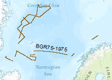
Processed seismic data of Cruise BGR 1975

Inhalt
  • Übersicht
  • Be­schrei­bung
    Aktualität des Datensatzes
  • Raumbezug
  • Verweise und Downloads
    Downloads Weitere Verweise
  • Nutzung
  • Kontakt
    Point of Contact
  • Fach­informationen
    Informationen zum Datensatz Zusatzinformationen Schlag­worte
  • Metadatensatz

Downloads (1)

BGR75 1975 (Shapefile) BGR75 1975 im Format ESRI Shape [1.0 MB]

Nutzungs­bedingun­gen

Allgemeine Geschäftsbedingungen, siehe https://www.bgr.bund.de/AGB - General terms and conditions, see https://www.bgr.bund.de/AGB_en. Die bereitgestellten Informationen sind bei Weiterverwendung wie folgt zu zitieren: Datenquelle: BGR75, (c) BGR, Hannover, 1975

Point of Contact

Federal Institute for Geosciences and Natural Resources

Marine_Seismik@bgr.de

Vorschau

img

Be­schrei­bung

BGR75 1975

Reconnaissance surveys were carried out in 1975 within the framework of the BGR program "Geoscientific studies in the North Atlantic". The data format is Society of Exploration Geophysicists SEG Y. The areas covered were the continental margin of Spitsbergen, the Barents Sea and the Norwegion continental margin. On the vessel LONGVA (30th August, 1975 - 29th September, 1975) multichannel seismic measurements were carried out on 37 lines with a total length of 2,815 km. Zur Erforschung der nordatlantischen Kontinentalränder und der benachbarten Tiefseeböden mit Hilfe modernster digitalseismischer Meßsysteme arbeitete die BGR ein Schwerpunktprogramm "Geowissenschaftliche Untersuchungen im Nord-Atlantik" aus. Die Daten liegen im Format der Society of Exploration Geophysicists SEG Y vor. Die geophysikalische Übersichtsvermessungen sind in der Norwegischen See, der Barents-See und im Seegebiet vor Spitzbergen durchgeführt worden. Es wurden 37 Profile auf einer Länge von 2.815km mit Hilfe des Forschungschiffes LONGVA (30.8.1975-29.9.1975) vermessen.

Aktualität des Datensatzes

Creation

29.09.1975

Status

completed

Raumbezug

Lage der Geodaten (in WGS84)
SW Länge/Breite NO Länge/Breite
-21.115°/68.129° 22.283°/76.139°
Koordinaten­system
EPSG:4326

Verweise und Downloads

Downloads (1)

BGR75 1975 (Shapefile) BGR75 1975 im Format ESRI Shape [1.0 MB]

Weitere Verweise (36)

http://www.geo-seas.eu/v_cdi_v3/print_ajax.asp?n_code=1299253 Information Profil BGR75-01
http://www.geo-seas.eu/v_cdi_v3/print_ajax.asp?n_code=1299254 Information Profil BGR75-02A
http://www.geo-seas.eu/v_cdi_v3/print_ajax.asp?n_code=1299255 Information Profil BGR75-05
http://www.geo-seas.eu/v_cdi_v3/print_ajax.asp?n_code=1299256 Information Profil BGR75-06
http://www.geo-seas.eu/v_cdi_v3/print_ajax.asp?n_code=1299257 Information Profil BGR75-07
http://www.geo-seas.eu/v_cdi_v3/print_ajax.asp?n_code=1299258 Information Profil BGR75-08
http://www.geo-seas.eu/v_cdi_v3/print_ajax.asp?n_code=1299259 Information Profil BGR75-09
http://www.geo-seas.eu/v_cdi_v3/print_ajax.asp?n_code=1299260 Information Profil BGR75-10
http://www.geo-seas.eu/v_cdi_v3/print_ajax.asp?n_code=1299261 Information Profil BGR75-11A
http://www.geo-seas.eu/v_cdi_v3/print_ajax.asp?n_code=1299262 Information Profil BGR75-12
http://www.geo-seas.eu/v_cdi_v3/print_ajax.asp?n_code=1299263 Information Profil BGR75-13
http://www.geo-seas.eu/v_cdi_v3/print_ajax.asp?n_code=1299264 Information Profil BGR75-14
http://www.geo-seas.eu/v_cdi_v3/print_ajax.asp?n_code=1299265 Information Profil BGR75-15
http://www.geo-seas.eu/v_cdi_v3/print_ajax.asp?n_code=1299266 Information Profil BGR75-16
http://www.geo-seas.eu/v_cdi_v3/print_ajax.asp?n_code=1299267 Information Profil BGR75-17
http://www.geo-seas.eu/v_cdi_v3/print_ajax.asp?n_code=1299268 Information Profil BGR75-18
http://www.geo-seas.eu/v_cdi_v3/print_ajax.asp?n_code=1299269 Information Profil BGR75-19
http://www.geo-seas.eu/v_cdi_v3/print_ajax.asp?n_code=1299270 Information Profil BGR75-20
http://www.geo-seas.eu/v_cdi_v3/print_ajax.asp?n_code=1299271 Information Profil BGR75-21
http://www.geo-seas.eu/v_cdi_v3/print_ajax.asp?n_code=1299272 Information Profil BGR75-22A
http://www.geo-seas.eu/v_cdi_v3/print_ajax.asp?n_code=1299273 Information Profil BGR75-22B
http://www.geo-seas.eu/v_cdi_v3/print_ajax.asp?n_code=1299274 Information Profil BGR75-23
http://www.geo-seas.eu/v_cdi_v3/print_ajax.asp?n_code=1299275 Information Profil BGR75-24
http://www.geo-seas.eu/v_cdi_v3/print_ajax.asp?n_code=1299276 Information Profil BGR75-26A
http://www.geo-seas.eu/v_cdi_v3/print_ajax.asp?n_code=1299277 Information Profil BGR75-26
https://download.bgr.de/bgr/marineseismik/info/message_na.html Information Profil BGR75-01A
https://download.bgr.de/bgr/marineseismik/info/message_na.html Information Profil BGR75-02
https://download.bgr.de/bgr/marineseismik/info/message_na.html Information Profil BGR75-03
https://download.bgr.de/bgr/marineseismik/info/message_na.html Information Profil BGR75-04
https://download.bgr.de/bgr/marineseismik/info/message_na.html Information Profil BGR75-07A
https://download.bgr.de/bgr/marineseismik/info/message_na.html Information Profil BGR75-08A
https://download.bgr.de/bgr/marineseismik/info/message_na.html Information Profil BGR75-11
https://download.bgr.de/bgr/marineseismik/info/message_na.html Information Profil BGR75-15A
https://download.bgr.de/bgr/marineseismik/info/message_na.html Information Profil BGR75-22
https://download.bgr.de/bgr/marineseismik/info/message_na.html Information Profil BGR75-25
https://services.bgr.de/geophysik/mssp Information Karte im BGR-Geoviewer
Identifikator des über­geordneten Metadaten­satzes

06a73c56-06a2-40d8-b806-466222b0760d

Nutzung

Nutzungs­bedingun­gen

Allgemeine Geschäftsbedingungen, siehe https://www.bgr.bund.de/AGB - General terms and conditions, see https://www.bgr.bund.de/AGB_en. Die bereitgestellten Informationen sind bei Weiterverwendung wie folgt zu zitieren: Datenquelle: BGR75, (c) BGR, Hannover, 1975

Zugriffs­beschränkun­gen

no limitations to public access

Kontakt

Point of Contact

Federal Institute for Geosciences and Natural Resources

Stilleweg 2
30655 Hannover

Marine_Seismik@bgr.de

Fach­informationen

Informationen zum Datensatz

Identifikator

544495f0-fbf3-4e01-83ca-e52cc236f870

Digitale Repräsentation

Vector

Fachliche Grundlage

During the period from 29th of August to 29th of September 1975 BGR aquired seismic lines in the North Atlantic. The lines BGR75-01, BGR75-02A, BGR75-05, BGR75-06, BGR75-07, BGR75-08, BGR75-09, BGR75-10, BGR75-11A, BGR75-12, BGR75-13, BGR75-14, BGR75-15, BGR75-16, BGR75-17, BGR75-18, BGR75-19, BGR75-20, BGR75-21, BGR75-22A, BGR75-22B, BGR75-23, BGR75-24, BGR75-26, BGR75-26A are processed (stack) data and BGR75-01A, BGR75-02, BGR75-03, BGR75-04, BGR75-07A, BGR75-08A, BGR75-11, BGR75-15A, BGR75-22, BGR75-25 are raw data.

Zusatzinformationen

Sprache des Daten­satzes

Englisch

Kon­formi­tät
Spezifi­kation der Kon­formi­tät Spezifi­kations­datum Grad der Kon­formi­tät Geprüft mit
VERORDNUNG (EG) Nr. 1089/2010 DER KOMMISSION vom 23. November 2010 zur Durchführung der Richtlinie 2007/2/EG des Europäischen Parlaments und des Rates hinsichtlich der Interoperabilität von Geodatensätzen und -diensten 08.12.2010 siehe dazu die angegebene Durchführungsbestimmung
Datenformat
Name Version Kompressionstechnik Spezifi­kation
Shapefile n/a

Schlag­worte

INSPIRE-Themen Geology
GEMET-Concepts geophysics Geophysik marine geology Meeresgeologie raw material Rohstoff
ISO-Themen­kategorien Geoscientific Information
Suchbegriffe Barentssea Barentssee MSSP Nordatlantik North Atlantic seismics Seismik two-dimensional seismic reflection zweidimensionale Reflektionsseismik

Informationen zum Metadatensatz

Objekt-ID

dd4fd1fa-4371-4afa-939c-f02a4a64d64a

Aktualität der Metadaten

07.04.2025

Sprache Metadatensatz

Englisch

Datensatz / Datenserie  

Dataset

XML Dar­stellung
Metadaten als XML herunter­laden
Point of Contact (Metadatum)
geodatenmanagement@bgr.de
Metadatenquelle
GeoDaK (Datenkatalog der Bundesanstalt für Geowissenschaften und Rohstoffe)
Bundesanstalt für Geowissenschaften und Rohstoffe

NUMIS - Das niedersächsische Umweltportal
Niedersächsisches Ministerium für Umwelt,
Energie und Klimaschutz
Hilfe Kontakt Inhalt Impressum Datenschutz Barrierefreiheit
Nach oben

Hilfe

NUMIS NUMIS
UVP UVP