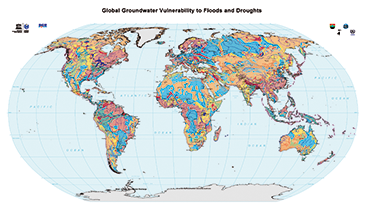
The World-wide Hydrogeological Mapping and Assessment Programme (WHYMAP) provides data and information about the earth´s major groundwater resources. The Map of Global Groundwater Vulnerability to Floods and Droughts indicates the vulnerability level of groundwater resources of the earth. It presents the intrinsic vulnerability of groundwater systems and the sensitivity or resistance of those systems to natural disasters. Das World-wide Hydrogeological Mapping and Assessment Programme (WHYMAP) stellt Daten und Informationen über die weltweiten Grundwasservorkommen bereit. Die Karte der Globalen Grundwassergefährdung durch Hochwasser und Dürre beschreibt die Empfindlichkeit bzw. Widerstandsfähigkeit der Grundwasservorkommen auf der Erde gegenüber diesen Naturkatastrophen.
Raumbezug
Lage der Geodaten (in WGS84)
| SW Länge/Breite | NO Länge/Breite | |
|---|---|---|
| -180.0°/-90.0° | 180.0°/90.0° |
| Koordinatensystem |
|---|
Verweise und Downloads
Querverweise (1)
WMS
Geodatendienst
Global Groundwater Vulnerability to Floods and Droughts (WHYMAP GWV) (WMS)
The World-wide Hydrogeological Mapping and Assessment Programme (WHYMAP) provides data and information about the earth´s major groundwater resources. The Map of Global Groundwater Vulnerability to Floods and Droughts indicates the vulnerability level of groundwater resources of the earth. It presents the intrinsic vulnerability of groundwater systems and the sensitivity or resistance of those systems to natural disasters.
Kartenansicht öffnen
Weitere Verweise (2)
https://services.bgr.de/grundwasser/whymap_gwv
Information
Karte im BGR-Geoviewer
Website
Information
Nutzung
| Nutzungsbedingungen |
Allgemeine Geschäftsbedingungen, s.: https://www.bgr.bund.de/AGB - General terms and conditions, s. https://www.bgr.bund.de/AGB_en; Die bereitgestellten Informationen sind bei Weiterverwendung wie folgt zu zitieren: Datenquelle: WHYMAP, (C) BGR Hannover & UNESCO Paris |
|---|
| Zugriffsbeschränkungen |
no limitations to public access |
|---|
Kontakt
Fachinformationen
Informationen zum Datensatz
| Identifikator |
3a16e5a7-c473-442b-88b4-6ee1ff20b98b |
|---|
| Digitale Repräsentation |
Vector |
|---|
Erstellungsmaßstab
| Maßstab 1:x |
25000000 |
|---|
| Fachliche Grundlage |
World-wide Hydrogeological Mapping and Assessment Programme (WHYMAP) |
|---|
Zusatzinformationen
| Sprache des Datensatzes |
Englisch |
|---|
Datenformat
| Name | Version | Kompressionstechnik | Spezifikation |
|---|---|---|---|
| Shapefile | n/a |
Schlagworte
| INSPIRE-Themen | Geology |
| GEMET-Concepts | Groundwater Grundwasser Hydrogeologie Hydrogeology |
| ISO-Themenkategorien | Geoscientific Information |
| Suchbegriffe | Aquifer Groundwater abstraction Groundwater recharge Groundwater resources Grundwasserentnahme Grundwasserneubildung Grundwasservorkommen Weltweit World-wide |
Informationen zum Metadatensatz
| Objekt-ID |
0cf5c86b-ac00-4c3d-845b-792f8bdce023 |
|---|
| Aktualität der Metadaten |
12.03.2025 |
|---|
| Sprache Metadatensatz |
Englisch |
|---|
| Datensatz / Datenserie |
Dataset |
|---|
| XML Darstellung |
|---|
| Point of Contact (Metadatum) |
|---|
| Metadatenquelle |
GeoDaK (Datenkatalog der Bundesanstalt für Geowissenschaften und Rohstoffe)
|
|---|---|
|
Bundesanstalt für Geowissenschaften und Rohstoffe
|


