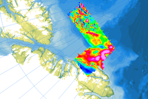
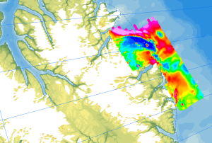
As part of the PMAP-CASE (Polar Margin Aeromagnetic Program - Circum-Arctic Structural Events) expeditions, two surveys were conducted in consecutive seasons in 1997 and 1998. Cooperating partners were the Department of National Defence (DND), GSC Ottawa and the Institute for Aerospace Research Ottawa (IAR-NRC). The surveys covered the areas of the northern continental margin of Greenland including the northern Nansen Land and western Johannes V. Jensen Land, as well as parts of the Lincoln Sea. The objective of the campaigns was to investigate the structures of the upper crust of the Morris Jesup Plateau and the correlation of magnetic anomalies with known structures and geologic units on land (Franklinian Basin, Kap Washington volcanics, and volcanic dyke swarms). Airborne magnetic surveys (Convair 580) were conducted with a 3 km flight line spacing, and control lines were flown every 30 km. Data were recorded at a constant flight altitude of 300 m above ground. Approximately 30000 km of line data were collected during the two expeditions, covering an area of 73000 km². Im Rahmen der Expeditionen PMAP-CASE (Polar Margin Aeromagnetic Program – Circum-Arctic Structural Events) wurden zwei Befliegungen in den aufeinanderfolgenden Saisons 1997 und 1998 durchgeführt. Kooperationspartner waren das Department of National Defence (DND), der GSC Ottawa und das Institute for Aerospace Research Ottawa (IAR-NRC). Die Befliegungen deckten Bereiche des nördlichen Kontinentalrandes von Grönland im nördlichen Nansen Land und im westlichen Johannes V. Jensen Land sowie Teile der Lincolnsee ab. Ziele der Befliegungen waren die Untersuchungen der Strukturen und des Aufbaus der oberen Erdkruste des Morris Jesup Plateaus und die Korrelation von magnetischen Anomalien mit bekannten Strukturen und geologischen Einheiten an Land (Franklin-Becken, Kap Washington Vulkanite und vulkanische Gangsysteme). Die flugzeuggestützten magnetischen Befliegungen (Convair 580) wurden jeweils mit einem Fluglinienabstand von 3 km durchgeführt, und alle 30 km wurden Kontrollprofile geflogen. Die Daten wurden bei einer konstanten Flughöhe von 300 m über Grund aufgezeichnet. Während der beiden Expeditionen wurden ca. 30000 km Liniendaten erfasst, die eine Fläche von 73000 km² abdecken.
Raumbezug
Lage der Geodaten (in WGS84)
| SW Länge/Breite | NO Länge/Breite | |
|---|---|---|
| -109.97°/78.74° | -31.07°/85.75° |
| Koordinatensystem |
|---|
Verweise und Downloads
Downloads (2)
AeromagPMAP_97_98 (GeoTIFF)
AeromagPMAP_97_98 im Format geoTiff
Flightlines (Shape)
Flightlines im Format Shape
Querverweise (1)
WMS
Geodatendienst
Helicopter-borne Magnetics in the Arctic region (WMS)
The study of the geodynamic evolution of the Arctic continental margin and opening of the Arctic Ocean represents a primary target of BGR research and is studied within the frame of the CASE programme. In addition to onshore geological investigations, BGR conducts airborne aeromagnetic surveys. The available service contains the results of aeromagnetic surveys from the CASE program as well as cooperation projects (PMAP, NARES & NOGRAM), which were obtained with helicopters or fixed-wing aircraft in the Arctic.
Kartenansicht öffnen
Weitere Verweise (2)
https://services.bgr.de/geophysik/aeromagarctic
Information
Karte im BGR-Geoviewer
https://www.bgr.bund.de/DE/Themen/Polarforschung/Arktis/arktis_node.html
Information
Arktisforschung der BGR
| Identifikator des übergeordneten Metadatensatzes |
e85d6dcc-91b8-48bc-a80d-7ca0f9546cda |
|---|
Nutzung
| Nutzungsbedingungen |
Allgemeine Geschäftsbedingungen, siehe https://www.bgr.bund.de/AGB - General terms and conditions, see https://www.bgr.bund.de/AGB_en. Die bereitgestellten Informationen sind bei Weiterverwendung wie folgt zu zitieren: Datenquelle: AeromagPMAP-CASE, (c) BGR, Hannover, 2023 |
|---|
| Zugriffsbeschränkungen |
no limitations to public access |
|---|
Kontakt
Fachinformationen
Informationen zum Datensatz
| Identifikator |
aa329603-372d-e3ea-b613-5c047fd9f383 |
|---|
| Fachliche Grundlage |
The aeromagnetic data were collected by Department of National Defence (DND), GSC Ottawa, the Institute for Aerospace Research Ottawa (IAR-NRC), and BGR as part of the CASE program on the PMAP-CASE expeditions north of Greenland. |
|---|
Zusatzinformationen
| Sprache des Datensatzes |
Englisch |
|---|
Datenformat
| Name | Version | Kompressionstechnik | Spezifikation |
|---|---|---|---|
| GeoTIFF | n/a | ||
| shp | n/a | ||
| WMS | OGC:WMS1.3.0 |
Schlagworte
| INSPIRE-Themen | Geology |
| GEMET-Concepts | Geophysik |
| ISO-Themenkategorien | Geoscientific Information |
| Suchbegriffe | Aerogeophysik Aeromagnetik Airborne geophysics Anomalien des erdmagnetischen Feldes anomalies of the Earth’s magnetic field Arctic Arktis helicopter-borne /fixed-wing magnetics Nordpolargebiet North Polar |
Informationen zum Metadatensatz
| Objekt-ID |
e08bd240-2443-4c38-9876-2db0b35e02b7 |
|---|
| Aktualität der Metadaten |
07.04.2025 |
|---|
| Sprache Metadatensatz |
Englisch |
|---|
| Datensatz / Datenserie |
Dataset |
|---|
| XML Darstellung |
|---|
| Point of Contact (Metadatum) |
|---|
| Metadatenquelle |
GeoDaK (Datenkatalog der Bundesanstalt für Geowissenschaften und Rohstoffe)
|
|---|---|
|
Bundesanstalt für Geowissenschaften und Rohstoffe
|


