Suche Karten Messwerte Kataloge Über NUMIS Anbieter Datenquellen API
Hilfe Kontakt Inhalt Impressum Datenschutz Barrierefreiheit
NUMIS - Das niedersächsische Umweltportal NUMIS - Das niedersächsische Umweltportal
Suche
Karten
Messwerte
Kataloge
API
Alle Suchergebnisse
Geodatendienst
INSPIRE
Open Data

INSPIRE: Unconventional hydrocarbons (Nicht-konventionelle KW) (WMS)

Inhalt
  • Übersicht
  • Be­schrei­bung
    Aktualität des Datensatzes
  • Raumbezug
  • Verweise und Downloads
    URL des Zugangs Querverweise Weitere Verweise
  • Nutzung
  • Kontakt
    Point of Contact Custodian
  • Fach­informationen
    Informationen zum Datensatz Zusatzinformationen Schlag­worte
  • Metadatensatz

URL des Zugangs (1)

https://services.bgr.de/wms/inspire_mr/niko/?REQUEST=GetCapabilities&SERVICE=WMS

Querverweise (1)

INSPIRE: Unconventional hydrocarbons (Nicht-konventionelle KW)
Nicht-konventionelle KW (INSPIRE) presents the results of the NiKo project according to data specifications Energy Resources (D2.8.III.20) und Geology (D2.8.II.4_v3.0). NiKo stands for „unconventional hydrocarbons“, „Nicht-konventionelle Kohlenwasserstoffe“ in German. In the NiKo project the Federal Institute for Geosciences and Natural Resources (BGR) has investigated the potential resources for shale oil and shale gas in Germany. The study was published in 2016 as a report titled „Schieferöl und Schiefergas in Deutschland – Ressourcen und Umweltaspekte“ (available in German only). The colloquial terms shale oil and shale gas refer to oil and natural gas resources in sedimentary shale rock formations, with high organic matter content. In the study, seven formations were identified to have a shale oil and/or gas potential in Germany and their distribution has been mapped in small scale. For each of the formations the organic-rich facies distribution is provided and, if appropriate, the regional potential resource distribution: Fischschiefer (Oligocene), Blättertone (Barremium - Lower-Aptian), Wealden (Berriasium), Posidonienschiefer (Lower-Toarcium), Middel-Rhaetium (Oberkeuper), Permokarbon (Stefanium - Rotliegend) und Lower Carboniferous (Upper Alaunschiefer (Kulm-Facies) + Kohlenkalk-Facies). Corresponding to the overview maps in the report two GML-files for these layers are provided, omitting however the sub-category “possible potential regions”. Bituminous facies distribution (0-5000 m Tiefe) – data specification Geology: GeologicUnit.Distribution_of_bituminous_facies.gml Distribution shale oil and shale gas – potential resources (1000 - 5000 m Tiefe) – data specification Energy Resources: FossilFuelRessource_Potential_resource_regions.gml The distribution maps of the potential resources for shale oil and gas are based on geoscientific criteria. Further non-geoscientific limiting criteria, e.g. exclusion areas, have not been taken into account for the assessment. These assessments are based on appraisements of input parameters naturally with large uncertainties for the potential resources and their distribution in the deep underground. Based on the incipient exploration status of unconventionals in Germany, these resources are considered as undiscovered. The assessed shale oil and gas resources for Germany, represent the order of magnitude of potential resources. Reference: BGR 2016 - Schieferöl und Schieferöl in Deutschland- Potenziale und Umweltaspekte https://www.bgr.bund.de/DE/Themen/Energie/Downloads/Abschlussbericht_13MB_Schieferoelgaspotenzial_Deutschland_2016.html

Nutzungs­bedingun­gen

Terms of Use: General terms and conditions, see https://www.bgr.bund.de/AGB_en. For further use provided information has to be cited as follows: NiKo-INSPIRE, (c) BGR Hannover, 2020

Point of Contact

Bundesanstalt für Geowissenschaften und Rohstoffe (BGR)

energierohstoffe@bgr.de

Vorschau

img

Kartenansicht öffnen

Be­schrei­bung

Nicht-koventionelle KW (WMS) (INSPIRE)

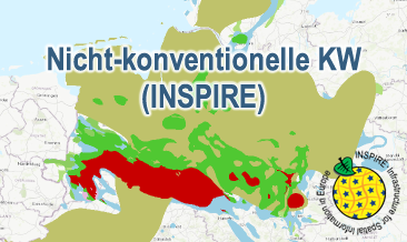
The WMS Nicht-konventionelle KW (INSPIRE) presents the results of the NiKo project according to data specifications Energy Resources (D2.8.III.20) und Geology (D2.8.II.4_v3.0). NiKo stands for „unconventional hydrocarbons“, „Nicht-konventionelle Kohlenwasserstoffe“ in German. In the NiKo project the Federal Institute for Geosciences and Natural Resources (BGR) has investigated the potential resources for shale oil and shale gas in Germany. The study was published in 2016 as a report titled „Schieferöl und Schiefergas in Deutschland – Ressourcen und Umweltaspekte“ (available in German only). The colloquial terms shale oil and shale gas refer to oil and natural gas resources in sedimentary shale rock formations, with high organic matter content. In the study, seven formations were identified to have a shale oil and/or gas potential in Germany and their distribution has been mapped in small scale. For each of the formations the organic-rich facies distribution is provided as layer and, if appropriate, the regional potential resource distribution: Fischschiefer (Oligocene), Blättertone (Barremium - Lower-Aptian), Wealden (Berriasium), Posidonienschiefer (Lower-Toarcium), Middel-Rhaetium (Oberkeuper), Permokarbon (Stefanium - Rotliegend) und Lower Carboniferous (Upper Alaunschiefer (Kulm-Facies) + Kohlenkalk-Facies). According to the overview maps in the report the following layers are provided, omitting however the sub-category “possible potential regions”. Bituminous facies distribution (0-5000 m depth) – data specification Geology: GE.GeologicUnit.Fischschiefer_distribution, GE.GeologicUnit.Blaettertone_distribution, GE.GeologicUnit.Wealden_distribution, GE.GeologicUnit.Posidonienschiefer_distribution, GE.GeologicUnit.Mittelrhaetium_black_shale_thicker_20m_distribution, GE.GeologicUnit.Permokarbon_black_shale_distribution, GE.GeologicUnit.Unterkarbon_Hangende_Alaunschiefer_distribution und GE.GeologicUnit.Unterkarbon_Kohlenkalk Facies layers are coloured according to the corresponding oldest formation age (olderNamedAge). Distribution shale oil and shale gas – potential resources (1000 - 5000 m depth) – data specification Energy Resources: ER.FossilFuelRessource.Blaettertone, ER.FossilFuelRessource.Wealden, ER.FossilFuelRessource.Posidonienschiefer, ER.FossilFuelRessource.Mittelrhaetschiefer, ER.FossilFuelRessource.Permokarbon und ER.FossilFuelRessource.Unterkarbon The shale oil and shale gas distribution layers are not coloured according to INSPIRE guidelines, but rather as common international practice in green and red, respectively. The distribution maps of the potential resources for shale oil and gas are based on geoscientific criteria. Further non-geoscientific limiting criteria, e.g. exclusion areas, have not been taken into account for the assessment. These assessments are based on appraisements of input parameters naturally with large uncertainties for the potential resources and their distribution in the deep underground. Based on the incipient exploration status of unconventionals in Germany, these resources are considered as undiscovered. The assessed shale oil and gas resources for Germany, represent the order of magnitude of potential resources. Source: BGR 2016 - Schieferöl und Schieferöl in Deutschland in 2016: - Potenziale und Umweltaspekte https://www.bgr.bund.de/DE/Themen/Energie/Downloads/Abschlussbericht_13MB_Schieferoelgaspotenzial_Deutschland_2016.html Der WMS Nicht-konventionelle KW (INSPIRE) stellt die Ergebnisse des Projektes NiKo (= Nicht-konventionelle Kohlenwasserstoffe) entsprechend der Datenspezifikationen Energy Resources (D2.8.III.20) und Geology (D2.8.II.4_v3.0) INSPIRE-konform dar. Die Bundesanstalt für Geowissenschaften und Rohstoffe (BGR) hat das Potenzial an Schieferöl und Schiefergas in Deutschland im Projekt NiKo untersucht und 2016 in der Studie „Schieferöl und Schiefergas in Deutschland – Ressourcen und Umweltaspekte“ veröffentlicht. Die umgangssprachlichen Begriffe Schieferöl und Schiefergas bezeichnen Erdöl- und Erdgasvorkommen in organisch-reichen (bituminösen) sedimentären Tongesteinen. In der Studie werden insgesamt sieben Formationen mit Schieferöl- und/oder Schiefergaspotenzial identifiziert und die Verbreitung der Potenzialgebiete kleinmaßstäblich erfasst. Für diese Formationen werden jeweils die Verbreitung der bitumösen Fazies und sofern zutreffend die Potenzialgebiete mit Schiefergas bzw. Schieferöl dargestellt: Fischschiefer (Oligozän), Blättertone (Barremium bis Unter-Aptium), Wealden (Berriasium), Posidonienschiefer (Unter-Toarcium), Mittel-Rhaetium (Oberkeuper), Permokarbon (Stefanium bis Rotliegend) und Unterkarbon (Hangender Alaunschiefer (Kulm-Fazies) + Kohlenkalk-Fazies). Entsprechend den Übersichtskarten in der Studie werden für diese Formationen die folgenden Layer zur Verfügung gestellt (Im Vergleich zu den Original-Daten werden die möglichen Potenzialgebiete mit Schiefergas bzw. Schieferöl nicht dargestellt.): Verbreitung der bituminösen Fazies (0-5000 m Tiefe) – Datenspezifikation Geology: GE.GeologicUnit.Fischschiefer_distribution, GE.GeologicUnit.Blaettertone_distribution, GE.GeologicUnit.Wealden_distribution, GE.GeologicUnit.Posidonienschiefer_distribution, GE.GeologicUnit.Mittelrhaetium_black_shale_thicker_20m_distribution, GE.GeologicUnit.Permokarbon_black_shale_distribution, GE.GeologicUnit.Unterkarbon_Hangende_Alaunschiefer_distribution und GE.GeologicUnit.Unterkarbon_Kohlenkalk Die einzelnen Fazies-Layer werden entsprechend der Farbe des Anfangalters (olderNamedAge) grafisch dargestellt. Verbreitung Schieferöl –und/oder Schiefergas - Potenzialgebiet (1000 - 5000 m Tiefe) – Datenspezifikation Energy Resources: ER.FossilFuelRessource.Blaettertone ER.FossilFuelRessource.Wealden, ER.FossilFuelRessource.Posidonienschiefer, ER.FossilFuelRessource.Mittelrhaetschiefer, ER.FossilFuelRessource.Permokarbon und ER.FossilFuelRessource.Unterkarbon Die Schieferöl- und Schiefergas-Potenzialgebiete werden nicht nach den INSPIRE-Richtlinien grafisch dargestellt, sondern – wie international üblich – grün bzw. rot dargestellt. Die Verbreitungskarten der Potenzialgebiete beruhen auf geowissenschaftlichen Kriterien. Bei den Abschätzungen nicht berücksichtigt sind weitere, nicht-geowissenschaftliche Kriterien, wie z.B. Ausschlussgebiete. Zugrunde liegen Abschätzungen, die naturgemäß mit Unsicherheiten über die möglichen Vorkommen und deren Verbreitung behaftet sind. Auf Grund des Erkundungsgrades der Vorkommen, sind die Ressourcen als nicht nachgewiesen (undiscovered) einzustufen. Die ermittelten Schieferöl- und Schiefergasressourcen in Deutschland geben die Größenordnung der Potenziale an. Referenz: BGR 2016 - Schieferöl und Schieferöl in Deutschland- Potenziale und Umweltaspekte https://www.bgr.bund.de/DE/Themen/Energie/Downloads/Abschlussbericht_13MB_Schieferoelgaspotenzial_Deutschland_2016.html
Aktualität des Datensatzes

Publication

20.10.2020

Status

completed

Raumbezug

Lage der Geodaten (in WGS84)
SW Länge/Breite NO Länge/Breite
5.56°/47.14° 15.58°/55.09°
Koordinaten­system
EPSG:25832

Verweise und Downloads

URL des Zugangs (1)

https://services.bgr.de/wms/inspire_mr/niko/?REQUEST=GetCapabilities&SERVICE=WMS

Querverweise (1)

Geodatensatz
INSPIRE: Unconventional hydrocarbons (Nicht-konventionelle KW)
img
Nicht-konventionelle KW (INSPIRE) presents the results of the NiKo project according to data specifications Energy Resources (D2.8.III.20) und Geology (D2.8.II.4_v3.0). NiKo stands for „unconventional hydrocarbons“, „Nicht-konventionelle Kohlenwasserstoffe“ in German. In the NiKo project the Federal Institute for Geosciences and Natural Resources (BGR) has investigated the potential resources for shale oil and shale gas in Germany. The study was published in 2016 as a report titled „Schieferöl und Schiefergas in Deutschland – Ressourcen und Umweltaspekte“ (available in German only). The colloquial terms shale oil and shale gas refer to oil and natural gas resources in sedimentary shale rock formations, with high organic matter content. In the study, seven formations were identified to have a shale oil and/or gas potential in Germany and their distribution has been mapped in small scale. For each of the formations the organic-rich facies distribution is provided and, if appropriate, the regional potential resource distribution: Fischschiefer (Oligocene), Blättertone (Barremium - Lower-Aptian), Wealden (Berriasium), Posidonienschiefer (Lower-Toarcium), Middel-Rhaetium (Oberkeuper), Permokarbon (Stefanium - Rotliegend) und Lower Carboniferous (Upper Alaunschiefer (Kulm-Facies) + Kohlenkalk-Facies). Corresponding to the overview maps in the report two GML-files for these layers are provided, omitting however the sub-category “possible potential regions”. Bituminous facies distribution (0-5000 m Tiefe) – data specification Geology: GeologicUnit.Distribution_of_bituminous_facies.gml Distribution shale oil and shale gas – potential resources (1000 - 5000 m Tiefe) – data specification Energy Resources: FossilFuelRessource_Potential_resource_regions.gml The distribution maps of the potential resources for shale oil and gas are based on geoscientific criteria. Further non-geoscientific limiting criteria, e.g. exclusion areas, have not been taken into account for the assessment. These assessments are based on appraisements of input parameters naturally with large uncertainties for the potential resources and their distribution in the deep underground. Based on the incipient exploration status of unconventionals in Germany, these resources are considered as undiscovered. The assessed shale oil and gas resources for Germany, represent the order of magnitude of potential resources. Reference: BGR 2016 - Schieferöl und Schieferöl in Deutschland- Potenziale und Umweltaspekte https://www.bgr.bund.de/DE/Themen/Energie/Downloads/Abschlussbericht_13MB_Schieferoelgaspotenzial_Deutschland_2016.html

Weitere Verweise (2)

https://services.bgr.de/inspire/niko Information Karte im BGR-Geoviewer
https://services.bgr.de/wms/inspire_mr/niko/?REQUEST=GetCapabilities&SERVICE=wms&VERSION=1.3.0

Nutzung

Nutzungs­bedingun­gen

Terms of Use: General terms and conditions, see https://www.bgr.bund.de/AGB_en. For further use provided information has to be cited as follows: NiKo-INSPIRE, (c) BGR Hannover, 2020

Dieser Datensatz kann gemäß der "Nutzungsbestimmungen für die Bereitstellung von Geodaten des Bundes" (https://sg.geodatenzentrum.de/web_public/gdz/lizenz/geonutzv.pdf) genutzt werden.

Zugriffs­beschränkun­gen

no limitations to public access

Kontakt

Point of Contact

Bundesanstalt für Geowissenschaften und Rohstoffe (BGR)

Stilleweg 2
30655 Hannover
DE

energierohstoffe@bgr.de
Custodian

Bundesanstalt für Geowissenschaften und Rohstoffe (BGR)

geodatenmanagement@bgr.de

Fach­informationen

Informationen zum Datensatz

Art des Dienstes

View Service

Version

OGC:WMS 1.3.0

Fachliche Grundlage

The WMS Nicht-konventionelle KW (INSPIRE) is based on the NiKo spatial datasets (Shale oil and shale gas in Germany – Potentials and environmental aspects) transformed according to INSPIRE.

Operation
Name der Operation Beschreibung der Operation Aufruf der Operation
GetCapabilities

https://services.bgr.de/wms/inspire_mr/niko/?

GetMap

https://services.bgr.de/wms/inspire_mr/niko/?

Get­Ca­pa­bi­li­ties Do­ku­ment
Get­Ca­pa­bi­li­ties an­zei­gen
Kartenansicht öffnen

Zusatzinformationen

Kon­formi­tät
Spezifi­kation der Kon­formi­tät Spezifi­kations­datum Grad der Kon­formi­tät Geprüft mit
Technical Guidance for the implementation of INSPIRE View Services 04.04.2013 See the referenced specification
VERORDNUNG (EG) Nr. 976/2009 DER KOMMISSION vom 19. Oktober 2009 zur Durchführung der Richtlinie 2007/2/EG des Europäischen Parlaments und des Rates hinsichtlich der Netzdienste 20.10.2009 See the referenced specification
Datenformat
Name Version Kompressionstechnik Spezifi­kation
png n/a
jpeg n/a
gif n/a

Schlag­worte

INSPIRE-Themen Energy resources
INSPIRE - Räumlicher An­wen­dungs­bereich National
GEMET-Concepts crude oil energy energy resource energy source energy source material fossil fuel natural gas oil shale shale gas
Suchbegriffe Deutschland Germany infoMapAccessService inspireidentifiziert opendata

Informationen zum Metadatensatz

Objekt-ID

e73e8a56-0454-4f58-8fc9-58847f4d8712

Aktualität der Metadaten

23.04.2025

Sprache Metadatensatz

Englisch

XML Dar­stellung
Metadaten als XML herunter­laden
Point of Contact (Metadatum)
geodatenmanagement@bgr.de
Metadatenquelle
GeoDaK (Datenkatalog der Bundesanstalt für Geowissenschaften und Rohstoffe)
Bundesanstalt für Geowissenschaften und Rohstoffe

NUMIS - Das niedersächsische Umweltportal
Niedersächsisches Ministerium für Umwelt,
Energie und Klimaschutz
Hilfe Kontakt Inhalt Impressum Datenschutz Barrierefreiheit
Nach oben

Hilfe

NUMIS NUMIS
UVP UVP