Suche Karten Messwerte Kataloge Über NUMIS Anbieter Datenquellen API
Hilfe Kontakt Inhalt Impressum Datenschutz Barrierefreiheit
NUMIS - Das niedersächsische Umweltportal NUMIS - Das niedersächsische Umweltportal
Suche
Karten
Messwerte
Kataloge
API
Alle Suchergebnisse
Geodatensatz

Processed seismic data of Cruise AUR 2003

Inhalt
  • Übersicht
  • Be­schrei­bung
    Aktualität des Datensatzes
  • Raumbezug
  • Verweise und Downloads
    Downloads Weitere Verweise
  • Nutzung
  • Kontakt
    Point of Contact
  • Fach­informationen
    Informationen zum Datensatz Zusatzinformationen Schlag­worte
  • Metadatensatz

Downloads (1)

AUR03 2003 (Shapefile) AUR03 2003 im Format ESRI Shape [1.0 MB]

Nutzungs­bedingun­gen

Allgemeine Geschäftsbedingungen, siehe https://www.bgr.bund.de/AGB - General terms and conditions, see https://www.bgr.bund.de/AGB_en. Die bereitgestellten Informationen sind bei Weiterverwendung wie folgt zu zitieren: Datenquelle: AUR03, (c) BGR, Hannover, 2003

Point of Contact

Federal Institute for Geosciences and Natural Resources

Marine_Seismik@bgr.de

Vorschau

img

Be­schrei­bung

AUR03 2003

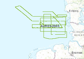
The late Tertiary and Quaternary development of the German EEZ was systematically inverstigated by seismic profiling. The data format is Society of Exploration Geophysicists SEG Y. For that survey the privately owned motor vessel AURELIA was chartered for a period of 24 days from the 16th of September to 10th of October 2003. A more or less equidistant E-W and N-S grid of profiles with a length of 2500 km was surveyed by high-resolution multichannel seismic system. A 0.82 litre GI-Gun was employed every 12.5 m and the reflected signals were recorded by a 300 m long streamer. Simultaneously a deep-towed HUNTEC-Boomer or a GEO-Sparker was run (150km/620km). All seismic records were processed onboard for the quality control and for a first interpretation. Die spättertiäre und quartäre Entwicklung des deutschen Nordsee-Sektors wurde mit seismischen Profilen systematisch erkundet. Die Daten liegen im Format der Society of Exploration Geophysicists SEG Y vor. Für die Vermessung wurde das Motorschiff "Aurelia" für 24 Tage vom 16. September bis 10. Oktober gechartert. Ein N-S und W-E gerichtetes, mehr oder weniger gleichmäßiges Profilnetz wurde mit einem hochauflösenden seismischen Multikanalsystem mit einer gesamten Profillänge von 2500 km vermessen. Dabei wurde eine GI-Gun alle 12,5 m eingesetzt und die seismischen Signale durch einen 300 m-langen Streamer aufgezeichnet. Ein tiefgeschleppter Huntec-Boomer und ein Geo-Sparker wurden auf einen Teil der Profile (150 km/620 km) zur Vermessung der quartären Deckschichten benutzt. Alle seismischen Profile wurden zur Qualitätskontrolle und für eine erste Auswertung prozessiert.

Aktualität des Datensatzes

Creation

10.10.2003

Status

completed

Raumbezug

Lage der Geodaten (in WGS84)
SW Länge/Breite NO Länge/Breite
3.373°/54.011° 8.314°/55.833°
Koordinaten­system
EPSG:4326

Verweise und Downloads

Downloads (1)

AUR03 2003 (Shapefile) AUR03 2003 im Format ESRI Shape [1.0 MB]

Weitere Verweise (45)

http://www.geo-seas.eu/v_cdi_v3/print_ajax.asp?n_code=1301958 Information Profile AUR03-01a
http://www.geo-seas.eu/v_cdi_v3/print_ajax.asp?n_code=1301959 Information Profile AUR03-01b
http://www.geo-seas.eu/v_cdi_v3/print_ajax.asp?n_code=1301960 Information Profile AUR03-01
http://www.geo-seas.eu/v_cdi_v3/print_ajax.asp?n_code=1301961 Information Profile AUR03-02
http://www.geo-seas.eu/v_cdi_v3/print_ajax.asp?n_code=1301962 Information Profile AUR03-04a
http://www.geo-seas.eu/v_cdi_v3/print_ajax.asp?n_code=1301963 Information Profile AUR03-04
http://www.geo-seas.eu/v_cdi_v3/print_ajax.asp?n_code=1301964 Information Profile AUR03-05a
http://www.geo-seas.eu/v_cdi_v3/print_ajax.asp?n_code=1301965 Information Profile AUR03-05
http://www.geo-seas.eu/v_cdi_v3/print_ajax.asp?n_code=1301966 Information Profile AUR03-06
http://www.geo-seas.eu/v_cdi_v3/print_ajax.asp?n_code=1301967 Information Profile AUR03-07a
http://www.geo-seas.eu/v_cdi_v3/print_ajax.asp?n_code=1301968 Information Profile AUR03-07
http://www.geo-seas.eu/v_cdi_v3/print_ajax.asp?n_code=1301969 Information Profile AUR03-09
http://www.geo-seas.eu/v_cdi_v3/print_ajax.asp?n_code=1301970 Information Profile AUR03-10
http://www.geo-seas.eu/v_cdi_v3/print_ajax.asp?n_code=1301971 Information Profile AUR03-11
http://www.geo-seas.eu/v_cdi_v3/print_ajax.asp?n_code=1301972 Information Profile AUR03-13
http://www.geo-seas.eu/v_cdi_v3/print_ajax.asp?n_code=1301973 Information Profile AUR03-14
http://www.geo-seas.eu/v_cdi_v3/print_ajax.asp?n_code=1301974 Information Profile AUR03-15a
http://www.geo-seas.eu/v_cdi_v3/print_ajax.asp?n_code=1301975 Information Profile AUR03-15
http://www.geo-seas.eu/v_cdi_v3/print_ajax.asp?n_code=1301976 Information Profile AUR03-16
http://www.geo-seas.eu/v_cdi_v3/print_ajax.asp?n_code=1301977 Information Profile AUR03-18
http://www.geo-seas.eu/v_cdi_v3/print_ajax.asp?n_code=1301978 Information Profile AUR03-19
http://www.geo-seas.eu/v_cdi_v3/print_ajax.asp?n_code=1301979 Information Profile AUR03-20
http://www.geo-seas.eu/v_cdi_v3/print_ajax.asp?n_code=1301980 Information Profile AUR03-21
http://www.geo-seas.eu/v_cdi_v3/print_ajax.asp?n_code=1301981 Information Profile AUR03-22
http://www.geo-seas.eu/v_cdi_v3/print_ajax.asp?n_code=1301982 Information Profile AUR03-23a
http://www.geo-seas.eu/v_cdi_v3/print_ajax.asp?n_code=1301983 Information Profile AUR03-23b
http://www.geo-seas.eu/v_cdi_v3/print_ajax.asp?n_code=1301984 Information Profile AUR03-23
http://www.geo-seas.eu/v_cdi_v3/print_ajax.asp?n_code=1301985 Information Profile AUR03-24
http://www.geo-seas.eu/v_cdi_v3/print_ajax.asp?n_code=1301986 Information Profile AUR03-25
http://www.geo-seas.eu/v_cdi_v3/print_ajax.asp?n_code=1301987 Information Profile AUR03-27
http://www.geo-seas.eu/v_cdi_v3/print_ajax.asp?n_code=1301988 Information Profile AUR03-28
http://www.geo-seas.eu/v_cdi_v3/print_ajax.asp?n_code=1301989 Information Profile AUR03-29
http://www.geo-seas.eu/v_cdi_v3/print_ajax.asp?n_code=1301990 Information Profile AUR03-30
https://download.bgr.de/bgr/marineseismik/info/message_na.html Information Profile AUR03-03
https://download.bgr.de/bgr/marineseismik/info/message_na.html Information Profile AUR03-08
https://download.bgr.de/bgr/marineseismik/info/message_na.html Information Profile AUR03-12
https://download.bgr.de/bgr/marineseismik/info/message_na.html Information Profile AUR03-17
https://download.bgr.de/bgr/marineseismik/info/message_na.html Information Profile AUR03-26
https://download.bgr.de/bgr/marineseismik/info/message_na.html Information Profile AUR03-31
https://download.bgr.de/bgr/marineseismik/info/message_na.html Information Profile AUR03-32
https://download.bgr.de/bgr/marineseismik/info/message_na.html Information Profile AUR03-03a
https://download.bgr.de/bgr/marineseismik/info/message_na.html Information Profile AUR03-03b
https://download.bgr.de/bgr/marineseismik/info/message_na.html Information Profile AUR03-06a
https://download.bgr.de/bgr/marineseismik/info/message_na.html Information Profile AUR03-32a
https://services.bgr.de/geophysik/mssp Information Karte im BGR-Geoviewer
Identifikator des über­geordneten Metadaten­satzes

06a73c56-06a2-40d8-b806-466222b0760d

Nutzung

Nutzungs­bedingun­gen

Allgemeine Geschäftsbedingungen, siehe https://www.bgr.bund.de/AGB - General terms and conditions, see https://www.bgr.bund.de/AGB_en. Die bereitgestellten Informationen sind bei Weiterverwendung wie folgt zu zitieren: Datenquelle: AUR03, (c) BGR, Hannover, 2003

Zugriffs­beschränkun­gen

no limitations to public access

Kontakt

Point of Contact

Federal Institute for Geosciences and Natural Resources

Stilleweg 2
30655 Hannover

Marine_Seismik@bgr.de

Fach­informationen

Informationen zum Datensatz

Identifikator

d23d0398-db75-41f0-af70-cb1c15bb0b4a

Digitale Repräsentation

Vector

Fachliche Grundlage

During the period from 16th of September to 10th of October 2003 BGR aquired seismic lines in the Central North Sea. The lines AUR03-01, AUR03-02, AUR03-04, AUR03-05, AUR03-06, AUR03-07, AUR03-09, AUR03-10, AUR03-11, AUR03-13, AUR03-14, AUR03-15, AUR03-16, AUR03-18, AUR03-19, AUR03-20, AUR03-21, AUR03-22, AUR03-23, AUR03-24, AUR03-25, AUR03-27, AUR03-28, AUR03-29, AUR03-30, AUR03-01a, AUR03-01b, AUR03-04a, AUR03-05a, AUR03-07a, AUR03-15a, AUR03-23a and AUR03-23b are processed (stack) data, whereas AUR03-03, AUR03-08, AUR03-12, AUR03-17, AUR03-26, AUR03-31, AUR03-32, AUR03-03a, AUR03-06a and AUR03-32a are raw data.

Zusatzinformationen

Sprache des Daten­satzes

Englisch

Kon­formi­tät
Spezifi­kation der Kon­formi­tät Spezifi­kations­datum Grad der Kon­formi­tät Geprüft mit
VERORDNUNG (EG) Nr. 1089/2010 DER KOMMISSION vom 23. November 2010 zur Durchführung der Richtlinie 2007/2/EG des Europäischen Parlaments und des Rates hinsichtlich der Interoperabilität von Geodatensätzen und -diensten 08.12.2010 siehe dazu die angegebene Durchführungsbestimmung
Datenformat
Name Version Kompressionstechnik Spezifi­kation
Shapefile n/a

Schlag­worte

INSPIRE-Themen Geology
GEMET-Concepts geophysics Geophysik raw material Rohstoff
ISO-Themen­kategorien Geoscientific Information
Suchbegriffe Deutsche AWZ GeolDG German EEZ Marine geology Meeresgeologie MSSP Nordsee North Sea Seismics Seismik Two-dimensional seismic reflection zweidimensionale Reflektionsseismik

Informationen zum Metadatensatz

Objekt-ID

e4f5fd8c-8ba7-4be3-a164-f2d2f1b3a02f

Aktualität der Metadaten

04.03.2024

Sprache Metadatensatz

Englisch

Datensatz / Datenserie  

Dataset

XML Dar­stellung
Metadaten als XML herunter­laden
Point of Contact (Metadatum)
geodatenmanagement@bgr.de
Metadatenquelle
GeoDaK (Datenkatalog der Bundesanstalt für Geowissenschaften und Rohstoffe)
Bundesanstalt für Geowissenschaften und Rohstoffe

NUMIS - Das niedersächsische Umweltportal
Niedersächsisches Ministerium für Umwelt,
Energie und Klimaschutz
Hilfe Kontakt Inhalt Impressum Datenschutz Barrierefreiheit
Nach oben

Hilfe

NUMIS NUMIS
UVP UVP