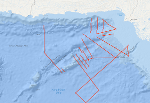
The Sonne Cruise SO122 was carried out by the Federal Institute for Geosciences and Natural Resources (BGR, Hannover) from 3rd August to 9th September 1997, in cooperation with GEOMAR (Kiel), the National Institute of Oceanography (NIO, Karachi) and the Hydrocarbon Development Institute of Pakistan (HDIP). During the joint project with R/V SONNE the Makran accretionary wedge off Pakistan should have been investigated in detail with multi-channel reflection seismics, magnetics and gravimetry. Intense fishery offshore Pakistan forced a change of the area of investigation to the south with the following objectives: investigation of the crustal structure and occurrence of the bottom simulating reflector (BSR) in the Makran accretionary wedge; investigation of the structure of the Murray Ridge System in order to reconstruct the geodynamic evolution of the eastern Indian Plate margin; determination of the origin of the crust underlying the Indus Fan and reconnaissance of the sedimentary history of the Indus Fan in order to reveal the uplift and erosion history of the Himalayas. Die SONNE-Fahrt SO122 fand unter Federführung der BGR vom 3. August bis zum 6. September 1997 statt. BGR, GEOMAR, das National Institute of Oceanography (NIO, Karachi) und das Hydrocarbon Development Institute of Pakistan (HDIP) wollten in einem gemeinsamen Projekt den Makran-Akkretionskeil reflexionsseismisch, gravimetrisch und magnetisch untersuchen. Intensive Fischerei in den Gebieten vor der pakistanischen Küste zwang zur Verlagerung des Arbeitsgebietes nach Süden unter folgender Zielsetzung: Untersuchung der Krustenstruktur und der Verbreitung von Meeresboden simulierenden Reflektoren (BSR) an der Basis von Gashydraten im Makran-Akkretionskeil; Untersuchung der Strukturmerkmale des Murray-Rücken-Systems zur Rekonstruktion der geodynamischen Geschichte des östlichen indischen Plattenrandes; Bestimmung der Krustenstruktur unter dem Indus-Fächer sowie der Bestimmung der Sedimentationsgeschichte im Indus-Fächer als Hinweis zur geologisch-tektonischen Geschichte des Himalayas.
Raumbezug
Lage der Geodaten (in WGS84)
| SW Länge/Breite | NO Länge/Breite | |
|---|---|---|
| 62.354°/20.407° | 66.935°/25.044° |
| Koordinatensystem |
|---|
Verweise und Downloads
Weitere Verweise (26)
| Identifikator des übergeordneten Metadatensatzes |
06a73c56-06a2-40d8-b806-466222b0760d |
|---|
Nutzung
| Nutzungsbedingungen |
Allgemeine Geschäftsbedingungen, siehe http://www.bgr.bund.de/AGB - General terms and conditions, see http://www.bgr.bund.de/AGB_en. Die bereitgestellten Informationen sind bei Weiterverwendung wie folgt zu zitieren: Datenquelle: SO122 1997, (c) BGR, Hannover, 1997 |
|---|
| Zugriffsbeschränkungen |
no limitations to public access |
|---|
Kontakt
Fachinformationen
Informationen zum Datensatz
| Identifikator |
59e92fcc-a286-f3d8-baa1-ba4abfaf2a0f |
|---|
| Digitale Repräsentation |
Vector |
|---|
| Fachliche Grundlage |
During the period from 3rd August to 6th September 1997 BGR acquired seismic lines off Pakistan. The lines SO122-03, SO122-04, SO122-04A, SO122-08, SO122-09, SO122-10, SO122-11, SO122-12, SO122-13, SO122-13A, SO122-14, SO122-15, SO122-16, SO122-17, SO122-18, SO122-19, SO122-19A, SO122-19B, SO122-21, SO122-22, SO122-23, SO122-24, SO122-25, SO122-26, SO122-27 are processed (migrated) data. |
|---|
Zusatzinformationen
| Sprache des Datensatzes |
Englisch |
|---|
Konformität
| Spezifikation der Konformität | Spezifikationsdatum | Grad der Konformität | Geprüft mit |
|---|---|---|---|
| VERORDNUNG (EG) Nr. 1089/2010 DER KOMMISSION vom 23. November 2010 zur Durchführung der Richtlinie 2007/2/EG des Europäischen Parlaments und des Rates hinsichtlich der Interoperabilität von Geodatensätzen und -diensten | 08.12.2010 | siehe dazu die angegebene Durchführungsbestimmung |
Datenformat
| Name | Version | Kompressionstechnik | Spezifikation |
|---|---|---|---|
| Shapefile | n/a |
Schlagworte
| INSPIRE-Themen | Geology |
| GEMET-Concepts | geophysics Geophysik raw material Rohstoff |
| ISO-Themenkategorien | Geoscientific Information |
| Suchbegriffe | Arabian Sea Indian Ocean Marine geology Meeresgeologie Pakistan Seismics Seismik Two-dimensional seismic reflection zweidimensionale Reflektionsseismik |
Informationen zum Metadatensatz
| Objekt-ID |
954e6fb9-99f3-455a-8e04-9205843f2fa8 |
|---|
| Aktualität der Metadaten |
16.11.2023 |
|---|
| Sprache Metadatensatz |
Englisch |
|---|
| Datensatz / Datenserie |
Dataset |
|---|
| XML Darstellung |
|---|
| Point of Contact (Metadatum) |
|---|
| Metadatenquelle |
GeoDaK (Datenkatalog der Bundesanstalt für Geowissenschaften und Rohstoffe)
|
|---|---|
|
Bundesanstalt für Geowissenschaften und Rohstoffe
|


