Suche Karten Messwerte Kataloge Über NUMIS Anbieter Datenquellen API
Hilfe Kontakt Inhalt Impressum Datenschutz Barrierefreiheit
NUMIS - Das niedersächsische Umweltportal NUMIS - Das niedersächsische Umweltportal
Suche
Karten
Messwerte
Kataloge
API
Alle Suchergebnisse
Geodatensatz

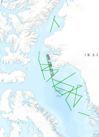
Processed seismic data of Cruise ARK25/3

Inhalt
  • Übersicht
  • Be­schrei­bung
    Aktualität des Datensatzes
  • Raumbezug
  • Verweise und Downloads
    Downloads Weitere Verweise
  • Nutzung
  • Kontakt
    Point of Contact
  • Fach­informationen
    Informationen zum Datensatz Zusatzinformationen Schlag­worte
  • Metadatensatz

Downloads (1)

ARK25/3 2010 (Shapefile) ARK25/3 2010 im Format ESRI Shape [2.0 MB]

Nutzungs­bedingun­gen

Allgemeine Geschäftsbedingungen, siehe https://www.bgr.bund.de/AGB - General terms and conditions, see https://www.bgr.bund.de/AGB_en. Die bereitgestellten Informationen sind bei Weiterverwendung wie folgt zu zitieren: Datenquelle: ARK25/3, (c) BGR, Hannover, 2010

Point of Contact

Federal Institute for Geosciences and Natural Resources

Marine_Seismik@bgr.de

Vorschau

img

Be­schrei­bung

ARK25/3 2010

The multidisciplinary marine geoscientific expedition ARK-25/3 was focused on the Greenland part of northern Baffin Bay and was aimed to acquire new geoscientific data to be used for modelling the evolution of the Greenland continental margin and its hydrocarbon prospective. The data format is Society of Exploration Geophysicists SEG Y. The cruise was performed under the direction of the Federal Institute for Geosciences and Natural Resources Hannover in cooperation with the Alfred-Wegener-Institute for Polar and Marine Research, Bremerhaven. Using 70 days of ship time onboard the research icebreaker R/V POLARSTERN a comprehensive data set was acquired along profiles extending from the deep oceanic basin in the central part of North Baffin Bay onto the Greenland continental margin in an area which was bordered by the Kane Basin in the North and Disko Island in the South. By means of multi-channel seismic, wide angle seismic, gravimetric and magnetic methods the structural inventory of the crust in the NW Baffin Bay was investigated. Additionally, heat flow data and sediment cores were collected along lines crossing the Greenland continental margin. The cores were extracted for geochemical and geomicrobiological analysis to be used for basin modelling, studying the hydrocarbon potential, and the hydrocarbon degradation by microorganisms under polar conditions. Geological sampling in the coastal area was done between Melville Bay and Washington Land. The collected rock material will be used to derive constraints on the erosion history of the coastal area. Aeromagnetic data was acquired covering a substantial part of the marine survey area to investigate magnetic signatures of the oceanic crust and the continental margin. This report summarizes the working programme and contains the documentation of acquired data and first results of the expedition. Die Forschungsfahrt ARK-25/3 führte in den grönländischen Teil der nördlichen Baffinbay. Schwerpunkt des wissenschaftlichen Programms bildeten multidisziplinäre marine Forschungs-arbeiten zur Klärung der tektonischen Entwicklung des grönländischen Teils der Baffinbay und der Abschätzung seines Kohlenwasserstoffpotentials. Die Daten liegen im Format der Society of Exploration Geophysicists SEG Y vor.Das Projekt wurde unter Federführung der Bundesanstalt für Geowissenschaften und Rohstoffe Hannover in Kooperation mit dem Alfred-Wegener-Institut Bremerhaven durchgeführt. Während der 70-tägigen Forschungsfahrt an Bord des F/S POLARSTERN wurde ein umfangreicher Datensatz entlang von Messprofilen akquiriert, die den Bereich vom Zentralteil der nördlichen Baffinbay bis auf den grönländischen Kontinentrand und von Disko Island im Süden bis zum Kane Basin im Norden abdecken. Mit Hilfe von Mehrkanalseismik, Weitwinkelseismik, gravimetrischen und magnetischen Messverfahren wurde das strukturelle Inventar der Kruste in der nordwestlichen Baffinbay untersucht. Zusätzlich wurden an mehr als 30 ausgewählten Lokationen entlang von Profilen über den grönländischen Kontinentrand Wärmestrommessungen vorgenommen und Sedimentkerne entnommen. Das Probenmaterial wird nachfolgend geochemisch und geomikrobiologisch analysiert. Die Ergebnisse fließen in Modellierungen der Beckenbildungsprozesse ein und werden für die Bewertung des Kohlenwasserstoffpotentials der Region und der Kohlenwasserstoffzersetzung durch Mikroorganismen unter polaren Bedingungen verwendet. Geologische Beprobungen von Aufschlüssen der küstennahen Region zwischen Melville Bay und Washington Land wurden vorgenommen, um die Erosionsgeschichte des grönländischen Kontinentrandes zu rekonstruieren. Aeromagnetische Befliegungen in weiten Teilen des Arbeitsgebietes flankierten das marine Arbeitsprogramm zur Untersuchung magnetischer Signaturen der ozeanischen Kruste und des grönländischen Kontinentrandes. Im vorliegenden Bericht werden Arbeitsprogramm und erste Ergebnisse der Forschungsfahrt dokumentiert.

Aktualität des Datensatzes

Creation

27.09.2010

Status

completed

Raumbezug

Lage der Geodaten (in WGS84)
SW Länge/Breite NO Länge/Breite
-74.831°/70.687° -54.839°/80.167°
Koordinaten­system
EPSG:4326

Verweise und Downloads

Downloads (1)

ARK25/3 2010 (Shapefile) ARK25/3 2010 im Format ESRI Shape [2.0 MB]

Weitere Verweise (27)

http://www.geo-seas.eu/v_cdi_v3/print_ajax.asp?n_code=1248509 Information Profil BGR10-302A
http://www.geo-seas.eu/v_cdi_v3/print_ajax.asp?n_code=1248510 Information Profil BGR10-302
http://www.geo-seas.eu/v_cdi_v3/print_ajax.asp?n_code=1248511 Information Profil BGR10-303A
http://www.geo-seas.eu/v_cdi_v3/print_ajax.asp?n_code=1248512 Information Profil BGR10-305A
http://www.geo-seas.eu/v_cdi_v3/print_ajax.asp?n_code=1248513 Information Profil BGR10-305
http://www.geo-seas.eu/v_cdi_v3/print_ajax.asp?n_code=1248514 Information Profil BGR10-306A
http://www.geo-seas.eu/v_cdi_v3/print_ajax.asp?n_code=1248515 Information Profil BGR10-306
http://www.geo-seas.eu/v_cdi_v3/print_ajax.asp?n_code=1248516 Information Profil BGR10-307A
http://www.geo-seas.eu/v_cdi_v3/print_ajax.asp?n_code=1248517 Information Profil BGR10-307
http://www.geo-seas.eu/v_cdi_v3/print_ajax.asp?n_code=1248518 Information Profil BGR10-308A
http://www.geo-seas.eu/v_cdi_v3/print_ajax.asp?n_code=1248519 Information Profil BGR10-308
http://www.geo-seas.eu/v_cdi_v3/print_ajax.asp?n_code=1248520 Information Profil BGR10-309
http://www.geo-seas.eu/v_cdi_v3/print_ajax.asp?n_code=1248521 Information Profil BGR10-310
http://www.geo-seas.eu/v_cdi_v3/print_ajax.asp?n_code=1248522 Information Profil BGR10-311
http://www.geo-seas.eu/v_cdi_v3/print_ajax.asp?n_code=1248523 Information Profil BGR10-312
http://www.geo-seas.eu/v_cdi_v3/print_ajax.asp?n_code=1248524 Information Profil BGR10-313
http://www.geo-seas.eu/v_cdi_v3/print_ajax.asp?n_code=1248525 Information Profil BGR10-314
http://www.geo-seas.eu/v_cdi_v3/print_ajax.asp?n_code=1248526 Information Profil BGR10-318A
http://www.geo-seas.eu/v_cdi_v3/print_ajax.asp?n_code=1248527 Information Profil BGR10-318
http://www.geo-seas.eu/v_cdi_v3/print_ajax.asp?n_code=1248528 Information Profil BGR10-319
http://www.geo-seas.eu/v_cdi_v3/print_ajax.asp?n_code=1248529 Information Profil BGR10-320
http://www.geo-seas.eu/v_cdi_v3/print_ajax.asp?n_code=1248530 Information Profil BGR10-321
http://www.geo-seas.eu/v_cdi_v3/print_ajax.asp?n_code=1248531 Information Profil BGR10-322
https://download.bgr.de/bgr/marineseismik/info/message_na.html Information Profil BGR10-315
https://download.bgr.de/bgr/marineseismik/info/message_na.html Information Profil BGR10-316
https://download.bgr.de/bgr/marineseismik/info/message_na.html Information Profil BGR10-317
https://services.bgr.de/geophysik/mssp Information Karte im BGR-Geoviewer
Identifikator des über­geordneten Metadaten­satzes

06a73c56-06a2-40d8-b806-466222b0760d

Nutzung

Nutzungs­bedingun­gen

Allgemeine Geschäftsbedingungen, siehe https://www.bgr.bund.de/AGB - General terms and conditions, see https://www.bgr.bund.de/AGB_en. Die bereitgestellten Informationen sind bei Weiterverwendung wie folgt zu zitieren: Datenquelle: ARK25/3, (c) BGR, Hannover, 2010

Zugriffs­beschränkun­gen

no limitations to public access

Kontakt

Point of Contact

Federal Institute for Geosciences and Natural Resources

Stilleweg 2
30655 Hannover

Marine_Seismik@bgr.de

Fach­informationen

Informationen zum Datensatz

Identifikator

61c769ed-af0a-4875-83bc-6907b23822f6

Digitale Repräsentation

Vector

Fachliche Grundlage

During the period of 1st of August to 9th of October 2010 BGR aquired seismic lines in the Baffin Bay. The lines BGR10-302, BGR10-302A, BGR10-303A, BGR10-305, BGR10-305A, BGR10-306, BGR10-306A, BGR10-307, BGR10-307A, BGR10-308, BGR10-308A, BGR10-309, BGR10-310, BGR10-311, BGR10-312, BGR10-313, BGR10-314, BGR10-315, BGR10-316, BGR10-317, BGR10-318 BGR10-318A, BGR10-319, BGR10-320, BGR10-321, BGR10-322 are processed (migrated) data.

Zusatzinformationen

Sprache des Daten­satzes

Englisch

Kon­formi­tät
Spezifi­kation der Kon­formi­tät Spezifi­kations­datum Grad der Kon­formi­tät Geprüft mit
VERORDNUNG (EG) Nr. 1089/2010 DER KOMMISSION vom 23. November 2010 zur Durchführung der Richtlinie 2007/2/EG des Europäischen Parlaments und des Rates hinsichtlich der Interoperabilität von Geodatensätzen und -diensten 08.12.2010 siehe dazu die angegebene Durchführungsbestimmung
Datenformat
Name Version Kompressionstechnik Spezifi­kation
Shapefile n/a

Schlag­worte

INSPIRE-Themen Geology
GEMET-Concepts geophysics Geophysik raw material Rohstoff seismics Seismik
ISO-Themen­kategorien Geoscientific Information
Suchbegriffe Baffin Bay Baffinbucht marine geology Meeresgeologie MSSP two-dimensional seismic reflection zweidimensionale Reflektionsseismik

Informationen zum Metadatensatz

Objekt-ID

bc2481a7-bac2-4fab-bb32-9ef26854a04e

Aktualität der Metadaten

07.04.2025

Sprache Metadatensatz

Englisch

Datensatz / Datenserie  

Dataset

XML Dar­stellung
Metadaten als XML herunter­laden
Point of Contact (Metadatum)
geodatenmanagement@bgr.de
Metadatenquelle
GeoDaK (Datenkatalog der Bundesanstalt für Geowissenschaften und Rohstoffe)
Bundesanstalt für Geowissenschaften und Rohstoffe

NUMIS - Das niedersächsische Umweltportal
Niedersächsisches Ministerium für Umwelt,
Energie und Klimaschutz
Hilfe Kontakt Inhalt Impressum Datenschutz Barrierefreiheit
Nach oben

Hilfe

NUMIS NUMIS
UVP UVP