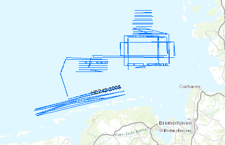
The previous BGR-cruises with RV AURELIA in 2003 and 2004 were designed to collect a grid of seismic MCS-data which should enable us to get a high-resolution overview over the upper 1 s TWT of the sediments of the German North Sea sector. The data format is Society of Exploration Geophysicists SEG Y. Together with the previously acquired data these new data should help to extend our knowledge of the Late Tertiary and Quaternary evolution of the German North Sea Sector. For the current measurements under the scope of the DFG-funded project RE2424/1-1 ‚Nordsee’ the research vessel RV HEINCKE was made available by the ‘Senatskommission für Ozeanographie’ of the DFG. During the cruise a total ca. 1400 km of high quality MCS lines were surveyed and simultaneously measured by a sediment echosounder system that enabled additional profiles during transits with speeds > 5 kn. The BGR high-resolution multichannel seismic reflection system consisting of a GI-Gun (0.8 l) and a 300 m streamer with 24 channels and a sediment echosounder type SES 2000 standard by Innomar, Rostock. While the BGR-seismic system was used to observe the shallow subsurface down to 2 s TWT penetration depth, the sediment echosounder with a penetration depth of several meters was primarily intended to identify sampling positions for the deployment of the BGR vibration corer during the succeeding Leg 2. Additionally, the echosounder system enables the relationship to the highest-resolution multichannel seismic measurements of the group of the University of Bremen on FK SENCKENBERG. All seismic records were processed onboard for the quality control and for a first interpretation. Im Gegensatz zu den beiden vorangegangen BGR-Fahrten mit FS AURELIA in 2003 und 2004, die Übersichtsvermessungen dienten, waren die Ziele dieser Fahrt kleinräumige Spezial-vermessungen, die der Beantwortung spezieller wissenschaftlicher Fragestellungen dienen sollen, die auf Grund der vorhanden Daten formuliert worden sind. Die Daten liegen im Format der Society of Exploration Geophysicists SEG Y vor. Es sollte die spättertiäre und quartäre Entwicklung des deutschen Nordsee-Sektors aufbauend auf den Ergebnissen der vorangegangenen Expeditionen weiter systematisch erkundet werden. Für die Vermessungen im Rahmen des DFG-Projektes RE2424/1-1 ‚Nordsee’ wurde das Forschungsschiff FS HEINCKE seitens der Senatskommission für Ozeanographie der DFG zur Verfügung gestellt. Während der Fahrt wurden insgesamt ca. 1400 km qualitativ hochwertiger MCS-Daten erfasst und gleichzeitig mit einem Sedimentecholot vermessen, das zusätzlich während auf den Transitstrecken (Geschwindigkeit > 5kn) lieferte. Eingesetzt wurde das BGR-eigene hochauflösende System, bestehend aus einer GI-Gun (0.8 l) und einem 300 m langen Streamer mit 24 Kanälen und ein Sedimentecholot Typ SES 2000 standard der Fa. Innomar, Rostock. Während das BGR-System zur regelmäßigen Erfassung des gesamten flachen Oberbaus bis 2 s TWT Eindringtiefe eingesetzt wurde, sollte das Sedimentecholot mit einer Eindringung von mehreren Metern vor allem zur Lokalisation von Beprobungspunkten für den Einsatz des BGR Vibrationskerngeräts im anschließenden Leg 2 dienen, aber auch eine Verbindung zu den höchstauflösenden Mehrkanalseismik-Messungen der Bremer Gruppe auf FK SENCKENBERG bilden. Alle seismischen Profile wurden zur Qualitätskontrolle und für eine erste Auswertung prozessiert.
Raumbezug
Lage der Geodaten (in WGS84)
| SW Länge/Breite | NO Länge/Breite | |
|---|---|---|
| 6.368°/53.634° | 8.341°/54.506° |
| Koordinatensystem |
|---|
Verweise und Downloads
Weitere Verweise (49)
| Identifikator des übergeordneten Metadatensatzes |
06a73c56-06a2-40d8-b806-466222b0760d |
|---|
Nutzung
| Nutzungsbedingungen |
Allgemeine Geschäftsbedingungen, siehe https://www.bgr.bund.de/AGB - General terms and conditions, see https://www.bgr.bund.de/AGB_en. Die bereitgestellten Informationen sind bei Weiterverwendung wie folgt zu zitieren: Datenquelle: HE242, (c) BGR, Hannover, 2005 |
|---|
| Zugriffsbeschränkungen |
no limitations to public access |
|---|
Kontakt
Fachinformationen
Informationen zum Datensatz
| Identifikator |
cf3445a1-1ddf-4655-a2eb-020b8247dcbd |
|---|
| Digitale Repräsentation |
Vector |
|---|
| Fachliche Grundlage |
During the period from 17th of October to 14th of November 2005 BGR aquired seismic lines in the Central North Sea. The lines HE242-01, HE242-02, HE242-03, HE242-04, HE242-04A, HE242-05, HE242-06, HE242-07, HE242-07A, HE242-08, HE242-09, HE242-10, HE242-11, HE242-12, HE242-13, HE242-14, HE242-15, HE242-16, HE242-17, HE242-18, HE242-19, HE242-20, HE242-21, HE242-22, HE242-23, HE242-24, HE242-25, HE242-26, HE242-27, HE242-27A, HE242-30, HE242-31, HE242-32, HE242-33, HE242-34, HE242-35, HE242-36, HE242-37, HE242-40, HE242-41 and HE242-44 are processed (stack) data, whereas lines HE242-28, HE242-29, HE242-32A, HE242-38, HE242-39, HE242-42, HE242-43 are raw data. |
|---|
Zusatzinformationen
| Sprache des Datensatzes |
Englisch |
|---|
Konformität
| Spezifikation der Konformität | Spezifikationsdatum | Grad der Konformität | Geprüft mit |
|---|---|---|---|
| VERORDNUNG (EG) Nr. 1089/2010 DER KOMMISSION vom 23. November 2010 zur Durchführung der Richtlinie 2007/2/EG des Europäischen Parlaments und des Rates hinsichtlich der Interoperabilität von Geodatensätzen und -diensten | 08.12.2010 | siehe dazu die angegebene Durchführungsbestimmung |
Datenformat
| Name | Version | Kompressionstechnik | Spezifikation |
|---|---|---|---|
| Shapefile | n/a |
Schlagworte
| INSPIRE-Themen | Geology |
| GEMET-Concepts | geophysics Geophysik marine geology Meeresgeologie raw material Rohstoff |
| ISO-Themenkategorien | Geoscientific Information |
| Suchbegriffe | Deutsche AWZ GeolDG German EEZ MSSP Nordsee North Sea seismics Seismik two-dimensional seismic reflection zweidimensionale Reflektionsseismik |
Informationen zum Metadatensatz
| Objekt-ID |
a3f2f6a5-120c-4732-97a0-1db01f26557d |
|---|
| Aktualität der Metadaten |
07.04.2025 |
|---|
| Sprache Metadatensatz |
Englisch |
|---|
| Datensatz / Datenserie |
Dataset |
|---|
| XML Darstellung |
|---|
| Point of Contact (Metadatum) |
|---|
| Metadatenquelle |
GeoDaK (Datenkatalog der Bundesanstalt für Geowissenschaften und Rohstoffe)
|
|---|---|
|
Bundesanstalt für Geowissenschaften und Rohstoffe
|


