Suche Karten Messwerte Kataloge Über NUMIS Anbieter Datenquellen API
Hilfe Kontakt Inhalt Impressum Datenschutz Barrierefreiheit
NUMIS - Das niedersächsische Umweltportal NUMIS - Das niedersächsische Umweltportal
Suche
Karten
Messwerte
Kataloge
API
Alle Suchergebnisse
Geodatensatz

Processed seismic data of Cruise BGR78-2 1978

Inhalt
  • Übersicht
  • Be­schrei­bung
    Aktualität des Datensatzes
  • Raumbezug
  • Verweise und Downloads
    Downloads Weitere Verweise
  • Nutzung
  • Kontakt
    Point of Contact
  • Fach­informationen
    Informationen zum Datensatz Zusatzinformationen Schlag­worte
  • Metadatensatz

Downloads (1)

BGR78-2 1978 (Shapefile) BGR78-2 1978 im Format ESRI Shape [1.0 MB]

Nutzungs­bedingun­gen

Allgemeine Geschäftsbedingungen, siehe http://www.bgr.bund.de/AGB - General terms and conditions, see http://www.bgr.bund.de/AGB_en. Die bereitgestellten Informationen sind bei Weiterverwendung wie folgt zu zitieren: Datenquelle: BGR78-2 1978, (c) BGR, Hannover, 2019

Point of Contact

Federal Institute for Geosciences and Natural Resources

Marine_Seismik@bgr.de

Vorschau

img

Be­schrei­bung

BGR78-2 1978

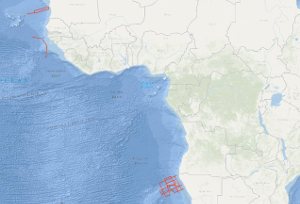
During the second leg of cruise BGR78 from 22th of February to 29th of March 1978 with R/V EXPLORA the following measurements have been carried out as presite- and postsite surveys of DSDP sites: (1) in the region of the eastern Walvis Ridge 4,350 km multichannel seismic reflection profiles, 4,540 km magnetic measurements, 5,000 km gravimetric measurements and sonobuoy refraction measurements on 11 stations (2) on the Guinea Plateau 740 km multichannel seismic reflection profiles in parallel with gravimetric and magnetic measurements (3) between Cape Verde islands and Mauretania 980 km multichannel seismic reflection profiles in parallel with magnetic measurements, 1,480 km gravimetric measurements and sonobuoy refraction measurements on 2 stations. The geophysical measurements show that the structure of the Walvis Ridge is determined by two main tectonic directions (WSW-ENE and SSW-NNE). Presumably the genesis of the fracture zone in the Walvis Ridge area can be traced back to the sea-floor spreading with overprinting effects due to an inhomogeneity in the mantle ("hot spot"). Both DSDP drilling projects in this part of the Walvis Ridge led to a fragmentary knowledge because site 362 got stuck at a depth of 1.100 m in the Oligocene. BGR's measurements indicate a gap of at least 1.000 m of sediments, especially from the cretaceous period, down to the (acoustic) basement. Site 363 at a submarine high has gaps in the depositional sequence and stops at a depth of 700 m shortly above the basement. So for a better understanding of the geologic development of the Walvis Ridge, further DSDP drillings with a recovery of the complete sedimentary sequence and the following basement cores are necessary. Therefore BGR's measurements of this cruise propose new DSDP sites. In der Zeit vom 22. Februar bis zum 29. März 1978 sind auf dem zweiten Abschnitt der Fahrt BGR78 mit R/V EXPLORA folgende Messungen als presite- und postsite-surveys von DSDP-Bohrungen ausgeführt worden: (1) im Bereich des östlichen Walvis-Ridge 4.350 Profilkilometer Mehrspurseismik, 4.540 Profilkilometer Magnetik, 5.000 Profilkilometer Gravimetrie sowie refraktionsseismische Messungen auf 11 Stationen mit Sonobojen (2) auf dem Guinea-Plateau 740 km Mehrspurseismik, Magnetik und Gravimetrie sowie 1 Sonoboje, (3) zwischen den Kapverden und Mauretanien 980 km Mehrspurseismik und Magnetik, 1.480 km Gravimetrie sowie 2 Sonobojen. Nach den Ergebnissen der Erstauswertung an Bord von R/V EXPLORA kann der Walvis-Ridge als eine Struktur angesehen werden, die in ihrer Ausbildung von zwei tektonischen Richtungen (WSW-ENE und SSW-NNE) bestimmt wird. Das deutet auf eine Entstehung als Bruchzone nach der Theorie des sea-floor-spreading hin, die von einer Inhomogenität im Erdmantel ("hot spot") überprägt worden ist. Die beiden DSDP-Bohrungen in diesem Teil des Walvis-Ridge sind unvollständig. Site 362 in einem Sedimentbecken ist mit 1100 m Endteufe im Oligozän steckengeblieben. Nach den BGR-Messungen fehlen noch mindestens 1000 m Sedimente (darunter solche aus der Kreide) bis zum (akustischen) Basement. Site 363 an einer submarinen Erhöhung weist Schichtlücken im Sedimentprofil auf und geht mit 700 m Endteufe bis dicht an das Basement. Zur Klärung der Entstehungsgeschichte des Walvis-Ridge werden aufgrund der BGR-Messungen Lokationen für weitere DSDP-Bohrungen zur Gewinnung einer Basementfolge und zur Gewinnung eines vollständigen Sedimentprofils vorgeschlagen.

Aktualität des Datensatzes

Creation

29.03.1978

Status

completed

Raumbezug

Lage der Geodaten (in WGS84)
SW Länge/Breite NO Länge/Breite
-21.388°/-22.151° 12.704°/19.107°
Koordinaten­system
EPSG:4326

Verweise und Downloads

Downloads (1)

BGR78-2 1978 (Shapefile) BGR78-2 1978 im Format ESRI Shape [1.0 MB]

Weitere Verweise (20)

http://www.geo-seas.eu/v_cdi_v3/print_ajax.asp?n_code=1507134 Information Profile BGR78-128
http://www.geo-seas.eu/v_cdi_v3/print_ajax.asp?n_code=1507135 Information Profile BGR78-129
http://www.geo-seas.eu/v_cdi_v3/print_ajax.asp?n_code=1507136 Information Profile BGR78-130
http://www.geo-seas.eu/v_cdi_v3/print_ajax.asp?n_code=1507137 Information Profile BGR78-131
http://www.geo-seas.eu/v_cdi_v3/print_ajax.asp?n_code=1507138 Information Profile BGR78-132
http://www.geo-seas.eu/v_cdi_v3/print_ajax.asp?n_code=1507139 Information Profile BGR78-133
http://www.geo-seas.eu/v_cdi_v3/print_ajax.asp?n_code=1507140 Information Profile BGR78-134A
http://www.geo-seas.eu/v_cdi_v3/print_ajax.asp?n_code=1507141 Information Profile BGR78-134
http://www.geo-seas.eu/v_cdi_v3/print_ajax.asp?n_code=1507142 Information Profile BGR78-135
http://www.geo-seas.eu/v_cdi_v3/print_ajax.asp?n_code=1507143 Information Profile BGR78-136
http://www.geo-seas.eu/v_cdi_v3/print_ajax.asp?n_code=1507144 Information Profile BGR78-138
http://www.geo-seas.eu/v_cdi_v3/print_ajax.asp?n_code=1507145 Information Profile BGR78-139
http://www.geo-seas.eu/v_cdi_v3/print_ajax.asp?n_code=1507146 Information Profile BGR78-140
http://www.geo-seas.eu/v_cdi_v3/print_ajax.asp?n_code=1507147 Information Profile BGR78-141
http://www.geo-seas.eu/v_cdi_v3/print_ajax.asp?n_code=1507148 Information Profile BGR78-145
http://www.geo-seas.eu/v_cdi_v3/print_ajax.asp?n_code=1507149 Information Profile BGR78-146
http://www.geo-seas.eu/v_cdi_v3/print_ajax.asp?n_code=1507150 Information Profile BGR78-149
http://www.geo-seas.eu/v_cdi_v3/print_ajax.asp?n_code=1507151 Information Profile BGR78-150
http://www.geo-seas.eu/v_cdi_v3/print_ajax.asp?n_code=1507152 Information Profile BGR78-151
https://services.bgr.de/geophysik/mssp Information Karte im BGR-Geoviewer
Identifikator des über­geordneten Metadaten­satzes

06a73c56-06a2-40d8-b806-466222b0760d

Nutzung

Nutzungs­bedingun­gen

Allgemeine Geschäftsbedingungen, siehe http://www.bgr.bund.de/AGB - General terms and conditions, see http://www.bgr.bund.de/AGB_en. Die bereitgestellten Informationen sind bei Weiterverwendung wie folgt zu zitieren: Datenquelle: BGR78-2 1978, (c) BGR, Hannover, 2019

Zugriffs­beschränkun­gen

no limitations to public access

Kontakt

Point of Contact

Federal Institute for Geosciences and Natural Resources

Stilleweg 2
30655 Hannover

Marine_Seismik@bgr.de

Fach­informationen

Informationen zum Datensatz

Identifikator

d0582412-d868-16e2-9833-167140819201

Digitale Repräsentation

Vector

Fachliche Grundlage

During the period from 22th February to 29th March 1978 BGR acquired seismic lines in the Southeast Atlantic Ocean across the Walvis Ridge and the Guinea Plateau and off Mauretania during the second leg of cruise BGR78. The lines BGR78-127, BGR78-137 and BGR78-148 consist of raw data. The lines BGR78-128, BGR78-129, BGR78-130, BGR78-131, BGR78-132, BGR78-133, BGR78-134, BGR78-134A, BGR78-135, BGR78-136, BGR78-138, BGR78-139, BGR78-140, BGR78-141, BGR78-145, BGR78-146, BGR78-149, BGR78-150 and BGR78-151 are stacked data.

Zusatzinformationen

Sprache des Daten­satzes

Englisch

Kon­formi­tät
Spezifi­kation der Kon­formi­tät Spezifi­kations­datum Grad der Kon­formi­tät Geprüft mit
VERORDNUNG (EG) Nr. 1089/2010 DER KOMMISSION vom 23. November 2010 zur Durchführung der Richtlinie 2007/2/EG des Europäischen Parlaments und des Rates hinsichtlich der Interoperabilität von Geodatensätzen und -diensten 08.12.2010 siehe dazu die angegebene Durchführungsbestimmung
Datenformat
Name Version Kompressionstechnik Spezifi­kation
Shapefile n/a

Schlag­worte

INSPIRE-Themen Geology
GEMET-Concepts geophysics Geophysik raw material Rohstoff
ISO-Themen­kategorien Geoscientific Information
Suchbegriffe Guinea Plateau Marine geology Mauretania Mauretanien Meeresgeologie Seismics Seismik Southeast Atlantic Ocean Südost-Atlantik Two-dimensional seismic reflection Walvis Ridge Walvis-Rücken zweidimensionale Reflektionsseismik

Informationen zum Metadatensatz

Objekt-ID

96dcdd10-3847-428b-bd2d-b4c93e169b21

Aktualität der Metadaten

14.11.2023

Sprache Metadatensatz

Englisch

Datensatz / Datenserie  

Dataset

XML Dar­stellung
Metadaten als XML herunter­laden
Point of Contact (Metadatum)
geodatenmanagement@bgr.de
Metadatenquelle
GeoDaK (Datenkatalog der Bundesanstalt für Geowissenschaften und Rohstoffe)
Bundesanstalt für Geowissenschaften und Rohstoffe

NUMIS - Das niedersächsische Umweltportal
Niedersächsisches Ministerium für Umwelt,
Energie und Klimaschutz
Hilfe Kontakt Inhalt Impressum Datenschutz Barrierefreiheit
Nach oben

Hilfe

NUMIS NUMIS
UVP UVP