Suche Karten Messwerte Kataloge Über NUMIS Anbieter Datenquellen API
Hilfe Kontakt Inhalt Impressum Datenschutz Barrierefreiheit
NUMIS - Das niedersächsische Umweltportal NUMIS - Das niedersächsische Umweltportal
Suche
Karten
Messwerte
Kataloge
API
Alle Suchergebnisse
Geodatensatz

Processed seismic data of Cruise ANT-IV/3 1986

Inhalt
  • Übersicht
  • Be­schrei­bung
    Aktualität des Datensatzes
  • Raumbezug
  • Verweise und Downloads
    Downloads Weitere Verweise
  • Nutzung
  • Kontakt
    Point of Contact
  • Fach­informationen
    Informationen zum Datensatz Zusatzinformationen Schlag­worte
  • Metadatensatz

Downloads (1)

ANT-IV/3 1986 (Shapefile) ANT-IV/3 1986 im Format ESRI Shape [2.0 MB]

Nutzungs­bedingun­gen

Allgemeine Geschäftsbedingungen, siehe http://www.bgr.bund.de/AGB - General terms and conditions, see http://www.bgr.bund.de/AGB_en. Die bereitgestellten Informationen sind bei Weiterverwendung wie folgt zu zitieren: Datenquelle: ANT-IV/3 1986, (c) BGR, Hannover, 2019

Point of Contact

Federal Institute for Geosciences and Natural Resources

Marine_Seismik@bgr.de

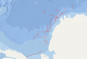
Vorschau

img

Be­schrei­bung

ANT-IV/3 1986

On the F.S. POLARSTERN cruise ANT-IV/3 (6th December, 1985 - 13th March, 1986) multichannel seismic measurements were carried out in parallel with magnetic and gravimetric measurements on 33 lines with a total length of 6,263 km. 3,350 km of the multichannel seismic lines have been processed aboard. The geophysical studies were designed to investigate the structure and geological development of the Weddell Sea continental margin from meridians zero to 60°W, and to define suitable and safe drilling locations for Leg 113 of the Ocean Drilling Program. The main results of the geophysical studies are: (1) The discovery of an approximately N50°E trending failed drift basin, following the trend of a negative magnetic anomaly and a positive gravity anomaly. (2) The discovery of two extensive wedge-shaped and symmetric basement units around a failed drift basin between longitudes 40°W and 20°W. The seismic characteristics, i.e. seismic velocities of 4 km/s and an internally divergent pattern of reflectors suggest that both wedges are formed from extrusive/intrusive volcanic rocks. (3) The confirmation of a major plate tectonic boundary trending approximately N80°E to N60°E, i.e. the EXPLORA-ANDENES escarpment. (4) The confirmation of a glaciogenic progradational wedge beneath the shelf of the Weddell Sea Embayment, made up of several thousand metres of sediments. (5) The definition of 13 suitable and safe drilling locations for ODP-Leg 113. Während der Antarktis-Fahrt ANT-IV/3 vom 6. Dezember 1985 bis zum 13. März 1986 mit dem F.S. POLARSTERN wurden auf 33 Profilen mit einer Gesamtlänge von 6.263 Kilometern reflexionsseismische, magnetische und gravimetrische Messungen durchgeführt. Davon wurden 3.350 km reflexionsseismische Messungen (MCS) schon an Bord prozessiert. Diese geophysikalischen Untersuchungen sollten neue Erkenntnisse über die Struktur und die geologische Entwicklung des Kontinentrandes in dem Weddell-Meer innerhalb eines Bereiches von 0° bis 60°W liefern. Weiterhin wurden geeignete und sichere Bohrlokationen für den Abschnitt 113 des Ocean Drilling Program gesucht. Die wesentlichen Ergebnisse aus der Analyse der geophysikalischen Messungen sind: (1) Die Entdeckung eines in nordöstlicher Richtung verlaufenden Beckens infolge eines Grabenbruchs, das durch eine negative magnetische Anomalie und durch eine positive Anomalie des Schwerefeldes gekennzeichnet ist. (2) Die Entdeckung von zwei ausgedehnten keilförmigen und symmetrischen Einheiten des Grundgebirges, die einen Grabenbruch zwischen 40°W und 20°W flankieren. Die seismischen Charakteristika mit Geschwindigkeiten von mehr als 4 km/s und einem divergenten Muster an Reflektoren lassen darauf schließen, dass beide Keile aus extrusivem oder intrusivem vulkanischen Material bestehen. (3) Die Bestätigung einer Plattengrenze, die in nordöstlicher Richtung verläuft. Es handelt sich dabei um die EXPLORA-ANDENES-Geländestufe. (4) Die Bestätigung eines glaziogenen Keils unter dem Schelf des Weddell-Meeres, der sich weiter vorschiebt und aus mehreren 1000m mächtigen Sedimenten besteht. (5) Die Festlegung von 13 geeigneten und sicheren Bohrlokationen für den Abschnitt 113 des ODP-Programmes.

Aktualität des Datensatzes

Creation

13.03.1986

Status

completed

Raumbezug

Lage der Geodaten (in WGS84)
SW Länge/Breite NO Länge/Breite
-60.749°/-77.376° 3.25°/-64.164°
Koordinaten­system
EPSG:4326

Verweise und Downloads

Downloads (1)

ANT-IV/3 1986 (Shapefile) ANT-IV/3 1986 im Format ESRI Shape [2.0 MB]

Weitere Verweise (32)

http://www.geo-seas.eu/v_cdi_v3/print_ajax.asp?n_code=1298951 Information Profile ANT4-01
http://www.geo-seas.eu/v_cdi_v3/print_ajax.asp?n_code=1298952 Information Profile ANT4-02
http://www.geo-seas.eu/v_cdi_v3/print_ajax.asp?n_code=1298953 Information Profile ANT4-03
http://www.geo-seas.eu/v_cdi_v3/print_ajax.asp?n_code=1298954 Information Profile ANT4-04
http://www.geo-seas.eu/v_cdi_v3/print_ajax.asp?n_code=1298955 Information Profile ANT4-05
http://www.geo-seas.eu/v_cdi_v3/print_ajax.asp?n_code=1298956 Information Profile ANT4-06
http://www.geo-seas.eu/v_cdi_v3/print_ajax.asp?n_code=1298957 Information Profile ANT4-07
http://www.geo-seas.eu/v_cdi_v3/print_ajax.asp?n_code=1298958 Information Profile ANT4-08
http://www.geo-seas.eu/v_cdi_v3/print_ajax.asp?n_code=1298959 Information Profile ANT4-09
http://www.geo-seas.eu/v_cdi_v3/print_ajax.asp?n_code=1298960 Information Profile ANT4-10
http://www.geo-seas.eu/v_cdi_v3/print_ajax.asp?n_code=1298961 Information Profile ANT4-11
http://www.geo-seas.eu/v_cdi_v3/print_ajax.asp?n_code=1298962 Information Profile ANT4-12
http://www.geo-seas.eu/v_cdi_v3/print_ajax.asp?n_code=1298963 Information Profile ANT4-13
http://www.geo-seas.eu/v_cdi_v3/print_ajax.asp?n_code=1298964 Information Profile ANT4-14
http://www.geo-seas.eu/v_cdi_v3/print_ajax.asp?n_code=1298965 Information Profile ANT4-15
http://www.geo-seas.eu/v_cdi_v3/print_ajax.asp?n_code=1298966 Information Profile ANT4-16
http://www.geo-seas.eu/v_cdi_v3/print_ajax.asp?n_code=1298967 Information Profile ANT4-17
http://www.geo-seas.eu/v_cdi_v3/print_ajax.asp?n_code=1298968 Information Profile ANT4-18
http://www.geo-seas.eu/v_cdi_v3/print_ajax.asp?n_code=1298969 Information Profile ANT4-19
http://www.geo-seas.eu/v_cdi_v3/print_ajax.asp?n_code=1298970 Information Profile ANT4-21
http://www.geo-seas.eu/v_cdi_v3/print_ajax.asp?n_code=1298971 Information Profile ANT4-22
http://www.geo-seas.eu/v_cdi_v3/print_ajax.asp?n_code=1298972 Information Profile ANT4-23
http://www.geo-seas.eu/v_cdi_v3/print_ajax.asp?n_code=1298973 Information Profile ANT4-25
http://www.geo-seas.eu/v_cdi_v3/print_ajax.asp?n_code=1298974 Information Profile ANT4-26
http://www.geo-seas.eu/v_cdi_v3/print_ajax.asp?n_code=1298975 Information Profile ANT4-27
http://www.geo-seas.eu/v_cdi_v3/print_ajax.asp?n_code=1298976 Information Profile ANT4-28
http://www.geo-seas.eu/v_cdi_v3/print_ajax.asp?n_code=1298977 Information Profile ANT4-29
http://www.geo-seas.eu/v_cdi_v3/print_ajax.asp?n_code=1298978 Information Profile ANT4-30
http://www.geo-seas.eu/v_cdi_v3/print_ajax.asp?n_code=1298979 Information Profile ANT4-31
http://www.geo-seas.eu/v_cdi_v3/print_ajax.asp?n_code=1298980 Information Profile ANT4-32
http://www.geo-seas.eu/v_cdi_v3/print_ajax.asp?n_code=1298981 Information Profile ANT4-33
https://services.bgr.de/geophysik/mssp Information Karte im BGR-Geoviewer
Identifikator des über­geordneten Metadaten­satzes

06a73c56-06a2-40d8-b806-466222b0760d

Nutzung

Nutzungs­bedingun­gen

Allgemeine Geschäftsbedingungen, siehe http://www.bgr.bund.de/AGB - General terms and conditions, see http://www.bgr.bund.de/AGB_en. Die bereitgestellten Informationen sind bei Weiterverwendung wie folgt zu zitieren: Datenquelle: ANT-IV/3 1986, (c) BGR, Hannover, 2019

Zugriffs­beschränkun­gen

no limitations to public access

Kontakt

Point of Contact

Federal Institute for Geosciences and Natural Resources

Stilleweg 2
30655 Hannover

Marine_Seismik@bgr.de

Fach­informationen

Informationen zum Datensatz

Identifikator

1692894b-6270-2a57-cccb-13a301e91531

Digitale Repräsentation

Vector

Fachliche Grundlage

During the period from 6th December 1985 to 13th March 1986 BGR acquired seismic lines in the Weddell Sea. The lines ANT4-11A, ANT4-20 and ANT4-24 consist of raw data. The lines ANT4-10, ANT4-11, ANT4-16, ANT4-23, ANT4-26 and ANT4-30 are stacked data. The lines ANT4-01, ANT4-02, ANT4-03, ANT4-04, ANT4-05, ANT4-06, ANT4-07, ANT4-08, ANT4-09, ANT4-12, ANT4-13, ANT4-14, ANT4-15, ANT4-17, ANT4-18, ANT4-19, ANT4-21, ANT4-22, ANT4-25, ANT4-27, ANT4-28, ANT4-29, ANT4-31, ANT4-32 and ANT4-33 are migrated data.

Zusatzinformationen

Sprache des Daten­satzes

Englisch

Kon­formi­tät
Spezifi­kation der Kon­formi­tät Spezifi­kations­datum Grad der Kon­formi­tät Geprüft mit
VERORDNUNG (EG) Nr. 1089/2010 DER KOMMISSION vom 23. November 2010 zur Durchführung der Richtlinie 2007/2/EG des Europäischen Parlaments und des Rates hinsichtlich der Interoperabilität von Geodatensätzen und -diensten 08.12.2010 siehe dazu die angegebene Durchführungsbestimmung
Datenformat
Name Version Kompressionstechnik Spezifi­kation
Shapefile n/a

Schlag­worte

INSPIRE-Themen Geology
GEMET-Concepts geophysics Geophysik raw material Rohstoff
ISO-Themen­kategorien Geoscientific Information
Suchbegriffe Marine geology Meeresgeologie Seismics Seismik Two-dimensional seismic reflection Weddell Sea Weddell-Meer zweidimensionale Reflektionsseismik

Informationen zum Metadatensatz

Objekt-ID

ea39c67d-1539-4ace-8669-e294c71ae54f

Aktualität der Metadaten

14.11.2023

Sprache Metadatensatz

Englisch

Datensatz / Datenserie  

Dataset

XML Dar­stellung
Metadaten als XML herunter­laden
Point of Contact (Metadatum)
geodatenmanagement@bgr.de
Metadatenquelle
GeoDaK (Datenkatalog der Bundesanstalt für Geowissenschaften und Rohstoffe)
Bundesanstalt für Geowissenschaften und Rohstoffe

NUMIS - Das niedersächsische Umweltportal
Niedersächsisches Ministerium für Umwelt,
Energie und Klimaschutz
Hilfe Kontakt Inhalt Impressum Datenschutz Barrierefreiheit
Nach oben

Hilfe

NUMIS NUMIS
UVP UVP