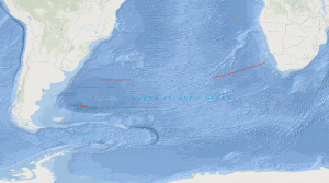
SONNE cruise SO-85 was designed to study the variability of the oceanic crustal structure along flow-line profiles over Early Tertiary through Early Cretaceous old crust in the Cape and Argentine basins of the South Atlantic. Between 21th February and 20th April 1993 deep imaging seismic reflection data in parallel with magnetic, gravimetric and hydroacoustic measurements have been collected along a 1,405 km long flow-line traverse across the Cape basin, and along three flow-line traverses across the Argentine basin with a total length of 4,255 km. A special geophysical survey was carried out on the Argentine continental margin. Although bad weather hampered the geophysical measurements in the Argentine basin, some new and intriguing observations were made: (1) the presence of an elongated wedge of seaward dipping reflectors, often associated with the distinct magnetic anomaly 'G', was confirmed on both, the South African and Argentine continental margins; (2) the sequence of seaward-dipping reflectors consists of two wedges. The younger wedge rests partly on the older one; (3) the surface of the oceanic crust lies more deep in the Argentine basin than in the Cape basin; (4) the structure of the oceanic crust is more variable in time and space within the Argentine and Cape basins than within the Angola and Brazil basins; (5) despite this, it appears that the oceanic crust generated during the younger half of the Cretaceous magnetic quiet period up to C 33r is characterized by relative high reflectivity in lower crustal levels; (6) high-amplitude magnetic anomalies C 33 through C 34 are apparently correlatable with oceanic crustal segments characterized by common seismic features, e.g. a smooth and scarped surface of the oceanic crust; (7) an elongated, positive gravity anomaly exists at about 58°E between 43.5°E and 47°E.
Allgemeine Geschäftsbedingungen, siehe http://www.bgr.bund.de/AGB - General terms and conditions, see http://www.bgr.bund.de/AGB_en. Die bereitgestellten Informationen sind bei Weiterverwendung wie folgt zu zitieren: Datenquelle: SO85 VOKSA 1993, (c) BGR, Hannover, 2018
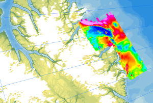
Onshore geological field work combined with an onshore/offshore aeromagnetic survey was carried out during a joint expedition of the German BGR and the Canadian GSC to understand the structural architecture of the North American continental margin. The helicopter-borne magnetic survey of 2008 covered the northern coastal areas of Ellesmere Island and the adjacent marine areas. The survey was conducted with a line separation of 2 km and covered a 40 to 50 km wide swath offshore about parallel to the north coast of Ellesmere Island from Yelverton Bay in the west to Parr Bay east of Cape Columbia, the northernmost point of Canada. Between Yelverton Bay and M'Clintock Inlet, the survey extended about 40 to 50 km inland, which was the prime target area of the CASE 11 geological investigations. This section of mountainous terrain was flown in a “draped” mode to keep the distance to ground at approximately 1500 ft, same as over the offshore areas. During a 4-weeks period in May/June 2008, close to 8000 km of aeromagnetic line data were acquired, covering an area of 12000 km².
Allgemeine Geschäftsbedingungen, siehe https://www.bgr.bund.de/AGB - General terms and conditions, see https://www.bgr.bund.de/AGB_en. Die bereitgestellten Informationen sind bei Weiterverwendung wie folgt zu zitieren: Datenquelle: AeromagCASE11, (c) BGR, Hannover, 2023
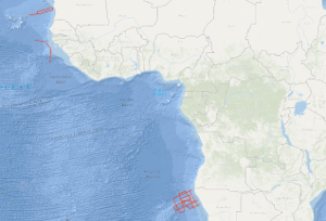
During the second leg of cruise BGR78 from 22th of February to 29th of March 1978 with R/V EXPLORA the following measurements have been carried out as presite- and postsite surveys of DSDP sites: (1) in the region of the eastern Walvis Ridge 4,350 km multichannel seismic reflection profiles, 4,540 km magnetic measurements, 5,000 km gravimetric measurements and sonobuoy refraction measurements on 11 stations (2) on the Guinea Plateau 740 km multichannel seismic reflection profiles in parallel with gravimetric and magnetic measurements (3) between Cape Verde islands and Mauretania 980 km multichannel seismic reflection profiles in parallel with magnetic measurements, 1,480 km gravimetric measurements and sonobuoy refraction measurements on 2 stations. The geophysical measurements show that the structure of the Walvis Ridge is determined by two main tectonic directions (WSW-ENE and SSW-NNE). Presumably the genesis of the fracture zone in the Walvis Ridge area can be traced back to the sea-floor spreading with overprinting effects due to an inhomogeneity in the mantle ("hot spot"). Both DSDP drilling projects in this part of the Walvis Ridge led to a fragmentary knowledge because site 362 got stuck at a depth of 1.100 m in the Oligocene. BGR's measurements indicate a gap of at least 1.000 m of sediments, especially from the cretaceous period, down to the (acoustic) basement. Site 363 at a submarine high has gaps in the depositional sequence and stops at a depth of 700 m shortly above the basement. So for a better understanding of the geologic development of the Walvis Ridge, further DSDP drillings with a recovery of the complete sedimentary sequence and the following basement cores are necessary. Therefore BGR's measurements of this cruise propose new DSDP sites.
Allgemeine Geschäftsbedingungen, siehe http://www.bgr.bund.de/AGB - General terms and conditions, see http://www.bgr.bund.de/AGB_en. Die bereitgestellten Informationen sind bei Weiterverwendung wie folgt zu zitieren: Datenquelle: BGR78-2 1978, (c) BGR, Hannover, 2019