The sampling sites (station 1-20) were located along or across the three main channels of the Wichter Ee. The investigation was carried out in March and in September 1998 with a motorboat. Due to the water level being too low, stations 8, 19 and 20 could not be sampled in March and staton 3 not in September. A 0,1 m² van Veen grab was used for sampling. At each station, two macrofaunal grab samples were taken and sieved over 0,5 mm mesh size. Species number, numerical abundance and biomass were each calculated as means of the two samples at each station.
Diskussion und Zusammenfassung: Die Untersuchung von Juni bis Oktober 1979 statt. Die Untersuchung der unteren Ems zwischen Emden und Papenburg ergab eine deutliche ökologische Gliederung in vier Abschnitte, die sich auf unterschiedlicher Artenzusammensetzung und flussaufwärts abnehmender Abundanz und Biomasse begründen. Allein der Abschnitt IV, die Leda, die bei Leerort in die Ems mündet, bildet eine Ausnahme. Trotz weiter reduzierter Artenzahl steigen hier Besiedlungsdichte und Biomasse wieder an. Eine mögliche Ursache dieser Erscheinung könnte in der Sedimentbeschaffenheit zu suchen sein. Summary: In the river Ems between Papenburg and Emden, which is the transition area from freshwater to lowly concentrated brackish water, a survey of the macrozoobenthos fauna (including Oligochaeta) of the intertidal mudflats was carried out. In addition, salinity distribution, properties of the sediment and composition of the intertidal reed belts ere investigated. The whole investigative area shows a very pronounced uniformity of the substratum. In all stations the material is composed of mud in more or less soft consistency which contains a blend of sand only in the upstream area, close to the channel, or in the vicinity of sluices.
Die vorliegenden Untersuchungen sind Bestandteil des Leybucht-Projektes der Forschungsstelle, in dessen Rahmen auch die hydrologischen Verhältnisse (LIEBIG 1984, NIEMEYER 1984), die Morphologie (STEPHAN 1984) und die Sedimentologie (RAGUTZKI 1984) bearbeitet worden sind. Die Zielsetzung dieser Arbeiten ist, das Bauvorhaben in seinen Auswirkungen auf das Gesamtgebiet der Leybucht und auf ihre künftige Entwicklung zu beurteilen. Schlussbemerkung: Abschließend kann über die Zukunftsaussichten der Leybucht gesagt werden: Die aus der morphologische Analyse (Höhenwachstum) und aus der Vegetationsentwicklung gewonnenen Einsichten sprechen dafür, dass die Verlandung nur noch langsam fortschreitet. Das geplante Bauvorhaben wird den Gang der natürlichen Entwicklung voraussichtlich wenig beeinflussen, da die Halbinsel Leyhörn die jetzigen Strömungs- und Seegangsverhältnisse unberührt lässt. Nach menschlichen Zeitmaß ist der bucht somit noch eine längere Existenz beschieden. Jedoch arbeitet die Zeit allmählich zugunsten der Salzwiesen und auf Kosten der Wattflächen. Diese Entwicklung kann Konsequenzen für die Vogelwelt mit sich bringen, da sie die gegenwärtig wohl besonders günstigen Lageverhältnisse zwischen Brut-, Nahrungs- und Rastbiotopen verändert. Die Wattenfauna der Leybucht ist nicht ungewöhnlich reich an Biomasse, wie mehrfach angenommen. Sie setzt sich aber aus leicht für Vögle verfügbaren und möglicherweise aus besonders produktiven Arten zusammen. Langfristig gesehen, stehen die Zeichen auf Verknappung, da Höhenwachstum und Flächenminderung der Watten die Biomasse reduzieren werden. Der Fortfall der durch die Halbinsel Leyhörn beanspruchten Bereiche verstärkt diese Entwicklung. Um das Flächenverhältnis zwischen Watten und Salzwiesen nicht unnötigerweise und nicht vorzeitig zu verändern, wird empfohlen, die Landgewinnungsarbeiten einzustellen. The bay „Leybucht“, situated in the lower reaches of the Ems estuary, was originally bound for total closure by land reclamation. However, in the course of the last 15 years the view changed because the extraordinary ecological value of the bay was recognized. Its extensive saltmarshes and mud flats form a unique habitat for breeding and migrating waders and waterfowl. Therefore, a total embankment seemed no more acceptable. Instead, a plan was developed to embank about 10 km² of foreland and tidal flats mostly outside of the Leybucht proper, in order to create a water reservoir for hinterland drainage and a new and deep channel for the fishing village Greetsiel. In the present study special aspects of the ecological impact of this coastal engineering project are investigated.
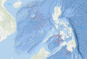
Within the framework of the research project SINDBAD (Seismic and Geoacoustic Investigations Along the Sunda-Banda Arc Transition) marine geophysical investigations have been carried out with RV SONNE from October 9th, 2006, to November 9th, 2006, off the eastern Sunda Arc and at the transition to the Banda Arc in Indonesia. The research cruise SO190 Leg 1 started in Jakarta, Indonesia and ended in Darwin, Australia. During this cruise, multichannel seismics (MCS), magnetics (M), and gravimetry (G) measurements have been carried out. Simultaneously, SIMRAD (multibeam echosounder) and PARASOUND (sediment echosounder) data have been collected using RV SONNEs onboard systems. During the expedition, a total of 4,933 km of profiles with MCS, M, and G have been acquired. Six of the 20 profiles are long overview profiles perpendicular to the deformation front and cover the entire forearc from the forearc basin across the outer arc high, the deformation front onto the oceanic lithosphere. Additional profiles have been acquired along strike in the Lombok forearc basin and in the Savu Basin. The main goal of the project SINDBAD is to investigate the relation between the variability of the lower plate and the tectonic evolution of the overriding plate (formation of an outer arc high, development of forearc basins, and accretion and erosion processes of the overriding plate). The "raw materials" – seafloor sediments, oceanic crust (at the Banda Arc also continental crust) and mantle lithosphere – are carried into the subduction system at the trench. The influence of these "raw materials" on the overriding plate is controlled by a number of factors: e.g. the convergence rate, the obliqueness of convergence and the physical and chemical properties of the lower plate (e.g. its age, its sediment-cover and –thickness, its fluid content and the composition of the crust). Forearc basins are today attracting increased attention because of their hydrocarbon potential. The forearc basins of the eastern Sunda Arc are still frontier areas which are almost unexplored. An additional goal of this project is therefore the assessment of the hydrocarbon potential of the Lombok Basin. In contrast to the Sumatra subduction zone, only a small amount of pelagic sediment is carried into the subduction system offshore East Java, Bali, Lombok, Sumbawa and Sumba. This results e.g. in a less pronounced development of the outer arc high, which is subaerial off Sumatra, but entirely below the sea surface in the eastern Sunda Arc. The Roo Rise, which is subducting off East Java, is a morphological high that lies about 1500 m higher than the Argo Abyssal Plain which is subducting further to the east. Despite of these pronounced differences, the deformation front in both areas shows similarities. While the foot of the slope shows lower dip than the upper slope, both areas are characterized by landward dipping thrust sheets. In both areas the outer arc high is characterized by active faults (the recent activity is indicated by deformed basin sediments on the outer arc high) and therefore no indications for a static backstop have been found. The accretionary character of the deformation front is clearly indicated in both areas, while subrosion in association with the subsidence of the Lombok Basin can not be excluded based on the preliminary interpretations. The trench in both areas is devoid of sediments, which indicates erosional processes caused by currents along the trench strike. However, a depocenter for these sediments could not be localized yet. While a forearc basin is not clearly developed off East Java, the Lombok forearc basin with water depths of more than 4000 m extends from off Bali to off Sumbawa. On the southern slope of the basin prograding sedimentary sequences indicate uplift, probably caused by the subducting Roo Rise or a growth of the outer arc high. Additionally, carbonate platforms on the acoustic basement indicate phases of rapid subsidence of the basin. The sediment thickness reaches a total of about 3.5 sec TWT. A few seismic "bright spots", but no bottom simulating reflectors (BSRs) have been identified in the basin. The profiles striking along the basin axis indicate paleo-depocenters in the western part of the profile, while the recent depocenter is located in the eastern part of the basin. On the northern flank of the Lombok basin, indications for submarine volcanism (recent activity is unknown) are indicated by a seamount reaching above the seafloor associated with a clear magnetic anomaly. East of the Lombok Basin the island of Sumba is located, which is regarded as a microcontinent that has been attached to the island arc during the Late Oligocene. Sumbas geographical location in front of the island arc is usually characterized by the location of a forearc basin and correlates with the seaward displacement of the deformation front (Roti Basin) at the transition from ocean/island arc subduction of the Sunda Arc to continent/island arc collision of the Banda Arc. An uplift of about 0.5 cm/a is reported for Sumba, associated with the underplating of the continental Scott Plateau. The uplift is especially evident in the MCS data. To the east of the Lombok Basin depocenter, a transition zone with deep reaching faults is observed, associated with eastward dipping sedimentary and basement structures. This transition zone is also indicated by anomalies in the magnetic and gravity data, the latter indicating isostatic undercompensation. On the western flank of Sumba, deformed sedimentary sequences indicate gravitational gliding in association with the uplift of Sumba. East of Sumba, two profiles into the Savu Basin have been acquired. Here the uplift of Sumba is indicated by the erosion of sedimentary sequences which have been deposited in the basin followed by uplift and subsequent erosion. Further indications of "inversion structures" are given by a reactivated thrust fault that in the past has served as the southern boundary of the Savu Basin und indicates recent activity by associated deformed basin sediments. The oceanic crust of the Argo Abyssal Plain and the Roo Rise is characterized by thin sediments. On a connection profile between two long profiles on the Argo Abyssal Plain a basin with about 1.4 sec TWT of sediment has been observed, that, indicated by a magnetic anomaly, can be correlated with an age jump of about 15 Ma, thereby indicating a paleo plate boundary.
Allgemeine Geschäftsbedingungen, siehe http://www.bgr.bund.de/AGB - General terms and conditions, see http://www.bgr.bund.de/AGB_en. Die bereitgestellten Informationen sind bei Weiterverwendung wie folgt zu zitieren: Datenquelle: SO190 SINDBAD 2006, (c) BGR, Hannover, 2019
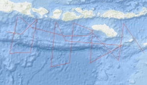
The SONNE cruise SO-49/1 from 6th April to 7th May 1987 was designed to investigate the Cotabato subduction zone off Mindanao and the geological structure of the eastern part of the Sulu Sea including the convergent continental margins off Zamboanga Peninsula, Negros, and Panay by a geophysical survey. On the 1st leg multichannel seismic reflection measurements were carried out in parallel with magnetic, gravimetric, sea beam and 3.5 kHz subbottom profiler measurements on 16 lines with a total length of 2,700 km. The SONNE cruise SO-49/1 was financed by the Federal Ministry of Research and Technology (BMFT). The geophysical survey in the Celebes Sea and in the Sulu Sea was carried out as a co-operative project by the Federal Institute for Geosciences and Natural Resources (BGR), the Bureau of Mines and Geoscience (BMG) and the Bureau of Energy Development (BED). 16 German scientists and technicians and 4 Philippine scientists attended SONNE cruise SO-49/1. The seismic lines surveyed across the Cotabato Trench/Celebes Sea and the Sulu Trench/Sulu Sea illustrate the active deformation of the layered sediments of the Celebes Sea and the SE Sulu Basin along the trenches: The seismic data suggest an active development of imbricate thrust sheets at the toe of the accretionary wedges and a simultaneous duplex-kind shortening within the wedges above the downgoing oceanic crust of the Celebes Sea and the SE Sulu Basin. The surface of the downgoing oceanic crust forms a major detachment plane or sole thrust. By these processes mass is added to the accretionary wedges resulting in thickening and growing of the wedges. The sedimentary apron overlaying the wedge is only mildly affected by these processes because the surface of the accretionary wedges forms a roof thrust. The collected geophysical data suggest that the oceanic SE Sulu Basin previously extended northward into Panay Island. It was closed by eastward subduction of oceanic crust beneath the upthrusted/updomed Cagayan Ridge. The Negros Trench, a 4.000 to 5,000 m deep bathymetric depression, is thought to represent the collision suture of the opposed subduction systems. The Cagayan Ridge which divides the Sulu Sea into the NW Sulu Basin and the SE Sulu Basin continues into the Antique Ridge of Panay. Approximately 45 suitable and problem-oriented sampling locations have been defined and documented for the subsequent geological and geochemical program by on-board analysis and interpretation of the seismic near trace records and the recordings of the 3.5 kHz subbottom profiler and the sea beam system. On cruise SO49/2 from 10th May to 21st June 1987, the research vessel SONNE of the Federal Republic of Germany undertook geoscience cruises in the South China Sea. The multidisciplinary study of the tectonic and natural resources of the region was a cooperative project between the Federal Institute for Geosciences and Natural Resources (BGR) and the Second Institute of Oceanography (SIO) in the frame of the Agreement between the State Oceanic Administration of the People's Republic of China and the Federal Ministry for Research and Technology of the Federal Republic of Germany on Cooperation in Marine Science and Technology. The first part of cruise SO49/2 was primarily to acquire multichannel seismic data, together with gravity, magnetic, sea beam, and 3.5 kHz measurements, and consisted of 4,112 km of traverses across the deep eastern and western sub-basins of the South China Sea from the Dangerous Grounds to the Chinese continental margin. The observed complex crustal deformation in the Southwestern South China Sea basin and in particular deep intracrustal reflection suggest a large-scale simple-shear kinematic mechanism for the development of at least the western sub-basins. The second part of cruise SO49/2 had primarily geological, geochemical and geothermal objectives and 21 dredge stations, 17 geochemical stations and 6 heat flow stations were carried out. The aims of the sampling were firstly to determine the lithologies and ages of the seismic sequences, and secondly to collect unconsolidated sediments for geochemical study of sorbed hydrocarbon gases in combination with heat flow measurements. Late Oligocene shallow-water carbonates dredged from 700 m to 2700 m of water depth indicate a strong subsidence of the investigated area. The underlying basement consists of continental crust with basaltic intrusions. The hydrocarbon gases of the outer continental slope originated by thermogenic processes from source rocks with a predominantly high maturity of the organic substances.
Allgemeine Geschäftsbedingungen, siehe http://www.bgr.bund.de/AGB - General terms and conditions, see http://www.bgr.bund.de/AGB_en. Die bereitgestellten Informationen sind bei Weiterverwendung wie folgt zu zitieren: Datenquelle: SO49 1987, (c) BGR, Hannover, 2019