Im Juli und Oktober 1963 wurde auf dem Knechtsand von der Forschungsstelle Norderney in Zusammenarbeit mit dem Geologischen Institut der Universität Kiel und dem Senckenberg-Institut für Meeresgeologie und -biologie, Wilhelmshaven, eine Untersuchung durchgeführt mit dem Ziel, die Eignung der Luminophorenmethode zum Erkennen des Materialtransportes auf dem Watt zu prüfen und mit dieser und anderen vergleichenden Methoden Erkenntnisse über die Materialwanderung auf dem Knechtsand zu erhalten. Es wurde zu diesem Zwecke ein Versuchsfeld in 100 m Abstand verpflockt und als Stationen 1-811 bezeichnet. An diesen Stationen wurden täglich die Höhenänderungen gemessen, außerdem 545 Kornanalysen und ebenso viele Wassergehalts- und Glühverlustbestimmungen durchgeführt. Die Fauna und Flora wurde untersucht, die Strömungen, Strömungsrichtungen und Wasserstandshöhen auf dem Watt und in der Robinsbalje gemessen sowie rund 300 Wasserproben auf Sinkstoffe, Luminophoren, Salzgehalt und Temperatur untersucht, Die Wetterdaten wurden von der Wetterwarte Cuxhaven zur Verfügung gestellt. (Forschungsstelle Norderney). Weiterhin wurde der Materialtransport an Oberflächenmarken und anhand von Gefügestudien und Stechkästenproben sowohl vom Watt als auch aus der Robinsbalje und den Nordergründen studiert. (Senckenberg-Institut, Wilhelmshaven). Zur Prüfung der Luminophorenmethode und zur Erzielung von Ergebnissen wurden 180 kg gelb und 120 kg rot markierter Sand auf dem Watt sowie 300 kg gelber und roter Sand in der Robinsbalje ausgegeben. Auf dem Watt wurden 1885 Sedimentproben und in der Robinsbalje 72 Bodengreiferproben entnommen und auf Luminophoren untersucht. (Geologisches Institut der Universität Kiel). Die Luminophorenmethode ist zum Studium des Materialtransportes auf dem Sandwatt geeignet, im Mischwatt und Schlickwatt kann sie nicht eingesetzt werden. Mit dieser und den anderen vergleichenden Methoden konnte ein Materialtransport quer über den Knechtsand, über die Wattwasserscheide hinweg, festgestellt werden. Mengenangaben über das transportierte Material sind nicht möglich, jedoch können die zurückgelegten Strecken nachgewiesen werden.
Im Juli und Oktober 1963 wurde auf dem Knechtsand von der Forschungsstelle Norderney in Zusammenarbeit mit dem Geologischen Institut der Universität Kiel und dem Senckenberg-Institut für Meeresgeologie und -biologie, Wilhelmshaven, eine Untersuchung durchgeführt mit dem Ziel, die Eignung der Luminophorenmethode zum Erkennen des Materialtransportes auf dem Watt zu prüfen und mit dieser und anderen vergleichenden Methoden Erkenntnisse über die Materialwanderung auf dem Knechtsand zu erhalten. Es wurde zu diesem Zwecke ein Versuchsfeld in 100 m Abstand verpflockt und als Stationen 1-811 bezeichnet. An diesen Stationen wurden täglich die Höhenänderungen gemessen, außerdem 545 Kornanalysen und ebenso viele Wassergehalts- und Glühverlustbestimmungen durchgeführt. Die Fauna und Flora wurde untersucht, die Strömungen, Strömungsrichtungen und Wasserstandshöhen auf dem Watt und in der Robinsbalje gemessen sowie rund 300 Wasserproben auf Sinkstoffe, Luminophoren, Salzgehalt und Temperatur untersucht, Die Wetterdaten wurden von der Wetterwarte Cuxhaven zur Verfügung gestellt. (Forschungsstelle Norderney). Weiterhin wurde der Materialtransport an Oberflächenmarken und anhand von Gefügestudien und Stechkästenproben sowohl vom Watt als auch aus der Robinsbalje und den Nordergründen studiert. (Senckenberg-Institut, Wilhelmshaven). Zur Prüfung der Luminophorenmethode und zur Erzielung von Ergebnissen wurden 180 kg gelb und 120 kg rot markierter Sand auf dem Watt sowie 300 kg gelber und roter Sand in der Robinsbalje ausgegeben. Auf dem Watt wurden 1885 Sedimentproben und in der Robinsbalje 72 Bodengreiferproben entnommen und auf Luminophoren untersucht. (Geologisches Institut der Universität Kiel). Die Luminophorenmethode ist zum Studium des Materialtransportes auf dem Sandwatt geeignet, im Mischwatt und Schlickwatt kann sie nicht eingesetzt werden. Mit dieser und den anderen vergleichenden Methoden konnte ein Materialtransport quer über den Knechtsand, über die Wattwasserscheide hinweg, festgestellt werden. Mengenangaben über das transportierte Material sind nicht möglich, jedoch können die zurückgelegten Strecken nachgewiesen werden.
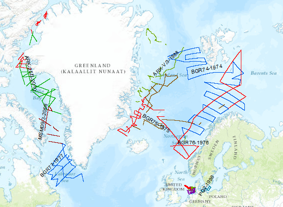
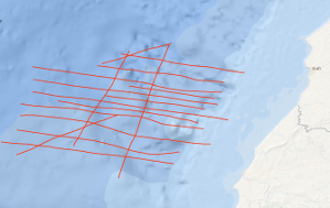
During the period from 1974 to 2023 various cruises from BGR acquired seismic lines worldwide. The aim of these marine expeditions were a detailed survey of the geological structure of seabed.
Allgemeine Geschäftsbedingungen, siehe https://www.bgr.bund.de/AGB - General terms and conditions, see https://www.bgr.bund.de/AGB_en. Die bereitgestellten Informationen sind bei Weiterverwendung wie folgt zu zitieren: Datenquelle: MSSP, (c) BGR, Hannover, 2023
In continuation of a fracture zone survey of BGR in 1985, there was a multichannel seismic survey of the Hayes Fracture Zone between 20°W and 27°W in the time from October 26th to November 11th, 1988. In spite of bad weather conditions, it was possible to collect a total of 1.760 km seismic and gravity data on 11 lines. From a first interpretation of the seismic monitor records on board it appears that the frequency of intra-crustal reflections in the records from the area west of 20°W is much less than on the records of the survey of the previous cruise in 1985. During a second leg in the time period from 14th November to 21th November 1988 an additional seismic survey of the Kane Fracture Zone took place with 7 supplementary profiles.
Allgemeine Geschäftsbedingungen, siehe http://www.bgr.bund.de/AGB - General terms and conditions, see http://www.bgr.bund.de/AGB_en. Die bereitgestellten Informationen sind bei Weiterverwendung wie folgt zu zitieren: Datenquelle: BGR88 1988, (c) BGR, Hannover, 1988
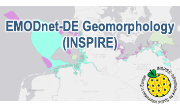
Compilation of the European marine geomorphology (section of Germany). According to the Data Specification on Geology (D2.8.II.4_v3.0) the geological map provides INSPIRE-compliant data. The WMS EMODnet-DE Geomorphology (INSPIRE) contains layers of the natural geomorphologic features (GE.GeomorphologicFeature) displayed correspondingly to the INSPIRE portrayal rules. Via the getFeatureInfo request the user obtains detailed information on the natural geomorphologic features.
Terms of Use: General terms and conditions, see https://www.bgr.bund.de/AGB_en. For further use provided information has to be cited as follows: EMODnet-DE (INSPIRE), (c) BGR Hannover, 2022
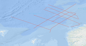
During cruise BGR79 from 29th June to 3rd September 1979 the Federal Institute for Geosciences and Natural Resources (BGR) carried out marine seismic reflection surveys in the three separate areas of the North Atlantic Ocean (Norwegian Sea, Scotian Basin, and U.S. East Coast Area) with S.V. EXPLORA. Simultaneously gravity, magnetic and reflection seismic data were recorded on parts of the lines. In addition, 66 sono-buoys were deployed for seismic refraction data recording on various seismic lines in all three areas. A detailed survey in the Norwegian Sea took place in the time from 29th June to 15th July, 1979 between the southern Vøring Plateau, the Jan Mayen Fracture Zone, the Møre Basin and the Faeroe-Shetland escarpment during leg 1 of cruise BGR79. The data showed that the Møre Basin contains a small sub-basin in the western part, the West-Shetland Basin. Further seaward, an outer high as well as a zone of intrusions were imaged.
Allgemeine Geschäftsbedingungen, siehe http://www.bgr.bund.de/AGB - General terms and conditions, see http://www.bgr.bund.de/AGB_en. Die bereitgestellten Informationen sind bei Weiterverwendung wie folgt zu zitieren: Datenquelle: BGR79/1 1979, (c) BGR, Hannover, 2018
During the period from 1974 to 2018 various cruises from BGR acquired seismic lines worldwide. The aim of these marine expeditions was a detailed survey of the geological structure.
Allgemeine Geschäftsbedingungen, siehe https://www.bgr.bund.de/AGB - General terms and conditions, see https://www.bgr.bund.de/AGB_en. Die bereitgestellten Informationen sind bei Weiterverwendung wie folgt zu zitieren: Datenquelle: MSSP, (c) BGR, Hannover, 2015
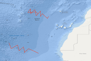
During leg 3 of cruise SO81, starting in Caldera/Costa Rica at September 15th and ending in Balboa/Panama at September 28th, 1992, the first 48-channel seismic survey was carried out in the Hess Deep area as a German contribution of pre-site investigations for Leg 147 of the Ocean Drilling Programme. ODP Leg 147 is designed to drill the crust-mantle transition. During leg SO81/3 the BGR collected 662 km of seismic data and in addition gravity and hydroacoustic measurements were carried out. Profile SO81-HD001 runs W-E from and to 1 Ma old oceanic crust across the East Pacific Rise. The profiles SO81-HD002 to SO81-HD007 are located in the proper Hess Deep area passing onto the proposed drill sites. Preliminary on-board evaluation of the seismic monitor records gives a lot of interesting intracrustal reflection events which deserve more elaborate examination after proper processing of the seismic data.
Allgemeine Geschäftsbedingungen, siehe http://www.bgr.bund.de/AGB - General terms and conditions, see http://www.bgr.bund.de/AGB_en. Die bereitgestellten Informationen sind bei Weiterverwendung wie folgt zu zitieren: Datenquelle: SO81/3 Hess Deep 1992, (c) BGR, Hannover, 2018
Compilation of the European marine geomorphology (section of Germany). According to the Data Specification on Geology (D2.8.II.4_v3.0) the content of the geological map is stored in an INSPIRE-compliant GML file: EMODnet-DE_Geomorphology_NaturalGeomorphologicFeature.gml contains the natural geomorphologic features. The GML file together with a Readme.txt file are provided in ZIP format (EMODnet-DE_Geomorphology-INSPIRE.zip). The Readme.text file (German/English) contains detailed information on the GML file content. Data transformation was proceeded by using the INSPIRE Solution Pack for FME according to the INSPIRE requirements.
During METEOR-Westafrica cruise 46, leg 1, geophysical measurements were carried out off Morocco between 31°30'N and 32°30'N in the time period from the 8th October to the 5th November 1977. Altogether 1,855 km of 24-fold reflection seismic data were collected on lines ME46-02 to ME46-11 and on lines ME46-14 to ME46-19. For the purpose of planning the programme, the reflection seismic data were processed (12-fold stack) aboard. 3,465 km of magnetic, gravimetric and bathymetric data were collected on lines ME46-01 to ME46-26 using the new BGR digital recording system. Along lines ME46-101 and ME46-102 with a total length of 209 km refraction seismic measurements were carried out with 6 moored telemetric buoys. A total of 164 shots with charges of 5 kg up to 200 kg were fired along the two lines in distances of about 1.5 km. A distinct fault zone was discovered in the area of investigation which is associated with a positive magnetic anomaly. The fault zone strikes NNE-SSW and probably marks the ocean-continent boundary. Beside diapiric structures (salt) allochthonous structures - thrust structures - are widespread features east of the discovered fault zone and below the lower continental slope. The seismic data indicate that the evolution of the old continental margin of the East Atlantic was also controlled by large scale gravity tectonics.
Allgemeine Geschäftsbedingungen, siehe http://www.bgr.bund.de/AGB - General terms and conditions, see http://www.bgr.bund.de/AGB_en. Die bereitgestellten Informationen sind bei Weiterverwendung wie folgt zu zitieren: Datenquelle: ME46 1977, (c) BGR, Hannover, 1977